Forecast for the Salt Lake Area Mountains

Drew Hardesty
Issued by Drew Hardesty for
Saturday, March 12, 2022
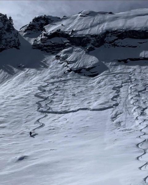
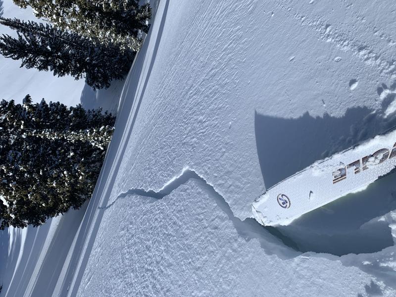
TODAY HAS AVALANCHE ACCIDENT WRITTEN ALL OVER IT.
***Please share our message.***
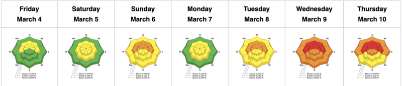
A CONSIDERABLE avalanche danger exists on steep west to north to east facing aspects of all elevations. These are dangerous, unmanageable avalanches 2-4' deep and a couple hundred feet wide. Know that you will trigger these from a distance. Know that you will see others riding steep terrain and getting away with it. You may not.
The danger for wet avalanches will reach CONSIDERABLE today on all steep solar aspects. Roof-alanches are a real hazard and expected today as homes shed the recent storm snow.
Low
Moderate
Considerable
High
Extreme
Learn how to read the forecast here
Special Avalanche Bulletin
The Utah Avalanche Center is issuing a SPECIAL AVALANCHE BULLETIN for Saturday, March 12, 2022.
We are very worried that a serious avalanche accident could occur this weekend. A CONSIDERABLE avalanche danger exists across northern and central Utah -
THIS IS WHEN WE SEE THE MOST ACCIDENTS AND FATALITIES.
DANGEROUS AVALANCHE CONDITIONS combined with great powder and beautiful weather make accidents likely. There have been many close calls this week, but luck eventually runs out. We commonly see a string of close calls leading up to serious accidents.
Two key messages:
  • Ensure everyone has and knows how to use an avalanche beacon, shovel, and probe.
  • Avoid being on, near or under all steep slopes and avalanche terrain. There is great riding and great powder on slopes less than 30 degrees in steepness where avalanches don’t occur.
Weather and Snow
Skies are clear. Mountain temperatures are in the mid-teens. West to northwest winds are 15mph with gusts to 20.
We'll have sunny skies, light to moderate westerly winds and mountain temperatures soaring into the upper 30s and low 40s.
It'll be a beautiful day in the mountains with excellent coverage and primo skiing and riding conditions.

A quick hitting system arrives tomorrow that should produce another 4-8" of snow. Clearing for early week with perhaps another storm mid-week.

Greg Gagne's Week in Review is published and can be found HERE.
Recent Avalanches
FOUR SIGNIFICANT AVALANCHES YESTERDAY. Areas include Cardiff Fork and Butler Basin of BCC, Lambs Canyon, and Farmington Canyon. These avalanches were on steep north to east facing slopes between 8000' and 10,300'. ALL of these were triggered at a distance. Each were big enough to be fatal.
A very close call occurred in the Ivory Slabs area of Cardiff Fork of BCC. The second skier on the slope triggered but escaped a 4-6' deep and 150' wide avalanche on steep east facing terrain at 10,300'. (INFO)
While walking the ridgeline above the Butler Basin in BCC, my own party collapsed the slope and triggered an 18"x250' wide avalanche below. The avalanche was on a steep NE facing slope at 9000'.

I have a short new blog post about accidents. It's called Deus Ex Machina.
Ad
Avalanche Problem #1
Persistent Weak Layer
Type
Location
Likelihood
Size
Description
The writing is on the wall. It's a perfect storm of blue skies, amazing riding conditions, and dangerous avalanche conditions.
ALL the red flags are there: Avalanches, Collapsing, Cracking, Poor Snowpack Structure, Rapid Warming, Recent Heavy Snowfall, Wind Drifting.
Travel Advice: Avoid being on or below steep slopes facing west to north to east on all elevations. We say below because you can trigger these avalanches from below the steep slope.

Avalanches: these are 2-4' deep and hundreds of feet wide. Big enough to bury you and snap bones as you get dragged through trees.
Collapsing: One of our staff Joey Manship wrote yesterday, "...within a couple minutes we noted a massive gut clenching collapse on a west facing slope just bellow 9000'. Within the next 15 minutes we noted 2 more thundering collapses.
The plot thickens, we took a second run and skinned up the same up track we had just put in and had 9 more collapses on the same skinner within about 150' vert. These where some of the biggest collapses I have felt in the Wasatch, visible watching the snow drop and crack around us. Made us very thankful to not be in avalanche terrain."
Cracking: My photo below from yesterday:
A few words of caution:
  • Signs of instability may not always be present: you may or may not see or experience shooting cracks or audible collapsing.
  • Tracks on the slope offer zero signs of stability. Avalanches will take out multiple existing tracks.
  • You can trigger these avalanches from a distance or below.
  • Another unusual thing is that many of these dangerous avalanches exist at lower elevations (at and below 8000') that usual. Example
Avalanche Problem #2
Wet Snow
Type
Location
Likelihood
Size
Description
Rapid warming and direct sun will create unstable wet snow avalanche problems on steep east to south to west facing slopes today. These wet avalanches have the capacity to run far and entrain tons of snow in steep confined terrain. This is a timing game. Avoid being on steep solar aspects when the snow has become wet and unsupportable.
Avalanche Problem #3
Wind Drifted Snow
Type
Location
Likelihood
Size
Description
Lingering unstable wind drifts can be found on all aspects at the highest elevations. These drifts will be soft and rounded and most pronounced on north to east to south facing aspects.
Additional Information
FORECASTER'S CORNER: I know you're hungry. So am I. January and February were among the driest on record and now the powder is excellent. But here's the thing: the powder will also kill you in steep terrain. Trust me. Very experienced people have been surprised in recent days. The skiing and riding is still good on low angle terrain. Wait for a bit and let it settle out.

Blog on "Our Jan/Feb Drought Layer and PWL Summary of Avalanche Activity on This Layering for the Central Wasatch Range." HERE.
General Announcements
Who's up for some free avalanche training? Get a refresher, become better prepared for an upcoming avalanche class, or just boost your skills. Go to https://learn.kbyg.org/ and scroll down to Step 2 for a series of interactive online avalanche courses produced by the UAC.
This information does not apply to developed ski areas or highways where avalanche control is normally done. This forecast is from the U.S.D.A. Forest Service, which is solely responsible for its content. This forecast describes general avalanche conditions and local variations always occur.