Join us at our 2nd Annual Blizzard Ball

Forecast for the Salt Lake Area Mountains

Greg Gagne
Issued by Greg Gagne on
Friday morning, February 7, 2020
The UAC has issued an AVALANCHE WARNING for the Salt Lake mountains. The avalanche hazard is HIGH at the mid and upper elevations, and CONSIDERABLE at low elevations, where strong winds and heavy snowfall have created dangerous avalanche conditions.
Avoid being on or underneath slopes any steeper than 30 degrees, and avoid avalanche runout zones. Travel in avalanche terrain is NOT recommended.

The avalanche hazard is especially acute in Little Cottonwood Canyon, where the hazard may be reaching EXTREME.
Low
Moderate
Considerable
High
Extreme
Learn how to read the forecast here
Avalanche Warning
IN EFFECT FROM 1 PM MST THURSDAY TO 6 AM MST SATURDAY
FOR THE MOUNTAINS OF NORTHERN UTAH INCLUDING THE WASATCH RANGE...BEAR RIVER RANGE...UINTA MOUNTAINS
THE AVALANCHE DANGER WILL BECOME HIGH ON MANY SLOPES AT DIFFERENT ELEVATIONS AND ASPECTS.
HEAVY DENSE SNOW AND WINDS UP TO 100 MPH HAVE CREATED CREATED WIDESPREAD AREAS OF UNSTABLE SNOW. BOTH HUMAN TRIGGERED AND NATURAL AVALANCHES ARE LIKELY. STAY OFF OF AND OUT FROM UNDER SLOPES STEEPER THAN 30 DEGREES.
Special Announcements
Discounted lift tickets - Thanks to the generous support of our Utah ski resorts and Ski Utah, all proceeds from these ticket sales go towards paying for avalanche forecasting and education! Get your tickets here.
Looking to improve your avalanche skills? We are offering a Backcountry 101: Introduction to Avalanches class at Powder Mountain February 14-15.
Weather and Snow
Currently: Temperatures range throughout the 20's F. Overnight, 6-10" of very dense fell, with the highest amounts in upper Little Cottonwood. 24-hour storm totals in LCC are nearly 2' and 4" of water, with about half those amounts in Big Cottonwood Canyon and the Park City ridgeline. Although snow totals may vary, strong winds out of the west/northwest aren't sparing any location. At the mid-elevations winds are averaging in the teens and 20's mph, with gusts in the 30's and 40's mph. At 11,000', winds have been averaging in the 40's and 50's mph, with gusts nearing 100 mph.
Today: Continued strong winds out of the west/northwest and periods of heavy snowfall, with temperatures in the 20's F. At the mid-elevations, winds will average in the 20's with gusts in the 30's and 40's mph. At the upper elevations, winds will average in the 40's with gusts in the 70's mph. Another 5-10" of very dense snowfall is expected throughout the day.

Our Week in Review which highlights weather and avalanche activity over the past week can be found HERE.
Recent Avalanches
We have received reports this morning of "extensive natural avalanche" activity in upper Little Cottonwood Canyon, including major avalanche paths that have crossed the road.
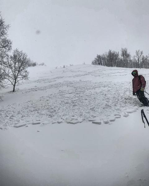
We received numerous backcountry observations from Thursday - thank you! - with widespread reports of sensitive conditions. This included natural and human-triggered avalanches, with some avalanches triggered remotely (from a distance.) Avalanches were failing at the storm snow interface, or down on a crust that formed over this past weekend. Although there were many reports of avalanches and red-flag conditions, the two avalanches that caught my attention were (1) a 1000'-wide avalanche on the east face of Reynold Peak (observation - Mark White photo below), and (2) a near-miss in one of the Memorial Couloirs on Mount Olympus (excellent observation) where two skiers were caught in a natural avalanche as they were booting up the couloir. Fortunately, no injuries were reported. (I have further thoughts on the conditions in Millcreek and Neffs Canyons under "Additional Information")
Ad
Avalanche Problem #1
New Snow
Type
Location
Likelihood
Size
Description
Very heavy and dense snowfall that began early Thursday morning fell on top of very light/weak snowfall from earlier this week, instantly creating a dangerous structure of a strong slab over weaker snow. This problem is particularly acute in upper Little Cottonwood Canyon which has received well over 2' of storm snow containing over 4" of water. Additional snowfall today will only further stress the snowpack.
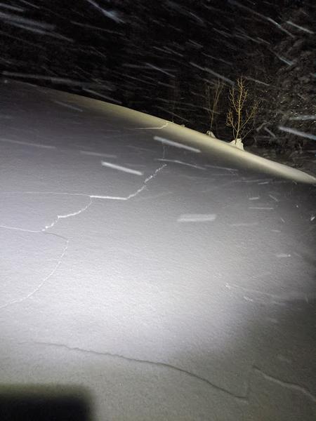
Watch for signs of instability ("red flags") including avalanches, cracking (photo below), and collapsing.
Avalanche Problem #2
Wind Drifted Snow
Type
Location
Likelihood
Size
Description
Very strong winds out of the west/northwest at the mid and upper elevations will continue to create 1-3' deep wind drifts on all aspects. Recent and fresh wind drifts will be most pronounced at the upper elevations, but you are also likely to find them in mid-elevation terrain as well.
Although cracking is a sign of instability in wind-drifted snow, these dense drifts may not show their sensitivity so easily, and allow you to get well out onto a slope before fracturing widely.
Additional Information
Foothills and East Bench Canyons: Monday's storm favored locations such as Millcreek and Neffs Canyons, where over 2' of very low-density snow fell. We received numerous reports on Thursday from these regions indicating sensitive conditions, including the natural avalanche in one of the Memorial Couloirs that caught and carried two skiers as they were booting up Memorial #5. Warming temperatures, rain to ~6,000', additional dense snowfall, and winds have overloaded this low-density snow, creating an avalanche hazard in what many would ordinarily consider safer, low to mid-elevation terrain. I travel quite a bit in these east-bench canyons and would be especially wary of the unusual avalanche conditions in this zone.
Mountain Weather Briefing from NWS Office
General Announcements
This information does not apply to developed ski areas or highways where avalanche control is normally done. This forecast is from the U.S.D.A. Forest Service, which is solely responsible for its content. This forecast describes general avalanche conditions and local variations always occur.