Join us at our 2nd Annual Blizzard Ball

Forecast for the Salt Lake Area Mountains

Mark Staples
Issued by Mark Staples on
Thursday morning, February 6, 2020
As winds blow and more snow falls, the danger is rising today. The danger can vary a lot today as some places get a lot of snow and other places get much less. Today's danger ratings are based on higher snow amounts as have already occurred in Little Cottonwood Canyon.
HEADS UP - Watch for snow sliding off roofs today if rain begins falling. A roof avalanche killed a woman in Washington this winter. Kids are especially vulnerable since they often play near homes and can be unsupervised.

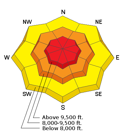
At upper elevations with the most snow and most wind, the avalanche danger is HIGH. In these places natural avalanches are already happening and more should occur.
At mid elevations, soft slab avalanches should become easy to trigger today and the danger is CONSIDERABLE. The size and depth of these slabs is dependent on how much snow falls.
Low elevations will have a MODERATE danger.
Low
Moderate
Considerable
High
Extreme
Learn how to read the forecast here
Avalanche Warning
IN EFFECT FROM 1 PM MST THURSDAY TO 6 AM MST SATURDAY
FOR THE MOUNTAINS OF NORTHERN UTAH INCLUDING THE WASATCH RANGE...BEAR RIVER RANGE...UINTA MOUNTAINS
THE AVALANCHE DANGER WILL BECOME HIGH ON MANY SLOPES AT DIFFERENT ELEVATIONS AND ASPECTS.
HEAVY DENSE SNOW AND WINDS UP TO 100 MPH HAVE CREATED CREATED WIDESPREAD AREAS OF UNSTABLE SNOW. BOTH HUMAN TRIGGERED AND NATURAL AVALANCHES ARE LIKELY. STAY OFF OF AND OUT FROM UNDER SLOPES STEEPER THAN 30 DEGREES.
Special Announcements
Discounted lift tickets - Thanks to the generous support of our Utah ski resorts and Ski Utah, all proceeds from these ticket sales go towards paying for avalanche forecasting and education! Get your tickets here.
Looking to improve your avalanche skills? We are offering a Backcountry 101: Introduction to Avalanches class at Powder Mountain February 14-15.
Weather and Snow
Overnight most areas have only received 1-2 inches of snow. HOWEVER, Little Cottonwood Canyon has received 9 inches as of 6 a.m.
Temperatures are ten degrees warmer than they were at 6 p.m. yesterday. Most places have temperatures in the upper teens and low 20s F. Temperatures don't vary much with elevation.
Winds at most ridgetops are blowing 10-20 mph and gusting 30 mph from the west and northwest. At the highest peaks near 11,000 feet, winds are blowing 40-60 mph with some gusts of 90 mph.
Today, strong W and NW winds will continue today with temperatures rising into the mid and upper 20s F. Snow will continue all day and tonight. A brief lull is possible this afternoon. By the end of the day, 6-10 inches should accumulate with a similar amount falling tonight. Scroll to the bottom for a video of a weather briefing from the National Weather Service.
The new snow is denser (about 7% this morning) than the very low density powder under it. On many slopes there is a hard ice crust underneath snow that has fallen since Monday. North facing slopes do not have this crust. Riding conditions shouldn't be the best with this upside down snow. Looking ahead, as the snow settles and compresses, riding conditions should be much better sometime this weekend.
Below 6000 feet - precipitation should switch to rain late this morning. It shouldn't be heavy rain that causes widespread wet avalanches but enough to make the snow surface wet.
Recent Avalanches
NATURAL AVALANCHES ARE OCCURRING in Little Cottonwood Canyon which had received the most snow. This avalanche activity started happening at 4 a.m., and it is a good indication of what should happen in other areas as snow falls today.
A few avalanches happened early this week that broke in the new snow that fell on Monday (Toledo Bowl, Mt Olympus Memorial Couloirs, and Mt. Wolverine)
Ad
Avalanche Problem #1
New Snow
Type
Location
Likelihood
Size
Description
Here's the situation: Following a warm weekend, temperatures plummeted Sunday and snow fell on Monday. In most mountain locations only 4-10 inches fell despite much higher snow amounts in the valley and places like Mill Creek and Neff's Canyons. This snow was very low density and may have weakened some during very cold weather. One southerly facing slopes, this light snow rests on a hard ice crust.
Today's snow is denser and has formed a soft slab on top of Monday's very light snow. This set up is called upside down snow.
As more snow falls and the slab will become thicker, avalanches will become larger, and avalanches will become easier to trigger. Many places only have an inch or two of snow this morning, but there should be more snow falling today. Places with more snow will generally have more dangerous avalanche conditions than places with less new snow.
Avalanche Problem #2
Wind Drifted Snow
Type
Location
Likelihood
Size
Description
Very strong winds at upper elevations are likely causing the natural avalanches occurring this morning in Little Cottonwood Canyon. The danger created by upside down snow will be made worse by today's strong westerly winds.
At upper elevations, these winds should move enough snow to continue causing soft slabs of wind drifted snow to avalanche naturally. If they don't slide on their own, they should be very easy for a person to trigger.
The size and sensitivity of today's wind slabs will increase as more snow falls and winds continue blowing. Winds have been blowing from the west and northwest, but look for freshly wind loaded slopes on any aspect. These slopes can be loaded from the top of ridges or across the sides of other ridges.
Additional Information
General Announcements
This information does not apply to developed ski areas or highways where avalanche control is normally done. This forecast is from the U.S.D.A. Forest Service, which is solely responsible for its content. This forecast describes general avalanche conditions and local variations always occur.