Join us at our 2nd Annual Blizzard Ball

Forecast for the Salt Lake Area Mountains

Trent Meisenheimer
Issued by Trent Meisenheimer on
Saturday morning, February 8, 2020
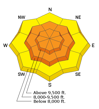
The avalanche danger is CONSIDERABLE on all steep slopes at the mid and upper elevations. Strong winds and heavy snowfall have created dangerous avalanche conditions. Cautious route-finding and conservative decision making will be essential today.
There is a MODERATE danger at all low elevations where it remains possible to trigger a soft slab avalanche within the new snow.
Travel Advice: Avoid being on or underneath any slope steeper than 30° degrees, and avoid avalanche runout zones. Give the snowpack some time to adjust and gain strength as it won't be long before the new snow stabilizes and we can get after it once again.
Low
Moderate
Considerable
High
Extreme
Learn how to read the forecast here
Special Announcements
Discounted lift tickets - Thanks to the generous support of our Utah ski resorts and Ski Utah, all proceeds from these ticket sales go towards paying for avalanche forecasting and education! Get your tickets here.
Looking to improve your avalanche skills? We are offering a Backcountry 101: Introduction to Avalanches class at Powder Mountain February 14-15.
Our Week in Review which highlights weather and avalanche activity over the past week can be found HERE.
Weather and Snow
Under clear skies this morning the westerly winds have finally relaxed to a more reasonable speed. However, the next cold front in on our door step and will be crossing northern Utah around the lunch hour. Currently, the mountain winds are from the west and north blowing 10-15 mph with gusts into 20's at most ridge-top stations. At 11,000' it's a different story where the wind is blowing from the west at 40-50 mph gusting into the 80's. Mountain temperatures are in the upper teens to low 20's °F across the board.
As this next trough moves overhead this afternoon the wind will quickly veer to the north behind the initial front bringing a bump in the wind speeds along with much colder air. We should see an additional 2-5" of snow from this storm by this evening. As the storm moves south it becomes a closed low and decides to take a vacation to Tijuana. Unfortunately, as the storm sets up into a closed low we will get the dreaded east and northeast winds beginning on Monday.

The storm totals from the past few days are very impressive! especially the water amounts. List below:
  • Little Cottonwood Canyon: 30"-41" of snow (5.52" - 6.79" water)
  • Big Cottonwood Canyon: 12"-18" of snow (2.25" - 3.50" water)
  • Park City Ridgeline: 9"-13" of snow (1.50" - 2.05" water)
  • Ogden Area Mountains: 7"-16" of snow (1.95" - 2.88" water)
Recent Avalanches
Dave Richards from the Alta Avalanche Office just recorded the longest period of sustained westerly winds in their history. Wind, combined with heavy snowfall created a massive natural and explosive triggered avalanche cycle in Little Cottonwood Canyon. Many large avalanches crossed the closed highway leaving behind huge debris piles with large trees. Tanners, Whitepine Chutes, Cottonwood Draw, Superior, and Toledo bowl we among the largest of the reported avalanches that crossed the closed highway. Alta also reported an explosive triggered avalanche that broke into old snow on a north facing slope at 10,700' in elevation. The crown was 6' deep.
In the backcountry, observers still noted the upside down structure to the snowpack and many of them gave avalanche terrain a wide berth and stuck to low angled terrain.
Ad
Avalanche Problem #1
New Snow
Type
Location
Likelihood
Size
Description
Very heavy and dense snowfall that began early Thursday morning fell on top of very light/weak snowfall from earlier this week, instantly creating a dangerous structure of a strong slab over weaker snow. The good news is that we aren't dealing with a persistent weak layer in our snowpack and the new snow will rapidly stabilize.
However, it's only been 12 hrs since the last snowflakes fell and it's too early to trust steep avalanche terrain. Let the new snow sit for another day or two and gain strength by sticking to low angle terrain (less than 30°) where the snow is fun, fast and surfy. Any avalanche that you trigger today has the potential to be 2-3' feet deep and hundreds of feet wide. These slides won't be friendly as they contain a lot of mass and weight. These are bone crushing avalanches.
Avalanche Problem #2
Wind Drifted Snow
Type
Location
Likelihood
Size
Description
Unusual weather creates unusual avalanches. It will only be more complicated at the upper elevation ridgelines where even more snow and water weight was added to the starting zones. Winds blew from the west continually at speeds of 30-40 mph for the past 48 hrs and I would bet many of the upper elevation ridgelines are just waiting for a trigger today.
Although cracking is a sign of instability in wind-drifted snow, these dense drifts may not show their sensitivity so easily, and allow you to get well out onto a slope before fracturing widely. Give the snowpack some time to settle and adjust to it's new load. Ride slopes that are less than 30° degrees in steepness and avoid runout zones today.
General Announcements
This information does not apply to developed ski areas or highways where avalanche control is normally done. This forecast is from the U.S.D.A. Forest Service, which is solely responsible for its content. This forecast describes general avalanche conditions and local variations always occur.