UDOT PLANNED AVALANCHE CLOSURES!!

Forecast for the Salt Lake Area Mountains

Greg Gagne
Issued by Greg Gagne for
Friday, November 4, 2022
The avalanche danger is Low on all aspects. The two avalanche problems to watch for are (1) wind-drifts in exposed slopes along upper-elevation ridge lines, and (2) long-running sluffs in the new snow on steep slopes.
If wind speeds increase earlier or are stronger than forecast, the avalanche danger could rise to Moderate where there are fresh wind drifts.
Expect a rising avalanche danger over this weekend with heavy, dense snowfall and strong winds.
Low
Moderate
Considerable
High
Extreme
Learn how to read the forecast here
Special Announcements
Remember to treat ski areas as backcountry terrain and check each resort's travel restrictions on the Resort Uphill Policy page before accessing their terrain.
The ski areas are getting ready for their operating seasons to start so please be respectful of equipment and employees both on and off the slopes.
Give snowcats and snowmobiles a wide berth as they move around their terrain.
With the start of the season it's time to brush up on some continuing education. Check out the upcoming PROSAW and USAW, events next week.
Weather and Snow
Snowfall ended Thursday morning with settled storm totals around 12". Snowpack depths are 1-3' with the deepest amounts in upper Little Cottonwood. The Ogden and Provo mountains have snowpack depths roughly half that amount.
Temperatures this morning are in the upper single digits and winds are from the west/northwest and generally light, averaging less than 10 mph with gusts in the teens. Along the most-exposed upper-elevation ridges, the west/northwest winds are averaging in the 20's mph with gusts in the low 30's.
For today, increasing clouds with temperatures rising into the 20's F. Winds will be from the west/northwest and increasing this afternoon. At mid elevations, winds will average in the teens with gusts in the 20's mph. Wind speeds along exposed upper-elevation ridges will average in the 20's with gusts around 40 mph.
Expecting increasing winds and snowfall overnight and into Saturday with heavy snowfall and strong winds forecast for Saturday afternoon and evening.
Recent Avalanches
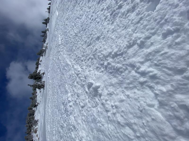
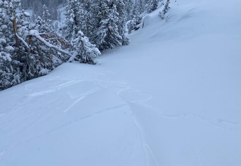
Avalanche activity from Thursday included long-running sluffs in the new snow on steeper slopes with debris piles 2-3' deep [Photo: below Vicki] and shallow wind slabs along upper elevations ridges.
Check out observations page for the most recent observations and avalanche activity. Thank you for all the observations we have received - please keep them coming!
Although we are off to a good start to our winter season with supportable snow and decent coverage, our nascent snowpack is still thin. Getting caught in even a small avalanche could be consequential with so many natural hazards such as rocks and stumps partially exposed or barely hidden.
Ad
Avalanche Problem #1
Wind Drifted Snow
Type
Location
Likelihood
Size
Description
Pockets of shallow wind drifts may be found in isolated areas along upper elevation ridges and exposed, open slopes. With increasing winds from the west/northwest forecast this afternoon, additional wind-drifting is possible. Cracking in denser snow - as shown in the photo below from Bill Nalli - is a sign of sensitive wind drifts.
Avalanche Problem #2
New Snow
Type
Location
Likelihood
Size
Description
Although instabilities within the storm snow appear to be settling, long-running sluffs in the new snow remain possible on steeper slopes. What caught my attention in Bill Nalli's (usual) excellent observation from Thursday was "It[ [the loose snow avalanche] ran surprisingly far and stopped half way down the slope where the slope angle decreases." [Photo: Bill Nalli]
Additional Information
A Few Things to Remember:
  • It doesn't matter what you're doing in the mountains-going for a hike, hunting, trying to ski, board, snowshoe or firing up the snowmachine: be prepared for avalanches
  • Triggering any avalanche regardless of its size can produce serious trauma because of a thin snowpack
  • Hitting rocks and stumps is a real danger. Don't end your season early from hitting one of these obstacles
  • Treat ski resorts as backcountry terrain and check out the UAC site for resort uphill travel policies

Even if you're not planning to get onto the snow, it's never too early to start thinking about avalanches. A few things to consider doing:
1. Attend USAW and learn more about avalanches and decision making. (scroll down to the bottom of this page for more info and links)
2. Sign up for an avalanche class.
4. Take the all-new online avalanche courses the UAC built for Know Before You Go or take other online courses listed on the KBYG website (Develop skills -> Online Learning).
5. Get your avalanche rescue gear ready for winter. Put fresh batteries in your transceiver and update the firmware. Inspect your shovel and probe. Get your airbag backpack ready by possibly doing a test deployment and update the firmware if it is an electric version.
Sign up for the 15th Annual Utah Snow and Avalanche Workshop (USAW) one night left, November 9th. Sign up and get more info for the second session HERE.
The Avalanche Professional and Ski Patrol Snow and Avalanche Workshop (PROSAW) will be during the day of November 7th. Sign up and get more info HERE. (note - PROSAW will be offered both in-person and virtual).
General Announcements

This information does not apply to developed ski areas or highways where avalanche control is normally done. This forecast is from the U.S.D.A. Forest Service, which is solely responsible for its content. This forecast describes general avalanche conditions and local variations always occur.