UDOT PLANNED AVALANCHE CLOSURES!!

Forecast for the Salt Lake Area Mountains

Dave Kelly
Issued by Dave Kelly for
Thursday, November 3, 2022
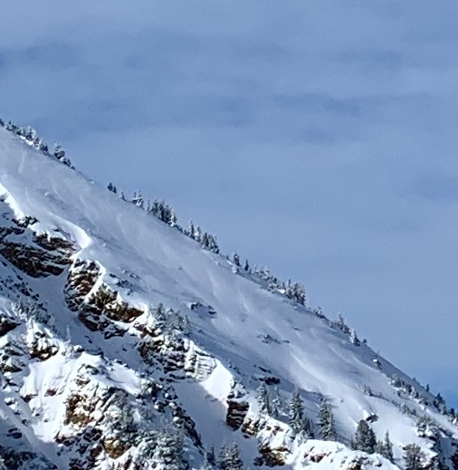
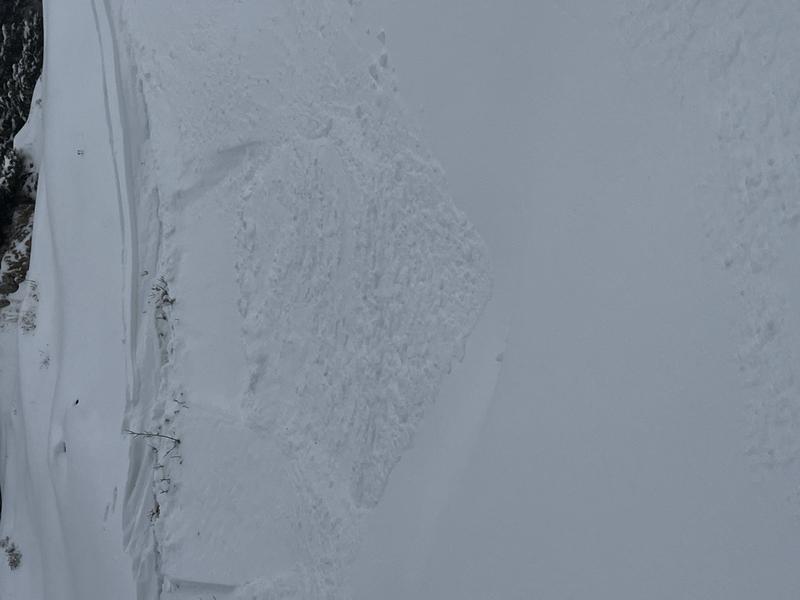
With a foot of new snow and strong winds be wary of steep slopes that may be holding wind slabs. You may NOT see signs of cracking or collapsing and even a small slide on steep unsupported terrain could drive you into rocks and stumps potentially ruining your season. You may trigger shallow wind drifts and loose snow avalanches in steep terrain today.
Heads up for this weekend's wet, warm, and windy storm.
Low
Moderate
Considerable
High
Extreme
Learn how to read the forecast here
Special Announcements
Remember to treat ski areas as backcountry terrain and check each resort's travel restrictions on the Resort Uphill Policy page before accessing their terrain.
The ski areas are getting ready for their operating seasons to start so please be respectful of equipment and employees both on and off the slopes.
Give snowcats and snowmobiles a wide berth as they move around their terrain.
With the start of the season it's time to brush up on some continuing education. Check out the upcoming Beacons in the Park, PROSAW, and USAW, events next week.
Weather and Snow
With a foot of snow and just over an inch of water pasted across the Central Wasatch, yesterday's event was a great base-building storm. The storm started off with strong winds from the south gusting to the 60's with periods of increased snowfall throughout the day. The Ogden area mountains reported just under a foot of new snow with an inch of water and the Provo area mountains reported eight inches of snow and just under an inch of water.
Currently we have broken skies with temperatures in the high teens at mid elevations and low teens at the highest ridgelines with winds blowing light from the north.
For today we're looking at up to 1-3" new snow primarily this afternoon with winds from the north, 15 gusting to 25 mph and high pressure building into Friday. Looking forward to Saturday we've got a warm, windy, snowy event forecasted.
Recent Avalanches
There was a natural cycle on steep north facing terrain that may have coincided with increased southerly winds and higher snowfall rates. There were several reports from upper Little Cottonwood Canyon of skier triggered sloughing within the storm snow and hand pits around Collins Gulch and Albion Basin confirmed this.
Check out our observations page for the latest updates from around Utah. Please keep these observations coming.
Sloughing in Eagle's Nest (Norris)
Ad
Avalanche Problem #1
Wind Drifted Snow
Type
Location
Likelihood
Size
Description
Watch for wind drifted snow on isolated terrain features and steep unsupported north facing slopes. There are two wind slab hazards worth looking for. The harder slab from prior to the new snow which will be on north and northwest aspects and the softer new snow wind slab which will be easier to see.
Wind scalloped snow prior to the last storm (Hardesty)
Avalanche Problem #2
New Snow
Type
Location
Likelihood
Size
Description
There was some graupel noted in the new snow and this may not settle out as quickly as the other density changes. Be aware of places where skiers could trigger new snow avalanches isolated to ski or snowboard tracks.
Upper Collins Gulch (Alden)
Additional Information
A Few Things to Remember:
  • It doesn't matter what you're doing in the mountains-going for a hike, hunting, trying to ski, board, snowshoe or firing up the snowmachine: be prepared for avalanches
  • Triggering any avalanche regardless of its size can produce serious trauma because of a thin snowpack
  • Hitting rocks and stumps is a real danger. Don't end your season early from hitting one of these obstacles
  • Treat ski resorts as backcountry terrain and check out the UAC site for resort uphill travel policies

Even if you're not planning to get onto the snow, it's never too early to start thinking about avalanches. A few things to consider doing:
1. Attend USAW and learn more about avalanches and decision making. (scroll down to the bottom of this page for more info and links)
2. Sign up for an avalanche class.
4. Take the all-new online avalanche courses the UAC built for Know Before You Go or take other online courses listed on the KBYG website (Develop skills -> Online Learning).
5. Get your avalanche rescue gear ready for winter. Put fresh batteries in your transceiver and update the firmware. Inspect your shovel and probe. Get your airbag backpack ready by possibly doing a test deployment and update the firmware if it is an electric version.
Sign up for the 15th Annual Utah Snow and Avalanche Workshop (USAW) one night left, November 9th. Sign up and get more info for the second session HERE.
The Avalanche Professional and Ski Patrol Snow and Avalanche Workshop (PROSAW) will be during the day of November 7th. Sign up and get more info HERE. (note - PROSAW will be offered both in-person and virtual).
General Announcements

This information does not apply to developed ski areas or highways where avalanche control is normally done. This forecast is from the U.S.D.A. Forest Service, which is solely responsible for its content. This forecast describes general avalanche conditions and local variations always occur.