Forecast for the Salt Lake Area Mountains

Greg Gagne
Issued by Greg Gagne for
Friday, November 25, 2022
The snowpack is generally stable and avalanches are unlikely. Watch for pockets of wind-drifted snow in upper elevations and sluffing in the dry, loose snow on steeper aspects as small avalanches are possible in isolated areas or extreme terrain

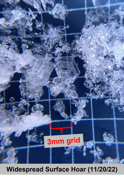
With snow forecast for this coming week, expect a rising avalanche danger.
Low
Moderate
Considerable
High
Extreme
Learn how to read the forecast here
Special Announcements
Join the Utah Avalanche Center and the Division of Outdoor Recreation to celebrate the Fourth Annual Avalanche Awareness week, from December 4 - December 11. Click HERE to view the full list of events for the week.

Most ski areas are now closed to uphill travel as they open or prepare to open for winter operations. Resort uphill travel policies can be found HERE.
Alta Ski Area has closed the Summer Road and access to Catherine's for lift area operations. Grizzly Gulch remains open. The Highway to Heaven above Twin Lakes is closed.
9990' lift is open; Canyons village of PC wants to remind their visitors that there is no backcountry access from 9990'.
Weather and Snow
Friday: Warm and sunny with temperatures rising into the 30's F. Winds will be from the north and northeast, averaging in the 20's with gusts in the 30's mph in the upper elevations.
Saturday: A weak cold front with partly-cloudy skies and maybe a snow flurry or two. Temperatures in the 20's F with west/northwest winds.
Sunday: Partly-cloudy with temperatures in the 20's F.

In the meantime, backcountry travel remains generally easy with good riding conditions. Some wind and sun damage exists in the alpine and on solar aspects, respectively, but sheltered slopes hold soft recrystallized snow. Snow depths are 3-4' in the upper reaches of the Cottonwoods and 2-3' along the Park City ridgeline. Ogden snow depths are 2-3' while Provo trails with only 1-2' snow on the ground.
Two weeks of cold, clear weather has drastically altered our snowpack where we now have weak, faceted snow and surface hoar on the surface: (McKinley Talty photo)
On Wednesday, UAC staff was finding the weak snow at the surface was reactive to the small amounts of new and wind-drifted snow.
With snowfall forecast for this coming week, this weak snow at the snow surface will likely create widespread and dangerous avalanche conditions.
Right now is an excellent opportunity to take note and begin mapping the variability and surfaces that are currently covering the range, as this will soon enough become the base of our snowpack for the season.


From Ogden to the central Wasatch to the Provo mountains, we have received several excellent observations. You can find them HERE. Please keep these excellent reports coming.
Ad
Avalanche Problem #1
Normal Caution
Type
Location
Likelihood
Size
Description
Although the snow surface is very weak, the current snowpack is generally stable and human-triggered avalanches are unlikely, but small avalanches in isolated areas are still possible:
  • A period of sustained winds from the north/northeast Wednesday and Thursday created isolated pockets of wind-drifted snow 12-24" thick in the upper elevations. These drifts may be stubborn and break above you.
  • Sluffing in the dry, cohesion-less snow on steep aspects.

Remember, even a small avalanche can be consequential in steep terrain.
General Announcements

This information does not apply to developed ski areas or highways where avalanche control is normally done. This forecast is from the U.S.D.A. Forest Service, which is solely responsible for its content. This forecast describes general avalanche conditions and local variations always occur.