Forecast for the Salt Lake Area Mountains

Nikki Champion
Issued by Nikki Champion for
Wednesday, November 23, 2022
Today, the snowpack is generally stable and avalanches are unlikely. However, with a few inches of new snow and elevated winds, shallow dry loose avalanches, as well as small slabs of wind-drifted snow will be something to think about.
Small avalanches are possible in isolated areas or extreme terrain. Remember that risk is inherent in mountain travel.

We are continuing to only issue intermittent updates.
Low
Moderate
Considerable
High
Extreme
Learn how to read the forecast here
Special Announcements
Join the Utah Avalanche Center and the Division of Outdoor Recreation to celebrate the Fourth Annual Avalanche Awareness week, from December 4 - December 11. Click HERE to view the full list of events for the week.

Most ski areas are now closed to uphill travel as they open or prepare to open for winter operations. Resort uphill travel policies can be found HERE.
Alta Ski Area has closed the Summer Road and access to Catherine's for lift area operations. Grizzly Gulch remains open. The Highway to Heaven above Twin Lakes is closed.
9990' lift is open; Canyons village of PC wants to remind their visitors that there is no backcountry access from 9990'.
Weather and Snow
This morning, skies are overcast with light to moderate snowfall. Mountain temperatures are currently in the upper teens' F to mid-twenties F. Over the last 12 hours, the west-northwesterly winds have averaged 10-20 mph at mid-elevations, with some gusts near 70 mph at the uppermost elevation. No measurable accumulation as of 6 AM.
Today, skies will remain mostly cloudy with the occasional light snowfall. Very little additional accumulation is expected 1 to 3 inches. Temperatures will climb into the mid-twenties F. Winds will remain west-northwesterly averaging 10-20 mph at mid-elevations, and 20-30 mph at upper elevations with gusts up to 45 mph at the highest ridgelines.
Looking ahead, an even weaker storm system is expected to graze northern Utah on Saturday. The weather models hint at a pattern change by the end of the month.

In the meantime, backcountry travel remains generally easy and riding conditions are pretty good for mid-November. Some wind and sun damage exists in the alpine and on the solar aspects, respectively, but sheltered parts hold soft recrystallized snow. Snow depths are 3-4' in the upper reaches of the Cottonwoods and 2-3' along the Park City ridgeline. Ogden snow depths are 2-3' while Provo trails with only 1-2' snow on the ground.
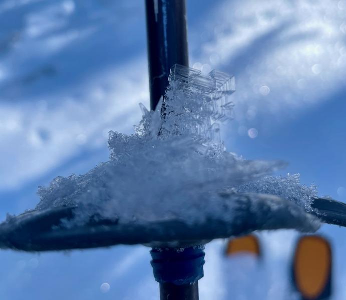
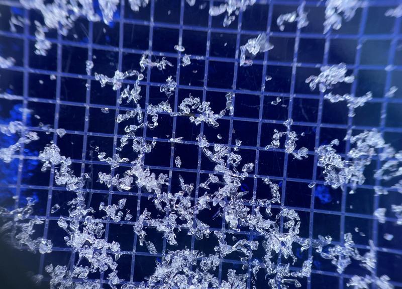
While it may seem like nothing is happening, a lot is happening within the snowpack. We are seeing a wide variety of snow surfaces, and layering within the snowpack. The cold and clear skies have not only promoted weakening in the upper layers of the snowpack through a process known as faceting, but these atmospheric conditions have been conducive for surface hoar, the wintertime equivalent of dew, deposition on many slopes. I use the word deposition with care: whereas faceting and weakening take place within the snowpack, surface hoar is deposited onto the snow surface. It all makes for soft, turnable snow now, once we get a large load of snow on top of it, the weak faceted snow and surface hoar often become a weak layer down the road.
Right now is an excellent opportunity to take note and begin mapping the variability and surfaces that are currently covering the range, as this will soon enough become the base of our snowpack for the season.
Photos of surface hoar (Gagne) and near-surface facets (Torrey) are below.


From Ogden to the central Wasatch to the Provo mountains, we have received several excellent observations. You can find them HERE. Please keep these excellent reports coming.
Recent Avalanches
A skier-triggered avalanche was reported on Sunday, 11/20 in Porter Fork. The avalanche was on a north aspect at 9,600', and involved loose dry faceted snow that failed 4" deep and 20' wide. The rider was knocked off their feet and caught and carried.
Ad
Avalanche Problem #1
Normal Caution
Type
Location
Likelihood
Size
Description
The current snowpack is generally stable and human-triggered avalanches are unlikely, but small avalanches in isolated areas are still possible.
  • We could see a few shallow dry loose avalanches in steep upper terrain where the eldest snow lingers.
  • With the elevated winds today into tonight you may be able to find an isolated pocket of wind-drifted snow in exposed, upper-elevation terrain. Pay attention to any signs of wind drifted snow such as rounded or pillow-shaped features.

Remember, even a small avalanche can be deadly in consequential terrain.
General Announcements

This information does not apply to developed ski areas or highways where avalanche control is normally done. This forecast is from the U.S.D.A. Forest Service, which is solely responsible for its content. This forecast describes general avalanche conditions and local variations always occur.