Holiday Auction is Live!

Forecast for the Salt Lake Area Mountains

Drew Hardesty
Issued by Drew Hardesty on
Wednesday morning, November 18, 2026

DANGEROUS AVALANCHE CONDITIONS EXIST.

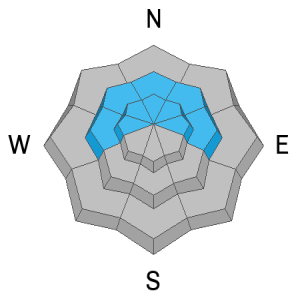
A CONSIDERABLE avalanche danger exists on steep northwest through east facing slopes in the higher elevation bands. You will be able to trigger soft slab avalanches both within the storm snow as well as more dangerous avalanches stepping down into early season weak sugary faceted snow. These avalanches will be up to 3 feet thick and you may trigger them at a distance.

Travel Advice: Stick to low angle terrain and be aware of overhead hazard. Be ready to assist with any rescue today.
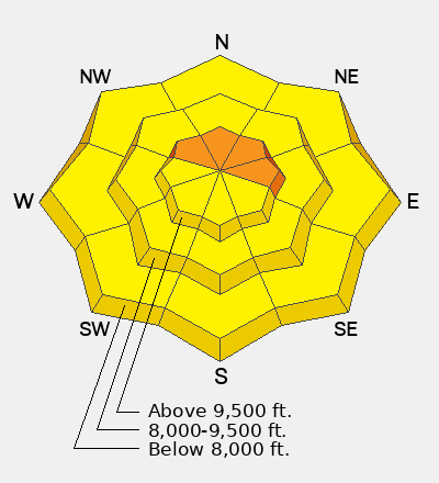
Low
Moderate
Considerable
High
Extreme
Learn how to read the forecast here
Special Announcements

***We will continue to issue danger ratings as conditions warrant.***

Each resort in Utah has its own uphill travel policies. Check out the summary of each resort's policy before traveling uphill. For further questions, contact the resort directly.

SAVE THE DATE!

Weather and Snow

Now THAT was a storm!

Moist unstable northwest flow are some of the sweetest words in weather.

Storm totals:

LCC: 16-20"/1.5-1.91" snow-water-equivalent

BCC: 12-14"

PC: 6-12"

Even some trailheads picked up 5-10" overnight.

Currently, skies are clear, winds are light to moderate from the west. Temperatures bottomed out into the single digits and teens.

For today, we'll see sunny skies with high cirrus moving in, hinting at the next storm. Temps will warm into the low 20s up high, the mid-30s down low. We'll see light to moderate winds from the west, increasing in speed this afternoon as they back to the southwest.

The next storm arrives tomorrow through Saturday which will bring another 12-18" of snow.

Recent Avalanches

Ski areas in the Cottonwoods reported some small natural avalanches triggered by the strong southerly winds yesterday. In the high elevation wind zone, I was experienced collapsing and shooting cracks 50' out from my skis. With the heavy snowfall and moderate to strong winds, I suspect the avalanche danger reached HIGH overnight in many areas.

You can find all recent observations HERE.

Avalanche Problem #1
Persistent Weak Layer
Type
Location
Likelihood
Size
Description

We have a classic early season structure of crusts and weak sugary faceted snow that has now been overloaded by heavy snowfall and wind. ALL the ingredients are now there for avalanches and ALL the ingredients are there for a hungry backcountry crowd to get into trouble. Today, you'll see avalanches, shooting cracks, and thunderous whumphs - all clear signs to avoid avalanche terrain. Because you can trigger avalanches at a distance, you may be able to trigger avalanches at a distance or from below.

The early season weak snow exists - conservatively - on westerly to northerly to easterly facing slopes above about 9000'. These will be the slopes to avoid for now.

Avalanche Problem #2
Wind Drifted Snow
Type
Location
Likelihood
Size
Description

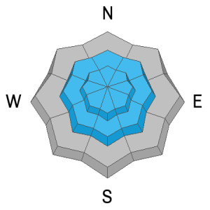
Moderate to strong winds preceded and then accompanied the heavy snowfall, particularly during frontal passage in the evening. Soft slabs of wind drifted snow may be found around the compass, but primarily in upper elevation north to east to southerly facing terrain.

Avalanche Problem #3
New Snow
Type
Location
Likelihood
Size
Description

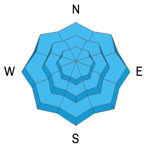
With such high snowfall rates, you may be able to trigger soft slabs and or loose snow sluffs in steep terrain on any aspect today, including some steep terrain in the lower elevation bands.

Additional Information

It's never too early to start thinking about avalanches. Here are a few things to consider doing:

  • Learn online. We have over 5 hours of free online learning at the Know Before You Go website
  • Check out the upcoming in-person Know Before You Go events HERE
  • Sign up for an on-snow class
  • Check out the UAC's education progression HERE
  • Get your avalanche rescue gear ready for winter. Put fresh batteries in your transceiver and update the firmware. Inspect your shovel and probe. Get your airbag backpack ready by possibly doing a test deployment and updating the firmware if it is an electric version or getting your canister refilled if it's not electronic.
General Announcements

This information does not apply to developed ski areas or highways where avalanche control is normally done. This forecast is from the U.S.D.A. Forest Service, which is solely responsible for its content. This forecast describes general avalanche conditions and local variations always occur.

Observations and Avalanches

Backcountry Emergency Procedures

SMS Notifications

Instagram

Facebook

Get Forecast Email

Previous Forecasts

Contact via email

Submit Observation