Forecast for the Salt Lake Area Mountains

Greg Gagne
Issued by Greg Gagne for
Saturday, January 9, 2021
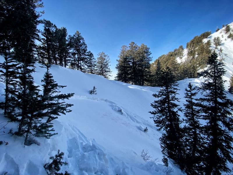
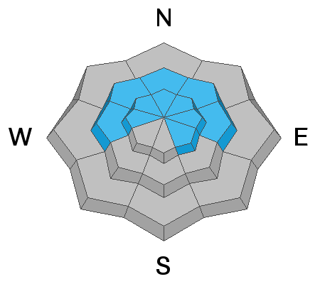
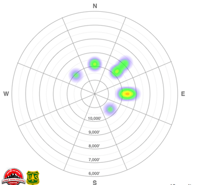
There is a CONSIDERABLE AVALANCHE DANGER on steep slopes at the mid and upper elevations facing west, through north, and east where recent storm snow and winds have created a dense slab of snow on top of a buried persistent weak layer. Avalanches may be 2-3' deep and over 200' wide. These are dangerous avalanche conditions - avoid being on, underneath, or adjacent to steep slopes on these aspects and elevations where human-triggered avalanches are likely. A Moderate danger exists for triggering a fresh wind drift at the upper elevations affected by the northeasterly winds.
Keep in mind:
- If you are leaving the ski area through an exit gate, you are entering the backcountry and likely stepping into a CONSIDERABLE avalanche danger.
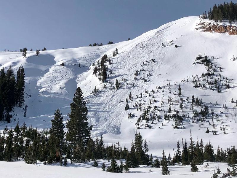
- Previous tracks on a slope are zero indication of stability. (Notice the tracks on the slope adjacent to the site of Friday's accident in Dutch Draw.)
- If you are skiing or riding alone, you have no margin of safety with no one to perform a rescue.
On Friday, I wrote, "There have been several close calls/near misses this past week and I am fearful our luck has run out." Indeed it has, and I wish I was wrong. Fortunately, excellent riding conditions exist on low-angled slopes other than due south.
Low
Moderate
Considerable
High
Extreme
Learn how to read the forecast here
Special Announcements
With great sadness, the Utah Avalanche Center reports that a 31-year old male snowboarder from Clinton, Utah was killed in a backcountry avalanche in Dutch Draw off of Silver Peak, located on the Park City Ridgeline.
The UAC, in partnership with Canyons Village ski patrol, will investigate the accident site today. Our thoughts go out to those affected by this tragic accident, especially the family and friends of the victim.
Out of respect for the victim and for the safety of those involved with the investigation, we ask that backcountry travelers avoid the Park City ridgeline above the Dutch Draw area as the investigation takes place today.


Thanks to the generous support of our local resorts, Ski Utah, and Backcountry, discount lift tickets are now available. Support the UAC while you ski at the resorts this season. Tickets are available here.
Weather and Snow
Skies are partly cloudy this morning with temperatures ranging through the teens. Winds are northerly and generally light - less than 10 mph - with gusts in the teens along the upper elevation ridges.
No new snow was reported overnight.
For today you can expect partly cloudy skies and continued light to moderate winds from the north and northeast, with gusts in the teens and low 20's mph. Temperatures will rise into the low 20's F.
No major storms are in sight.
Recent Avalanches
The Dutch Draw avalanche accident occurred on an east aspect at 9800'. The slide was 1-2' deep, about 200' wide, and ran 700' vertical, failing in weak faceted snow. A preliminary report has been published, and we will fill in more details after the investigation of the accident site today.
There was also another human-triggered avalanche on Friday in Main Porter Fork in Millcreek Canyon. This was on a north aspect at 9500' and was 1.5' deep and 60' wide, with debris piling up 5-6' against trees. Once again, failing in weak faceted snow. Those involved with this slide called it "a near miss" and "a small change [in how we managed the terrain] could have resulted in my partner or me [being involved in] a consequential slide."

Our Week in Review - where we highlight significant weather and avalanche events from this past week - has been published. (It's good reading to get a handle on the significant number of avalanche events that have occurred over this past week.)
Ad
Avalanche Problem #1
Persistent Weak Layer
Type
Location
Likelihood
Size
Description
Recent avalanches are the greatest indication of avalanche danger. More than 20 human-triggered avalanches failing in the buried persistent weak layer (PWL) have been reported to the UAC since January 1, now with one fatality. Many avalanches have been triggered remotely, over 3' deep and over 150' wide. (Thursday's Martha's Bowl slide was reported at 300' wide.) Recent storm snow and moderate to strong winds have built a dense slab on top of this PWL creating dangerous avalanche conditions. You simply need to avoid steep terrain facing west, through north, and east at the mid and upper elevations.
A heat map of the distribution of avalanche activity (almost all avalanches failing in the PWL) in the Salt Lake mountains since the start of the New Year:
If you choose to enter the terrain where this PWL exists, stick to low-angled slopes (less than 30° in steepness) with nothing steep adjacent to or above you.
Additional Information
A few years ago Drew did an analysis of the avalanches in the state of Utah in the modern era. This is for the post-mining days. We're up to 123 fatalities since January 1940.
The last sentence in the study's introduction was this -
As with any papers looking at statistics, it might be tempting to look at these fatalities as just numbers. But at the end of the day, each incident is not a number at all. Each incident is a human being – a person with a family and a community, with dreams and aspirations whose life was taken from them by an avalanche.
General Announcements
Please visit this website with information about Responsible Winter Recreation by the Utah Office of Outdoor Recreation.

This information does not apply to developed ski areas or highways where avalanche control is normally done. This forecast is from the U.S.D.A. Forest Service, which is solely responsible for its content. This forecast describes general avalanche conditions and local variations always occur.