Forecast for the Salt Lake Area Mountains

Trent Meisenheimer
Issued by Trent Meisenheimer on
Sunday morning, January 10, 2021
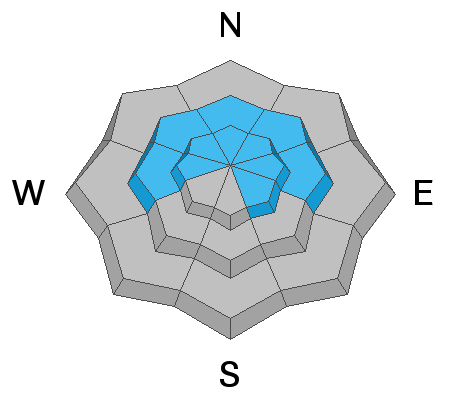
There is a CONSIDERABLE AVALANCHE DANGER on steep slopes at the mid and upper elevations facing west, through north, and east where recent storm snow and winds have created a dense slab of snow on top of a buried persistent weak layer.
Avalanches may be 2-3' deep and over 200' wide. These are dangerous avalanche conditions - avoid being on, underneath, or adjacent to steep slopes on these aspects and elevations where human-triggered avalanches are likely.
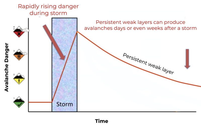
If you are exiting a resort boundary and entering the backcountry, you are likely stepping into a CONSIDERABLE AVALANCHE DANGER where dangerous avalanches can be triggered.
Low
Moderate
Considerable
High
Extreme
Learn how to read the forecast here
Special Announcements
With great sadness, the Utah Avalanche Center reports that a 31-year old male snowboarder from Clinton, Utah, was killed in a backcountry avalanche in Dutch Draw off of Silver Peak, located on the Park City Ridgeline. The preliminary report can be found HERE.
UAC Staff, along with PCMR Ski Patrol, investigated the accident yesterday and will have the full report available in a couple of days.
Weather and Snow
High pressure is building in from the west resulting in stable and dry conditions. Current mountain temperatures are in the mid-teens °F above 9,000' while lower in the canyon; the temperatures are in the single digits. Winds are calm with ridgetop speeds of 5-10 mph from the north.
Today, there will be sunny skies up high with some clouds at the mid-elevations. Temperatures will warm into the mid 20's °F at 9,000'. Soft settled powder exists on the compass's shady half while the southerly facing terrain will be crusted this morning before softening by mid-afternoon.
Recent Avalanches
Yesterday there were three new avalanches reported to the UAC. Bringing the total number of human triggered avalanches from the past week to twelve. We've had many close calls and one fatality. Most of these avalanches have been 1.5' - 2.5' deep and up to 175' wide, failing on weak faceted snow in the snowpack.
  • Pioneer Bowl: North facing at 9,800' and was 16" deep by 100' wide (nobody caught)
  • Ant Knolls: North facing at 9,400' and was 2.5' deep by 150' wide (skier triggered, nobody caught)
  • Silver Fork: Northeast facing at 9,000' and was 16" deep by 30' wide (nobody caught)

Our Week in Review - where we highlight significant weather and avalanche events from this past week - has been published. (It's good reading to get a handle on the significant number of avalanche events that have occurred over this past week.)
Ad
Avalanche Problem #1
Persistent Weak Layer
Type
Location
Likelihood
Size
Description
Persistent Weak Layers (PWL) are defined as follows: This avalanche problem is related to persistent weak layers buried in the snowpack. Release a cohesive layer of soft to hard snow (a slab) in the snowpack when the bond to an underlying layer fails and releases an avalanche. These weak layers typically include buried surface hoar, depth hoar, and faceted crystals.
In simple terms - we have buried weak faceted snow with a stronger, more dense layer of snow on top (this creates the problem). If you decide to ride slopes greater than 30° degrees in steepness (avalanche terrain), you are messing with a very dangerous avalanche problem. Below are a few things to keep in mind when dealing with a PWL.
  • Responsible for roughly 70% of all avalanche fatalities
  • Avalanches can be triggered from a distance.
  • Can be triggered days, weeks, or months after being buried
  • Tracks are not a sign of stability, and you can still trigger the avalanche even though the slope is tracked up.
Travel Advice: Avoid steep northerly facing terrain that is greater than 30° in steepness. Make sure nothing is steep above or adjacent to you as you travel as avalanche can be triggered from a distance. Personally, I am not messing with this terrain at all. I will be riding or walking in low angle terrain for the foreseeable future.
The image below shows that the danger stays elevated for many days after a loading event when dealing with persistent weak layers.
General Announcements
Please visit this website with information about Responsible Winter Recreation by the Utah Office of Outdoor Recreation.

This information does not apply to developed ski areas or highways where avalanche control is normally done. This forecast is from the U.S.D.A. Forest Service, which is solely responsible for its content. This forecast describes general avalanche conditions and local variations always occur.