Special Avalanche Bulletin
What
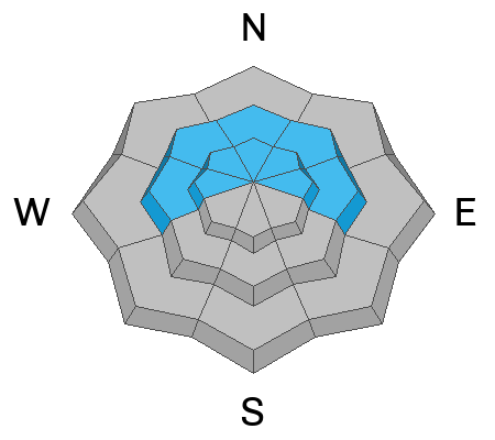
The Utah Avalanche Center is warning of dangerous avalanche conditions throughout the mountains of northern Utah this week, where heavy snowfall and strong winds have created a CONSIDERABLE avalanche danger. Large and unsurvivable tree snapping avalanches 4-6 feet deep have already occurred, multiple riders have been critically buried in an avalanche in the Brighton backcountry since Friday, and more human-triggered avalanches are expected, with natural avalanches possible.
When
In effect from 6AM MST today to 6AM MST Wednesday
Where
For the mountains of Northern Utah, including the Wasatch Range...Uinta Mountains.
Impacts
Dangerous avalanche conditions exist on many slopes. Avalanches are likely to be triggered by anyone traveling on or below slopes steeper than 30 degrees and may be triggered remotely (from a distance) or from below. People stepping out of bounds at a ski area are stepping into the same dangerous avalanche conditions.
Be mindful of avalanche workers - IF YOU TRIGGER an avalanche near a ski area, please report it to the ski patrol dispatch or Alta Central (801-742-2033). Rescue personnel don’t want to be subjected to dangerous conditions if the scene is clear. More on this in Backcountry Emergency Protocols
This morning, skies are clear, and the storm appears to have exited the region. Winds are out of the west southwest and sustained, averaging in the teens and 20s mph (prime speeds for building fresh wind drifts), with gusts in the 30s mph along exposed mid and upper elevation ridgelines. Gusts at 11,000 feet are reaching the 50s mph. Temperatures range from the upper teens to low 20s °F.
As of 5 AM, final storm snow water equivalent totals (in inches) include:
→ Little Cottonwood: 29" / 3.84"
→ Big Cottonwood: 31" / 3.23"
→ Park City Ridgeline: 21" / 1.7"
Today will shape up to be a beautiful day in the mountains, with sunny skies and occasional high clouds. Temperatures will climb into the low 30s °F. Winds will continue to blow from the west southwest, averaging 10–15 mph along exposed mid and upper elevation ridgelines, with gusts up to 35 mph near 11,000 foot ridgelines.
After a brief lull, another storm is expected later Wednesday. This looks to be a more traditional system, bringing colder temperatures and lower density snowfall. Confidence is high for snow along and just behind the cold front, though remaining uncertainties in storm timing and density will ultimately shape final snowfall and SWE totals. Current projections range from 8 to 24 inches of snow, with up to 1.5 inches of water.
Yesterday, six avalanches were reported in the mountains around the Salt Lake City area. Out of those six, two were clear standouts, both failing deeper and producing large debris piles.
Aside from those two, the remaining reports were primarily shallow new snow or wind-drifted avalanches.
- Twin Lakes Pass: Soft slab, natural triggered, 8" deep, 50' wide
- Two Trees: Soft slab, natural triggered, 5" deep, 15' wide
- Gods Lawnmower: Soft slab, natural triggered, 12" deep, 100' wide
- Superior: Dry loose, depth unknown, 45' wide
On Sunday afternoon, a party on the ridgeline above Two Dogs in Days Fork accidentally dropped a cornice onto the slope below, triggering a large avalanche. The slide failed above the Christmas rain crust, then stepped down to facets and depth hoar at the ground. It broke on a northeast aspect near 10,100 feet, was 4.5' deep, 250' wide, and ran about 700', snapping trees along the track. Yesterday, Bo and I checked out the avalanche, which had nearly filled back in by the time we arrived. Our full observation is posted HERE.
Read all backcountry observations here.