31st Annual Backcountry Benefit - September 12th - Tickets Available Here!

Forecast for the Salt Lake Area Mountains

Nikki Champion
Issued by Nikki Champion on
Wednesday morning, January 5, 2022
Heavy snowfall, high winds, and warm temperatures will cause the avalanche danger to rise to HIGH. Pay attention to changing weather - avalanche danger will increase as this storm intensifies.
Natural and human-triggered avalanches are likely. Even unusual avalanches are possible in atypical terrain on atypical aspects and elevations.
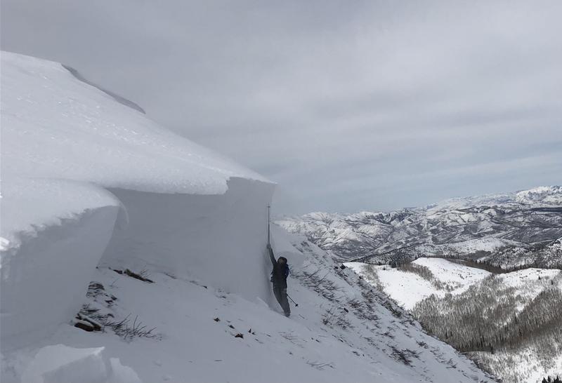
Today, there are three avalanche problems to watch for: (1) triggering a slab avalanche 4-6' deep in the weak faceted snow, (2) sluffing and soft slab avalanches within the new snow, and (3) both soft and hard slabs of wind drifted snow that would likely steep down into the weak snow below.
What to do? The only viable strategy today is to ride slopes less than 30 degrees in slope steepness, well out from under, and not connected to slopes steeper than about 30 degrees.
Low
Moderate
Considerable
High
Extreme
Learn how to read the forecast here
Avalanche Warning
What
HEAVY DENSE SNOW ALONG WITH STRONG WINDS AND POTENTIAL FOR RAIN-ON-SNOW AT LOW ELEVATIONS WILL CREATE DANGEROUS AVALANCHE CONDITIONS AND A HIGH AVALANCHE DANGER.

When
IN EFFECT FROM 6 AM MST THIS MORNING TO 6 AM MST THURSDAY

Where
ALL THE MOUNTAINS OF NORTHERN AND CENTRAL UTAH, INCLUDING THE BEAR RIVER AND WASATCH RANGE, AND THE WESTERN UINTAS.

Impacts
NATURAL AND HUMAN-TRIGGERED AVALANCHES WILL BE LIKELY ON MANY ASPECTS AND ELEVATIONS.

Warning Times
Wednesday, January 5, 2022 - 6:00 am to Thursday, January 6, 2022 - 6:00 am
Weather and Snow
This morning, temperatures are in the mid-20s F and rising. Overnight, west-southwesterly winds remained elevated at mid-elevation bands, they are currently blowing 20-30 mph gusting 40 mph. At the upper elevation ridgelines, they are gusting near 50 mph. Light snowfall began last night, with snowfall totals between 2-4" so far.
Today, temperatures will continue to increase to the upper 20s and mid-30s F. Snowfall should begin to ramp up this morning, with periods of heavy snowfall, up to 2" snow/hour. This snowfall should continue through Thursday afternoon. We can expect an additional 12-18" of new snow of the ground by sunset tonight. Throughout this storm, temperatures will continue to rise, and with that the snow line should be rising from approx 6000' to 7000'. That could mean we see some periods of rain on snow at low elevations. Winds will bump up again late this morning, and early this afternoon. The winds will blow 20-30 mph, with gusts up to 45 mph at mid-elevations. At upper elevations, gusts may reach up to 70 mph.
This wet, warm, and windy storm could bring 20-34" of snow (2.0 - 3.0 H2O) to the range by Friday morning.
Recent Avalanches
Yesterday, there were no new avalanches reported in the backcountry, but reports from avalanches triggered this past weekend continue to roll in.
View all the recent avalanche activity HERE.
On Monday, we went out and looked at the remotely triggered avalanche on the Firewater Run of Little Water Peak. This avalanche failed deeply on a layer of facets above a crust, and then stepped down to the ground in many places. Below shows the crown depth at one of it's deepest points, close to 12', while the average depth was closer to 4'. Find the full observation here.
Ad
Avalanche Problem #1
Persistent Weak Layer
Type
Location
Likelihood
Size
Description
The situation is very simple - there is a persistent weak layer (PWL) of old, faceted snow near the ground with 3-10 feet of snow on top of it. This layer has been fracturing and producing large and destructive avalanches over the past week. This morning we are adding two huge stressors to this fragile snowpack in the form of heavy wet snowfall and elevated winds. We can't know if this will be the tipping point that will cause the snowpack to become unglued, but we do know that the avalanche danger and likelihood of avalanches will be on the rise again.
This layer exists on west, north, and east-facing slopes where old snow lingered and weakened in November and was buried by December snowfall. It doesn't exist on south-facing slopes because it melted away in November, and December snowfall landed on bare ground on those slopes. The most likely places to trigger a slide in that persistent weak layer are slopes with some wind-loading especially on more northerly facing slopes with the weakest snow.

Today, human-triggered avalanches will become very likely, these avalanches can be large enough to catch, carry, bury, and kill a person. Given the new snowfall, elevated winds, and poor snowpack structure I would avoid any terrain steeper than 30 degrees, with any steep terrain above or attached to it. Today is not the day to push it.
Avalanche Problem #2
New Snow
Type
Location
Likelihood
Size
Description
With warm, wet snow on the way - new snow avalanches will become possible on all aspects and elevations and will likely get bigger and more active over the next few days. Extreme caution is required. Today we should be getting 12-18" of new snow, and up to 34" of snow by the time this is all said and done. While snow totals are important, what we truly pay attention to is what RATE that snowfalls and how quickly it loads the snowpack. We call this precipitation intensity, and if those rates stay elevated or increase throughout the morning we could see the avalanche danger spike and more new snow avalanches occurring. Keep an eye on the sky, if the snow rate rapidly increases you know the danger is on the rise.
During these times of high precipitation intensity, both fast-running sluffs and soft slab avalanches will be possible. These human-triggered or natural soft slab avalanches may even step into the old-faceted snow producing significantly larger avalanches.

With such warm temperatures, there could be periods over the next few days that we may get rain on snow at lower elevations. Know that rain on snow is always a red flag and danger will spike in those areas. If you are getting rained on, it might be a good sign to go seek other terrain options.
Avalanche Problem #3
Wind Drifted Snow
Type
Location
Likelihood
Size
Description
The winds have been cranking now for multiple days. These strong winds in combination with a few inches of new snow will have drifted snow and formed fresh slabs. The issue with yesterday's freshly formed wind slabs is they will likely be hidden under a few inches of new snow from this morning and will be harder to identify.
Know that slabs of wind drifted snow will exist on mid and upper elevation terrain features that snow could be deposited, such as ridgelines and gullies.
This afternoon's elevated winds in combination with new snow will continue to form both soft and hard slab avalanches in mid and upper elevation wind drifted terrain. As the winds continue to blow, these slabs will become more firm and cohesive. This can allow you to travel out farther onto the slope before it breaks, and can fail larger and wider than expected. High winds can deposit snow on all aspects but give west through north through east extra caution, as triggering an avalanche that initially fails in the wind-drifted snow will likely break down more deeply into the weak faceted snow below.
General Announcements
Who's up for some free avalanche training? Get a refresher, become better prepared for an upcoming avalanche class, or just boost your skills. Go to https://learn.kbyg.org/ and scroll down to Step 2 for a series of interactive online avalanche courses produced by the UAC.
This information does not apply to developed ski areas or highways where avalanche control is normally done. This forecast is from the U.S.D.A. Forest Service, which is solely responsible for its content. This forecast describes general avalanche conditions and local variations always occur.