Forecast for the Salt Lake Area Mountains

Drew Hardesty
Issued by Drew Hardesty on
Thursday morning, January 6, 2022
A HIGH AVALANCHE DANGER EXISTS ON THE MID AND UPPER ELEVATION WEST TO NORTH TO EAST FACING TERRAIN. A CONSIDERABLE DANGER EXISTS ON MANY OTHER SLOPES, EVEN AT THE LOWER ELEVATION BANDS.
You can easily trigger dangerous new snow and wind slab avalanches today that may also step down 3-10' into older weaker layers in the snowpack.

The GOOD NEWS is that excellent and safe riding can be found on low angle slopes with no overhead hazard today.
Low
Moderate
Considerable
High
Extreme
Learn how to read the forecast here
Avalanche Warning
What
HEAVY DENSE SNOW ALONG WITH STRONG WINDS AND RAIN-ON-SNOW AT LOW ELEVATIONS HAS CREATED DANGEROUS AVALANCHE CONDITIONS AND A HIGH AVALANCHE DANGER.

When
IN EFFECT FROM 6 AM MST THIS MORNING TO 6 AM MST FRIDAY
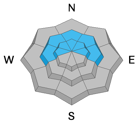
Where
ALL THE MOUNTAINS OF NORTHERN AND CENTRAL UTAH, INCLUDING THE BEAR RIVER AND WASATCH RANGE, AND THE WESTERN UINTAS.

Impacts
NATURAL AND HUMAN-TRIGGERED AVALANCHES WILL BE LIKELY ON MANY ASPECTS AND ELEVATIONS.
Weather and Snow
Skies are overcast, if not obscured altogether as we see the last bit of snowfall through the morning hours. The Central Wasatch mountains picked up an additional 2-4" (0.5-0.7"Snow-Water-Equivalent) overnight. Storm totals are below.
LCC: 17"/3.12" SWE
BCC: 16"/2.40" SWE
Park City areas: 14"/2.02" SWE
Ogden areas: 19"/2.93" SWE
Provo areas: 12"/2.99" SWE
Unfortunately, the rain/snow line reached 7000' yesterday. (There were some reports of a rain/drizzle crust up to 8000'.)
Overnight gusts from the west exceeded 100mph at the 11,000' level and winds remain moderate to strong even at the mid-elevations.
Temperatures continue to warm into the upper 20s and low 30s.
For today, we may squeeze another few inches of heavy dense snow out of the last vestiges of the storm before high pressure builds in - albeit briefly - from the west. Mountain temperature will be in the upper 20s to low 30s. Winds will be moderate from the west. Mountain temperatures will continue to warm into the mid to upper 30s on Friday. Look for some clearing tonight and tomorrow ahead of another storm Friday evening into Saturday. This will usher in another few inches of snow and cooler temps.
Recent Avalanches
Ski area avalanche teams reported widespread sensitive new snow and wind slab avalanches roughly 1-2' deep at the mid and upper elevations. Backcountry observers reported much the same.
View all the recent avalanche activity HERE.
On Monday, Nikki and her partners went out and looked at the remotely triggered avalanche on Little Water Peak. This avalanche failed deeply on a layer of facets above a crust, and then stepped down to the ground in many places. The crown depth at one of it's deepest points was close to 12', while the average depth was closer to 4'. I would not be surprised to hear about more of these that occurred yesterday, overnight and possibly today.
Ad
Avalanche Problem #1
Persistent Weak Layer
Type
Location
Likelihood
Size
Description
The situation is very simple - there is a persistent weak layer (PWL) of old, faceted snow near the ground with 3-10 feet of snow on top of it. This layer has been fracturing and producing large and destructive avalanches over the past week. We have adding two huge stressors to this fragile snowpack in the form of heavy wet snowfall and significant wind loading.
This layer exists on west, north, and east-facing slopes where old snow lingered and weakened in November and was buried by December snowfall. It doesn't exist on south-facing slopes because it melted away in November, and December snowfall landed on bare ground on those slopes. The most likely places to trigger a slide in this persistent weak layer are slopes with some wind-loading especially on more northerly facing slopes with the weakest snow.

Given the new snowfall, elevated winds, and poor snowpack structure I would continue to avoid being on or beneath any steep west to north to east facing terrain.
Avalanche Problem #2
Wind Drifted Snow
Type
Location
Likelihood
Size
Description
Significant wind loading continued overnight and will continue throughout the morning. These wind drifts may be up to 2-3' deep and sensitive to the weight of skis or a sled in steep terrain. These drifts may be found on all aspects at the mid and upper elevations, but more pronounced on north to east to south facing terrain. Note that shooting cracks are a clear sign of instability.
Avalanche Problem #3
New Snow
Type
Location
Likelihood
Size
Description
New snow avalanches will remain sensitive in steep terrain at the mid and upper elevations on all aspects. New snow avalanches yesterday failed both within the new snow and at the new/old interface.

Due to the rain/snow line reaching or exceeding 7-7500', human triggered wet snow avalanches will be likely in the lower elevation bands, particularly on the shady aspects. Wet loose debris may pile up deeply in terrain traps.
Also, AVOID the ice climbing terrain until we see cooler weather. Wet avalanches may funnel down the ice gullies.
ROOF-alanches also continue to be a concern below the rain/snow line.
General Announcements
Who's up for some free avalanche training? Get a refresher, become better prepared for an upcoming avalanche class, or just boost your skills. Go to https://learn.kbyg.org/ and scroll down to Step 2 for a series of interactive online avalanche courses produced by the UAC.
This information does not apply to developed ski areas or highways where avalanche control is normally done. This forecast is from the U.S.D.A. Forest Service, which is solely responsible for its content. This forecast describes general avalanche conditions and local variations always occur.