Forecast for the Salt Lake Area Mountains

Trent Meisenheimer
Issued by Trent Meisenheimer for
Saturday, January 30, 2021
The avalanche danger is HIGH on upper elevation aspects facing northwest, through north, and southeast. Upper elevation aspects facing south, southwest, and west - and all mid-elevation aspects - have a CONSIDERABLE danger. Additional new snow and recent strong southerly winds have overloaded the snowpack on many slopes at the mid and upper elevations. Any natural or human-triggered avalanche can be 2-4' deep and over a few hundred feet wide and likely unsurvivable.
TRAVELING IN AVALANCHE TERRAIN IS NOT RECOMMENDED.

If you're leaving a resort boundary through an exit point, you are stepping into CONSIDERABLE or HIGH avalanche danger.
Low
Moderate
Considerable
High
Extreme
Learn how to read the forecast here
Special Avalanche Bulletin
IN EFFECT FROM 6 AM MST THIS MORNING TO 6 AM MST SUNDAY
FOR THE MOUNTAINS OF NORTHERN UTAH INCLUDING THE WASATCH RANGE...BEAR RIVER RANGE...UINTA MOUNTAINS...
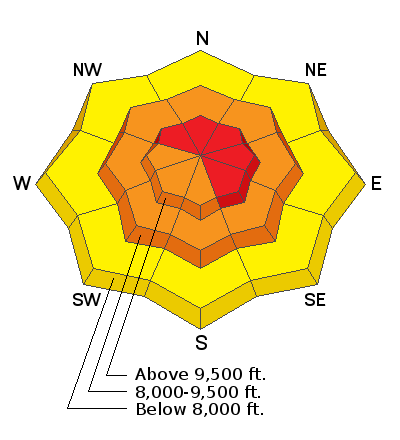
THE AVALANCHE DANGER IS CONSIDERABLE TO HIGH IN MANY AREAS.
CONDITIONS ARE PERFECT FOR AVALANCHE ACCIDENTS THIS WEEKEND. DANGEROUS AVALANCHE CONDITIONS EXIST. AVALANCHES COULD BE LARGE, VERY DANGEROUS, UNEXPECTED, AND PERHAPS DEADLY.
Weather and Snow
WHAT A STORM! snow totals are impressive from the past 24hrs. As the storm exits to our east, the winds veered to the northwest and have finally calmed down to more reasonable speeds. The wind is currently blowing from the northwest at speeds of 10-15 mph, gusting into the 20's across the upper elevation terrain. The cold front overnight ushered in colder temps, and mountain stations record temperatures in the teens to low 20's °F.
The snow will begin to taper off by late morning as high pressure builds in for the weekend leading to clearing skies. The good news is this high pressure is short-lived, and we return to an active pattern by mid-week. Rough snow totals are as follows:
Upper LCC: 15"-18" new snow (1.0 "-1.15" water)
Upper BCC: 12"-19" new snow (0.75"-1.15" water)
Park City Ridge: 10"-12" new snow (0.80"-1.0" water)
Provo Mountains: 10"-12" new snow (1.0"-1.51" water)
Ogden Mountains: 10"-15" new snow (0.95"-1.31" water)

Week in Review: This past week has been active with lots of (1) snow, (2) wind, and (3) avalanches. Catch up by reading our latest Week in Review.
Recent Avalanches
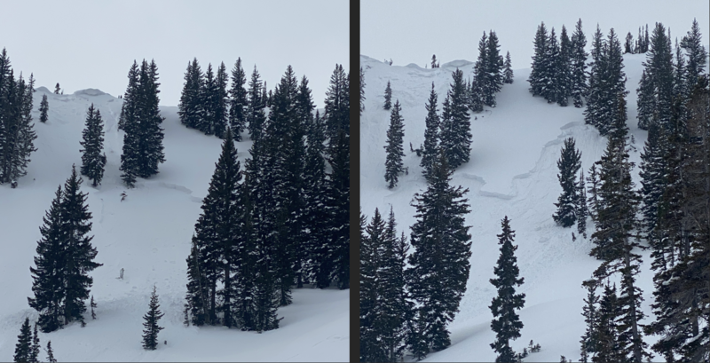
Yesterday there was a report of a significant natural avalanche from the Silver Fork Headwall that was roughly 3' deep and 150' wide. Snow safety teams continue to produce large results with explosives and avalanches are breaking down to the ground in uncompacted terrain.
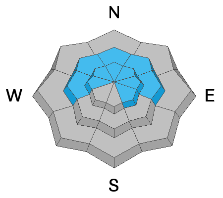
Overnight, Upper Little Cottonwood Canyon went through a natural new snow avalanche cycle on the steep southerly facing terrain. The avalanche list is growing, and as always, you can find all observations and recent avalanches HERE.
Ad
Avalanche Problem #1
Persistent Weak Layer
Type
Location
Likelihood
Size
Description
Recent strong southerly winds from the past three days have blown and drifted snow onto many slopes at the mid and upper elevations. These winds, along with the additional weight of the new snow, have stressed our weak and faceted snowpack to the breaking point.
The snowpack is starting to show its cards and is now producing deep and dangerous avalanches that are breaking 2'-4' deep and hundreds of feet wide. In some areas where the wind has been non-stop and loading the slope for days, the avalanche is breaking 5'-10' feet deep to the ground. These avalanches are likely to be unsurvivable.
Bottom Line: Our snowpack is a junk show and shouldn't be messed with right now. There is no outsmarting this problem - avoidance is the answer. If you're heading out into the backcountry today, be sure to stick to terrain that's under 30° degrees in slope steepness with nothing steep above or adjacent to you. Avalanche can be triggered from a distance. Traveling in avalanche terrain is NOT recommended.
Photo: Hughes - Silver Fork Headwall. This is a prime example of the type of avalanche that humans are likely to trigger in steep terrain today.
Avalanche Problem #2
New Snow
Type
Location
Likelihood
Size
Description
In the past 24 hrs, we've stacked up 10"-20" of new snow across the range. Overnight some steep southerly terrain went through a natural avalanche cycle within the new snow. Today, I would expect long-running sluffs and or soft slab avalanches that can fail within the new storm snow. In my mind, this problem is just shadowing the true killer, which is the persistent weak layer. Any new snow avalanche triggered might be enough to step down into deeper weaker layers.
General Announcements
Please visit this website with information about Responsible Winter Recreation by the Utah Office of Outdoor Recreation.

This information does not apply to developed ski areas or highways where avalanche control is normally done. This forecast is from the U.S.D.A. Forest Service, which is solely responsible for its content. This forecast describes general avalanche conditions and local variations always occur.