Forecast for the Salt Lake Area Mountains

Greg Gagne
Issued by Greg Gagne for
Friday, January 3, 2020
The avalanche danger is CONSIDERABLE on all aspects at the upper elevations, and at mid-elevations on aspects facing northwest, through northeast, and southeast where human-triggered avalanches are likely on steeper, wind-drifted slopes. Avalanches on wind-drifted slopes may be triggered from below or on adjacent slopes. The avalanche hazard is Moderate on mid-elevation aspects facing south through west, and all low elevation aspects.
Low
Moderate
Considerable
High
Extreme
Learn how to read the forecast here
Special Announcements
Get discount lift tickets HERE. Thanks for this generous support from Utah Ski Resorts and Ski Utah. All proceeds go directly to supporting the UAC.

New to the backcountry or in need of a refresher? Consider taking a companion rescue course offered at Woodward Park City, January 14, 5:30-9 p.m.
Weather and Snow
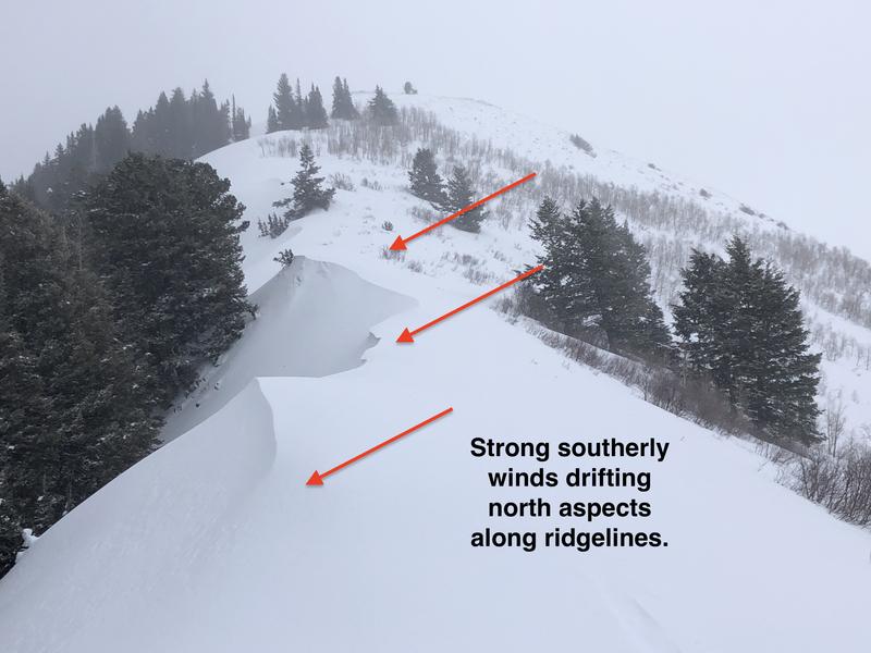
Currently, mountain temperatures are in the upper teens F. A trace to 2" of snow has fallen since Thursday afternoon. Winds are out of the west/northwest and wind speeds are very elevation-dependent. At 11,000' winds are averaging in the 30's mph, with gusts in the 40's and 50's mph. But drop elevation and wind speeds diminish, averaging in the teens with gusts in the 20's mph.
Storm totals from the New Years storm include:
- Park City Ridgeline 9" snow with 1" water
- Upper Big Cottonwood 18" snow with 1.8" water
- Mid Big Cottonwood 10" snow with 1" water
- Little Cottonwood 22" snow with 2.5" water
For today, expect partly cloudy skies with gradual clearing as high pressure briefly moves into our region. Temperatures will warm into the 20's and low 30's F. Winds will be out of the northwest remain strongest at the upper elevations, gusting into the 40's mph at 11,000'. Drop elevation and wind speeds will be much more moderate, with exposed ridges averaging in the teens with gusts in the 20's mph.

Our Week In Review which summarizes the weather and avalanche activity for this past week has been published.
Recent Avalanches
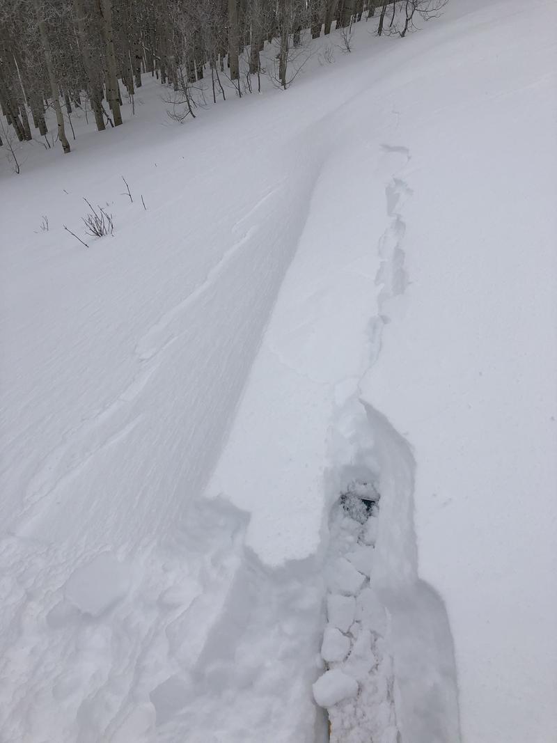
Three remotely-triggered slides were reported from the backcountry on Thursday:
- Butler Fork 9300' N aspect 12" deep 30' wide running an estimated 150-200' (observation)
- Tuscarora 10,400 SE aspect 14" deep 40' wide (observation)
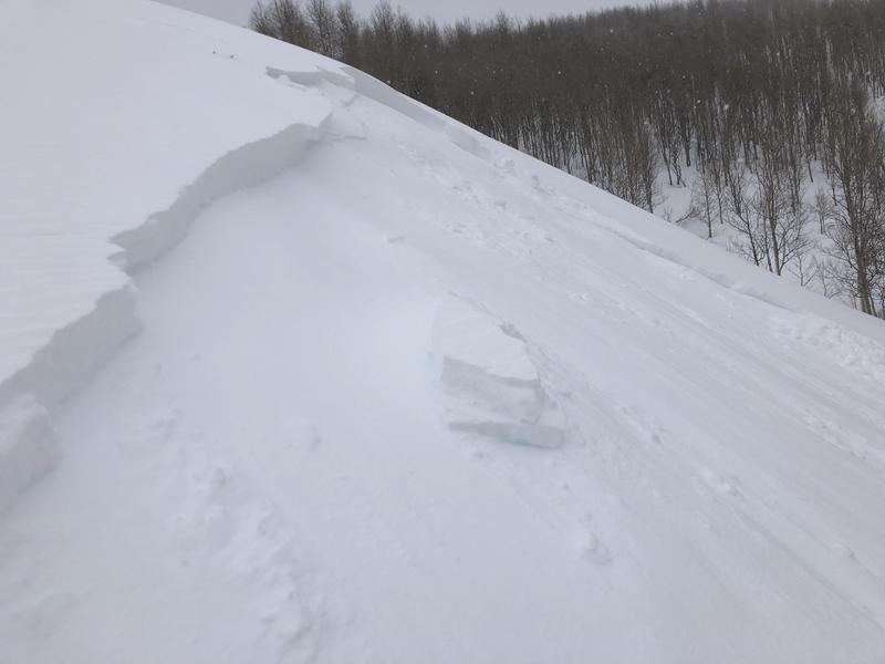
- Little Water Peak 9300' SE aspect 12-16" deep 60' wide running 250' vertical [photo below] (observation)
These avalanches were on wind-loaded slopes, failing at the new snow/old snow interface.
Check out all of our observations HERE.
Ad
Avalanche Problem #1
Wind Drifted Snow
Type
Location
Likelihood
Size
Description
Westerly winds the past several days continue to drift snow onto many mid and upper elevation slopes. Although you can expect to find fresh wind drifts on leeward aspects generally facing east, the wind can work through terrain and cross-load a slope on any aspect. The three remotely-triggered slides on Thursday are an indication these wind drifts will continue to be reactive today. Avoid wind-drifted slopes as avalanches can be triggered from below or on an adjacent slope. Watch for clues of wind loading such as cracking and wind-drifted pillows.
Longtime UAC observer and educator Cody Hughes wrote in his excellent observation from yesterday "find the wind find the avalanches", and most observations indicate that recent avalanche activity requires a wind-drifted slope. But in areas that have received the most storm snow (i.e. upper Big and Little Cottonwood canyons), you may still find sensitive storm slabs up to 12-18" thick resting on the weaker snow surface that existed prior to the New Years storm. Signs to watch for include cracking and collapsing.
Mark White has an excellent observation from Thursday where he describes how you can identify this setup of a storm slab over weaker snow, as well as his advice for avoiding these slopes until they stabilize.
Avalanche Problem #2
Persistent Weak Layer
Type
Location
Likelihood
Size
Description
This layer has been mostly dormant and has been gaining strength, but it is not forgotten. This New Years storm which included strong winds and snowfall with over 2" of water weight in some areas is a good test for the stability of this weak layer. It is possible this load may stress the snowpack in some areas, and that avalanches may step down into this persistent weak layer down near the ground. This weak snow can be found at the mid and upper elevations, on aspects facing northwest, through north, and east.
Avalanching on this layer is most likely on repeater avalanche paths, generally shallower snowpacks, and in steep thin rocky terrain.
General Announcements
This information does not apply to developed ski areas or highways where avalanche control is normally done. This forecast is from the U.S.D.A. Forest Service, which is solely responsible for its content. This forecast describes general avalanche conditions and local variations always occur.