Forecast for the Salt Lake Area Mountains

Nikki Champion
Issued by Nikki Champion on
Tuesday morning, January 26, 2021
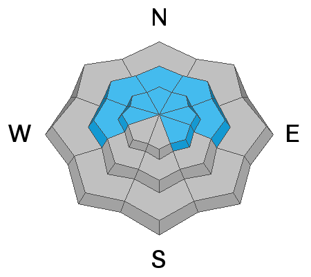
The avalanche danger is CONSIDERABLE on all steep slopes at the upper elevations, where human-triggered slab avalanches are likely. The avalanche danger is also CONSIDERABLE on mid-elevation steep slopes facing west, through north, through east. We have dangerous avalanche conditions, and conservative decision-making will be essential today. Slab avalanches 1-3 feet deep hundreds of feet wide are likely. These are unsurvivable avalanche conditions. Low angle terrain continues to be your best option.

All other aspects have a MODERATE avalanche danger.
If you're leaving a resort boundary through an exit point, you are stepping into CONSIDERABLE avalanche danger.
Low
Moderate
Considerable
High
Extreme
Learn how to read the forecast here
Special Announcements
SPECIAL NOTE: HALF OF ALL SKIER/SNOWBOARDER FATALITIES SINCE 99/00 HAVE OCCURRED WITH PEOPLE GOING OUT OF BOUNDS AT A SKI AREA.
Weather and Snow
This morning, skies are overcast and it is lightly snowing. The Southeasterly winds are still light but have begun to pick up overnight averaging 10-20 mph and gusting up to 35 mph at ridgelines. Mountain temperatures are in the single digits to low teens.
Today, skies will be mostly cloudy with isolated snow showers and minimal accumulation, less than 2 inches. Winds will ramp up and becoming Southwesterly throughout the day and into the afternoon. Winds will average 15-25 mph, with gusts up to 40 mph at the highest ridgelines. Temperatures will rise into the low-20s F.
The Outlook:
A southwest flow is setting up well to the west of us will pummel us by strong southwest winds over the next few days. It eventually ejects inland and moves overhead Friday into the weekend.
Recent Avalanches
Yesterday, we received 3 new avalanche reports from the backcountry:
  • Murdock Peak - 9,100' - NW Aspect - multiple remotely triggered avalanches on the Millcreek/Lambs Ridgeline - All were triggered from 50'-250' away, were 2-3' deep, and ranged from 60'-120' wide - failed on the old facets above a crust in the old snow.
  • Squaretop - 9,600' - NE Aspect - skier triggered avalanche - broke 18" deep and 125' wide - failed at the new snow old snow interface.
  • Two Dogs - 10,400' - NE Aspect - skier triggered avalanche - broke 18" deep and 40' wide - failed in the new snow, or the new snow old snow interface.
Photo from the Murdock Peak avalanches remotely triggered from the ridgeline. (Photo: Grainger/Young)
Video of Robby Young talking about one of the avalanches they saw on Murdock Peak. (Photo: Grainger/Young)

As always, you can find all observations and recent avalanches HERE.
Ad
Avalanche Problem #1
Persistent Weak Layer
Type
Location
Likelihood
Size
Description
The Murdock Peak, Powder Park, and Tri-chute avalanches which broke into the old weak snow near or at the ground prove that the significant snowfall over the past few days has overloaded our pre-existing weak faceted snowpack. You can expect avalanches to be 2-4' deep, and if caught, probably unsurvivable. If you choose to ride on slopes steeper than 30° where this weak snow exists, you will likely trigger an avalanche.

Dangerous avalanche conditions exist, patience and avoidance will be the name of the game today. Continue to stick to low angle terrain with nothing steep above or connected to it.
Avalanche Problem #2
Wind Drifted Snow
Type
Location
Likelihood
Size
Description
Last night the Southeasterly winds began to pick up. With so much snow to move around, even a small bump in winds will begin drifting snow. Today, I would expect to find sensitive slabs of wind drifted snow forming on all upper elevation aspects. These wind drifts will be particularly touchy at upper elevation aspects facing west through north through east due to the direction of the wind, and where the wind drifted snow will be sitting on top of the weak faceted snow.
Today look for slopes with any signs of wind drifted snow, such as cracking, hollow noises, and pillow-shaped snow, and avoiding those slopes.

In areas protected from the wind, new snow avalanches may still be triggered. If triggered these avalanches may be up to 1-2' deep today. These avalanches may be particularly sensitive on steep west to north to east-facing slopes at all elevation bands and may be triggered remotely or from a distance.

Any wind drifted snow or new snow avalanche triggered can step down into deeper weaker layers creating a much larger avalanche 2-4' deep.
General Announcements
Please visit this website with information about Responsible Winter Recreation by the Utah Office of Outdoor Recreation.

This information does not apply to developed ski areas or highways where avalanche control is normally done. This forecast is from the U.S.D.A. Forest Service, which is solely responsible for its content. This forecast describes general avalanche conditions and local variations always occur.