Forecast for the Salt Lake Area Mountains

Nikki Champion
Issued by Nikki Champion on
Monday morning, January 25, 2021
The avalanche danger is CONSIDERABLE on all steep slopes at the upper elevations, where human-triggered slab avalanches are likely. The avalanche danger is also CONSIDERABLE on mid-elevation steep slopes facing west, through north, through east. We have dangerous avalanche conditions, and conservative decision-making will be essential today. Slab avalanches 1-3 feet deep hundreds of feet wide are likely. These are unsurvivable avalanche conditions. Low angle terrain continues to be your best option.

All other aspects have a MODERATE avalanche danger.
If you're leaving a resort boundary through an exit point, you are stepping into CONSIDERABLE avalanche danger.
Low
Moderate
Considerable
High
Extreme
Learn how to read the forecast here
Special Announcements
SPECIAL NOTE: HALF OF ALL SKIER/SNOWBOARDER FATALITIES SINCE 99/00 HAVE OCCURRED WITH PEOPLE GOING OUT OF BOUNDS AT A SKI AREA.
Weather and Snow
This morning, skies are overcast and winds are light, gusting below 20 mph at the highest ridgelines. Mountain temperatures are in the single digits.
Storm totals:
Upper LCC: 21" (1.67" Snow Water Equivalent)
Upper BCC: 16-25.5" (1.10-1.89" SWE)
PC Ridgeline: 16" (1.30" SWE)
Ogden: 13-17" (1.10-1.70" SWE)
Provo: 20-27.5" (1.67-2.52" SWE)
Today, skies will be mostly cloudy with isolated snow showers and minimal accumulation, less than 2 inches. Winds will remain light and from the Southwest, gusting less than 30 mph at the upper ridgelines. Temperatures will rise into the mid-20s F.
The Outlook:
This first storm arrives today but dives well south of us for the first part of the week. Another storm sets up mid-week well to the west of us that will pummel us by strong southwest winds. It eventually ejects inland and moves overhead Friday into the weekend.
Recent Avalanches
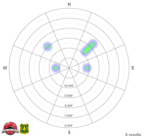
Yesterday, 6 new avalanches were reported in the backcountry. Ski patrols also observed numerous soft slab avalanches failing within the storm snow or at the old snow interface.
  • Powder Park - 9,000' - NW Aspect - 2.5' deep and 50' wide, ran in the early season facets and the ground.
  • Tri-Chutes - 10,700' - West Aspect - 18' deep, ran to the meadow in the early season facets below the new snow. Rider caught and carried.
  • Red Pine Ridge - 9000' - NE Aspect - 20" deep and 50' wide, ran on the new snow old snow interface.
  • Thaynes - 9000' - North Aspect - 2' deep and 50' wide, remotely triggered and failing on the new snow old snow interface.
  • Murdock Peak - 9300' - NE Aspect - 16" and 60' wide.
  • Mid Ivory - 10,200' - East Aspect - 20" and 100' wide.
Photo of the Powder Park avalanche. (PC: J. Shade)

The avalanche heat map shows the location and pattern in the recent avalanches. Most of these avalanches have occurred on west through north through east-facing aspects, the same aspects and elevations the weak faceted snow exists.

As always, you can find all observations and recent avalanches HERE.
Ad
Avalanche Problem #1
Persistent Weak Layer
Type
Location
Likelihood
Size
Description
The avalanches in Powder Park and the Tri-chutes that broke into the old weak snow near or at ground prove that the significant snowfall over the past few days has overloaded our pre-existing weak faceted snowpack. You can expect avalanches to be 2-4' deep, and if caught, probably unsurvivable. If you choose to ride on slopes steeper than 30° where this weak snow exists, you will likely trigger an avalanche.

Dangerous avalanche conditions exist, patience and avoidance will be the name of the game today. Continue to stick to low angle terrain with nothing steep above or connected to it.
Avalanche Problem #2
New Snow
Type
Location
Likelihood
Size
Description
The new snow fell on a variety of weak snow surfaces. Before the recent snow, observes had noted surface hoar and near-surface facets on the snow surfaces throughout the range. Since the snowfall, observes are still able to find these really weak interfaces. Regardless of what you want to call the old snow surface, we know it's weak, and the newest storm snow is our slab. Though this slab is not very uniform, or cohesive, new snow avalanches may still be triggered on all aspects and elevations. If triggered these avalanches may be up to 1-2' deep today. These avalanches may be particularly sensitive on steep west to north to east-facing slopes at all elevation bands and may be triggered remotely or from a distance.
Any new snow avalanche triggered can step down into deeper weaker layers creating a much larger avalanche 2-4' deep.
General Announcements
Please visit this website with information about Responsible Winter Recreation by the Utah Office of Outdoor Recreation.

This information does not apply to developed ski areas or highways where avalanche control is normally done. This forecast is from the U.S.D.A. Forest Service, which is solely responsible for its content. This forecast describes general avalanche conditions and local variations always occur.