Forecast for the Salt Lake Area Mountains

Drew Hardesty
Issued by Drew Hardesty for
Wednesday, January 27, 2021
The avalanche danger will be on the rise today and we may be at HIGH danger later tonight into tomorrow. Dangerous avalanche conditions will become more widespread in the backcountry.
A CONSIDERABLE DANGER exists on many freshly wind loaded slopes in the mid and upper elevations. Natural avalanches are possible; human triggered avalanches are increasingly likely.
Some of these avalanches may be triggered at a distance...and some of these may step down into older weak layers, leading to a larger and more destructive avalanche.
Low angle slopes are the ticket for the next several days.

If you're leaving a resort boundary through an exit point, you are stepping into CONSIDERABLE avalanche danger.
Low
Moderate
Considerable
High
Extreme
Learn how to read the forecast here
Special Announcements
SPECIAL NOTE: HALF OF ALL SKIER/SNOWBOARDER FATALITIES SINCE 99/00 HAVE OCCURRED WITH PEOPLE GOING OUT OF BOUNDS AT A SKI AREA.
Do you have the essential avalanche rescue gear (transceiver, probe, and shovel) and do you know how to use them? Watch this video to see how the three pieces of equipment work together.
Weather and Snow
It's starting to get interesting.
In the big picture, a strengthening storm off the California coast along with what the NWS is calling a "very significant and unusual atmospheric river event" will pummel the Golden State with unbelievable amounts of precipitation. We'll see wind, warming temperatures, and an upside down trend in snow densities over the next 48 hours.
Currently in the Wasatch, skies are mostly cloudy to overcast with some areas already reporting light snowfall. Mountain temperatures are in the single digits.
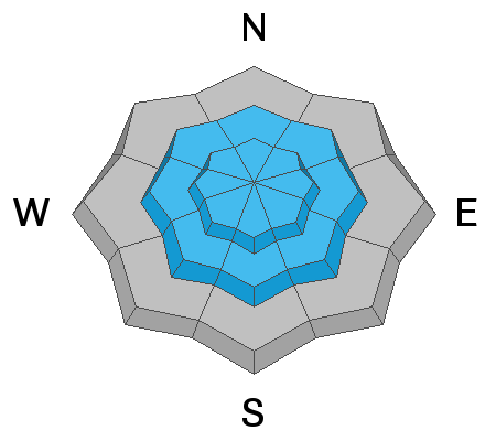
The WINDS ARE THE KEY PLAYER FOR TODAY, however. The southeast to southwest winds have especially picked up in the early hours this morning and are blowing 30-40mph with gusts to 50. The highest elevations have hourly wind speeds of 60mph with gusts to 75. Wind chill there is -27°F.

For today, we'll see light snowfall and moderate to strong southwest winds. The winds may take a breather this afternoon but will only return and redouble their efforts overnight. Higher density snow and strong winds are expected for tomorrow. We may see 6-10" by tomorrow evening. Perhaps more in areas favored by a southwest flow.
Recent Avalanches
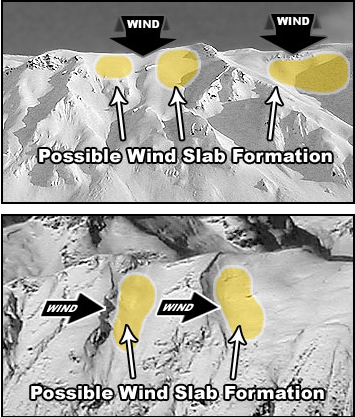
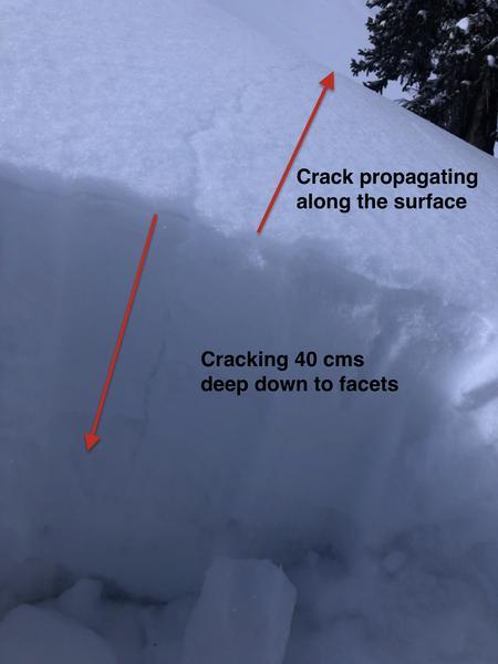
Ski area avalanche teams triggered a few shallow wind drifts from the bump in southeast winds yesterday, but we didn't hear of any avalanches from the backcountry.
New reports from Monday - Both avalanches triggered by people leaving a ski area.
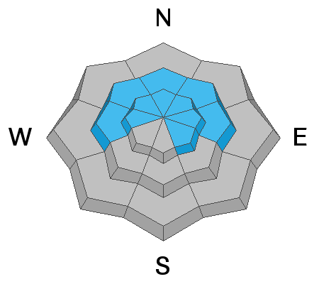
A skier on Rocky Point in the Alta/Brighton backcountry triggered a soft slab avalanche that looked to be perhaps 2' deep and 35' wide. He managed to outrun the slide and was not caught. It does sound like a possible close call from Monday in the Hidden Canyon area (backcountry) adjacent to Brighton. This human triggered slide pulled out 1.5-3' deep and 150' wide on a very steep north facing path at 10,000'.
Special Public Announcement: IF you trigger an avalanche near one of the resorts, please call it in to the ski patrol so they don't have to put themselves in harms way to conduct a meaningless rescue.

As always, you can find all observations and recent avalanches HERE.
Ad
Avalanche Problem #1
Wind Drifted Snow
Type
Location
Likelihood
Size
Description
New and developing wind drifts will likely run naturally today and be sensitive to human provocation on many steep slopes at the mid and upper elevations. Over the past 18 hours, the winds have transported snow from east-southeast as well as southwest. Soft drifts will be found around the compass but more predominantly on west to north to east facing aspects. These drifts will be landing on very low density stellar dendrite snowflakes, well known to be very efficient if not tricky weak layers. Some drifts may triggered at a distance. Remember that shooting cracks are sure signs of unstable wind drifts.
*Note that due to the gusty nature of these winds, drifts may be found well off the ridgelines and eddied in unusual terrain features.
*Note also that we did not see a lot of wind with last Friday/Saturday's storm and there is a lot of snow available for transport.
TREND: INCREASING DANGER
Avalanche Problem #2
Persistent Weak Layer
Type
Location
Likelihood
Size
Description
Our weak layers are proliferating and our complex snowpack is becoming more complex. Today and tomorrow's snow and wind will only add additional stress to one if not both buried persistent weak layers.
The two most problematic weak layers are described below -
- A layer of faceted snow and various patches of surface hoar buried last Friday, now 12-18" deep. Natural and human triggered avalanches in this layering have occurred in the past several days.
- The old dragons in the basement - facets and depth hoar from the early low tide conditions at and near the base of the snowpack, now buried 2-4' deep. Human triggered avalanches in this layering have occurred in the past several days.

Yesterday in Days Fork of BCC, UAC forecaster Greg Gagne experienced a loud audible collapse and triggered a "crack" down to this upper layer of weak snow in Main Days. Pic below.
TREND: INCREASING DANGER
Additional Information
Find the podcast HERE....or find the Utah Avalanche Center podcast wherever you get your favorite podcasts.
General Announcements
Please visit this website with information about Responsible Winter Recreation by the Utah Office of Outdoor Recreation.

This information does not apply to developed ski areas or highways where avalanche control is normally done. This forecast is from the U.S.D.A. Forest Service, which is solely responsible for its content. This forecast describes general avalanche conditions and local variations always occur.