Forecast for the Salt Lake Area Mountains

Drew Hardesty
Issued by Drew Hardesty for
Thursday, January 28, 2021
IT IS DANGEROUS IN THE BACKCOUNTRY.
A CONSIDERABLE DANGER exists on many freshly wind loaded slopes. Natural avalanches are possible; human triggered avalanches are likely.
Some of these avalanches may be triggered at a distance...and some of these may step down into older weak layers, leading to a larger and more destructive avalanche.
Low angle slopes are the ticket for the next several days.

If you're leaving a resort boundary through an exit point, you are stepping into CONSIDERABLE avalanche danger.
Low
Moderate
Considerable
High
Extreme
Learn how to read the forecast here
Special Avalanche Bulletin
SPECIAL AVALANCHE BULLETIN
ISSUED
What
THE AVALANCHE DANGER IS CONSIDERABLE TO HIGH IN MANY AREAS.
When
IN EFFECT FROM 6 AM MST THIS MORNING TO 6 AM MST FRIDAY
Where
FOR THE MOUNTAINS OF NORTHERN UTAH INCLUDING THE WASATCH RANGE...BEAR RIVER RANGE...UINTA MOUNTAINS...
Impacts
DANGEROUS AVALANCHE CONDITIONS EXIST. NATURAL AND HUMAN TRIGGERED AVALANCHES ARE EXPECTED. AVOID BEING ON OR BENEATH STEEP TERRAIN.
Special Announcements
SPECIAL NOTE: HALF OF ALL SKIER/SNOWBOARDER FATALITIES SINCE 99/00 HAVE OCCURRED WITH PEOPLE GOING OUT OF BOUNDS AT A SKI AREA.
Do you have the essential avalanche rescue gear (transceiver, probe, and shovel) and do you know how to use them? Watch this video to see how the three pieces of equipment work together.
Weather and Snow
Snowfall continues in the mountains.
With a 3-5" overnight, storm totals are 6-10" in the upper Cottonwoods and Park City ridgeline. Snow water equivalents are 0.4-0.8".
Snow conditions are thick and cakey where they haven't been either etched, eroded, or deposited into thick wind slabs.
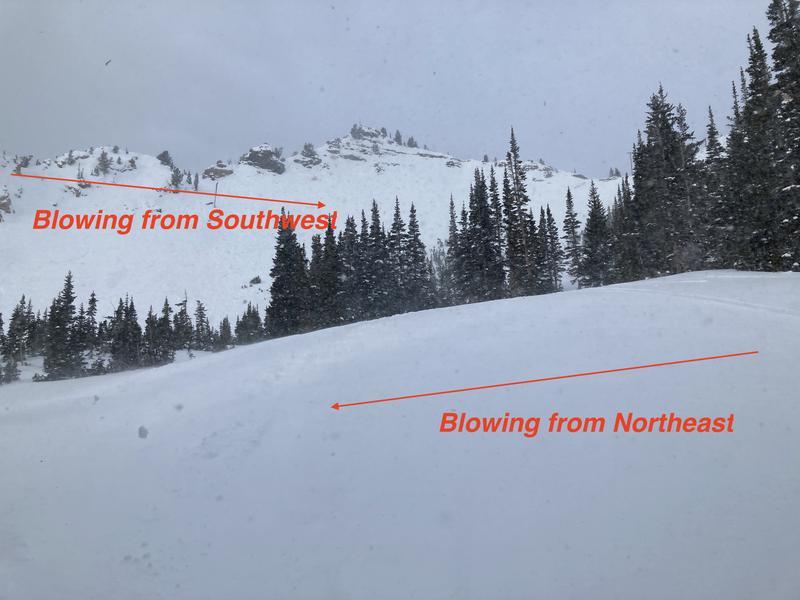
Temperatures, as foretold, have risen during the storm and winds are shrieking even at the mid-elevations from the south and southwest. Hourly averages are 35mph with gusts to 50.
We'll see continued light snowfall today with continued strong southwest winds. Temps will be in the upper 20s.
The next storm arrives later Friday into Saturday.
Mark and Trent found a few gusts up near Bountiful Peak yesterday.
Recent Avalanches
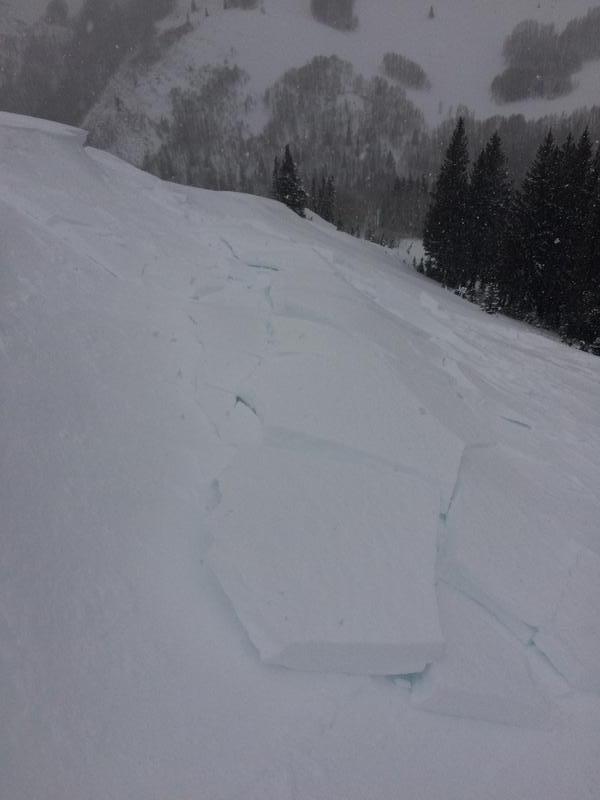
Many backcountry observers noted wind slab activity yesterday on many aspects, even well off the ridgelines. These soft and hard drifts were up to 2' deep...and some were triggered at a distance. Shooting cracks with great propagation were the rule.
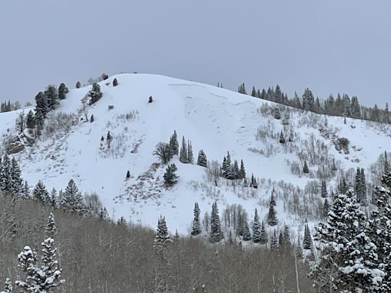
While visibility was limited yesterday, I do have three notable avalanches to report:
  • South Monitor Bowl naturalled to the ground estimated 3-6' deep and 350' wide. East northeast at 9800'.
  • Sound of Music remotely triggered 2-3' deep and 250' wide. Easterly facing at 9200'. (pic below)
  • Bountiful Peak area natural 2' deep and 150' wide. Northeast facing at 8200'.
(locations can be found here - https://wbsguide.com/index.php)
Special Public Announcement: IF you trigger an avalanche near one of the resorts, please call it in to the ski patrol so they don't have to put themselves in harms way to conduct a meaningless rescue.

As always, you can find all observations and recent avalanches HERE.
Ad
Avalanche Problem #1
Wind Drifted Snow
Type
Location
Likelihood
Size
Description
A sea of wind slabs across the landscape. Some will be sensitive, some will be stubborn. Some have and will continue to run naturally. Drifts may be 2-4' thick and well off the ridgelines. Due to the various southerly directions and speeds, along with terrain channeling and eddying, drifts will be on all aspects and elevations.
Guide/educator Chris Brown's pic of sensitive wind slabs yesterday near Powder Park of Mill D North, BCC.
Avalanche pro Sean Zimmerman Wall's observation and photo below well describe the nature of the blowing snow.
Adding insult to injury is the upside down nature of the storm snow as it is coming in heavy and sitting on lower density snow from the previous days.
Your mindset and approach should be to avoid all steep wind drifted terrain today.
Avalanche Problem #2
Persistent Weak Layer
Type
Location
Likelihood
Size
Description
Our buried weak layers are only being stressed further by the wind transported snow.
The two most problematic weak layers are described below -
- A layer of faceted snow and various patches of surface hoar buried last Friday, now 12-18" deep. Natural and human triggered avalanches in this layering have occurred in the past several days.
- The old dragons in the basement - facets and depth hoar from the early low tide conditions at and near the base of the snowpack, now buried 2-4' deep. Human triggered avalanches in this layering have occurred in the past several days.

These layers have shown their cards with South Monitor and Sound of Music as evidence. These are not outliers. We'll see similar ones today.
Additional Information
Find the podcast HERE....or find the Utah Avalanche Center podcast wherever you get your favorite podcasts.
General Announcements
Please visit this website with information about Responsible Winter Recreation by the Utah Office of Outdoor Recreation.

This information does not apply to developed ski areas or highways where avalanche control is normally done. This forecast is from the U.S.D.A. Forest Service, which is solely responsible for its content. This forecast describes general avalanche conditions and local variations always occur.