Forecast for the Salt Lake Area Mountains

Drew Hardesty
Issued by Drew Hardesty for
Friday, January 18, 2019
THE AVALANCHE DANGER IS HIGH. Natural and human triggered avalanches are expected on many aspects and elevations, particularly in areas that have seen the most snow and wind. Those without excellent avalanche and route finding skills should avoid the backcountry through the Monday/MLK weekend.

While the backcountry will be dangerous over the next several days, enjoy the Greatest Snow on Earth at some of the Greatest Ski Resorts on Earth where they employ teams to help mitigate the risk. REMEMBER that if you're going out of bounds, you're entering into High avalanche danger.
Low
Moderate
Considerable
High
Extreme
Learn how to read the forecast here
Avalanche Warning
AN AVALANCHE WARNING CONTINUES FOR THE MOUNTAINS OF NORTHERN UTAH, TO INCLUDE THE BEAR RIVER RANGE, THE WESTERN UINTAS, AND THE ENTIRETY OF THE WASATCH RANGE. STRONG WINDS AND HEAVY SNOWFALL HAVE PUSHED THE AVALANCHE DANGER TO HIGH. NATURAL AND HUMAN TRIGGERED AVALANCHES ARE LIKELY. AVOID BEING ON OR BENEATH STEEP MOUNTAIN TERRAIN. AN ELEVATED AVALANCHE DANGER WILL PERSIST THROUGH THE MLK HOLIDAY WEEKEND.
Special Announcements
BACKCOUNTRY CLOSURES IN EFFECT THIS MORNING on the north side of the road in Little Cottonwood Canyon. INFO
Listen to the first full length episode of the UAC Podcast. Breaking the Stigma with Traumatic Stress - Another Conversation with Dave Richards. Download it on iTunes, Stitcher or from the UAC Blog.
It's worth reading the avalanche accident report from near Silverton Colorado from Jan 5, 2018. Many interesting take home points. INFO

Check out the improved weather links, road conditions, and weather links for each forecast region on the new UAC IOS App. Do you use the NOAA point forecast? If so, now you can bookmark your favorite weather locations in "My Weather" in the App. INFO
Weather and Snow
Just like the old days. Rough storm totals are below. (Overnight/24 hour/storm totals for snow/snow-water-equivalent) It's still snowing, albeit lightly. Temps are in the teens up high, the low 20s down low. Winds are from the west northwest blowing 20-25mph with gusts to 40. Total snow stakes are 85" in the Cottonwoods, and near 50" along the PC ridge. Snow travel was arduous yesterday as the new heavy dense snow came in on top of Wednesday's lower density powder.
LCC: 15"/1.05"...21"/2.01"...33"/2.98"
BCC: 13"/1.1"...24"/2.45"...40"/3.69"
PC: 11"/1.2"...14"/1.6"...21"/2.0"

Greg's Most Excellent Week in Review is hot off the presses.
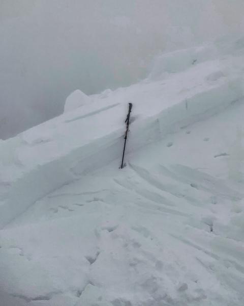
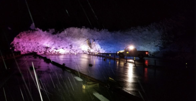
 INFO
Recent Avalanches
The Wasatch Range experienced at least two natural avalanche cycles yesterday with avalanche control teams having excellent results in the field. In the backcountry, at least one large avalanche roared down the east face of Kessler Peak (Chutes and Ladders) and crossed the summer road in two places, leaving a debris field 5-10' deep and 300' wide. One skier was briefly caught and carried in the Canyons backcountry (Python Chutes) in a 10" and 60' wide avalanche but ended up ok. Mark White remotely triggered one if not both of West Monitor and Scotts Bluff into old snow up to 2' deep and almost 100' wide. These are steep northeast facing slopes at 9900' and are repeat offenders from previous avalanche cycles. Another very experienced backcountry skier had a close call coming down the Emmas above LCC. UDOT Provo Canyon triggered a very large avalanche in Slide Canyon (south end of Timpanogos). Uncertain of locations? Steve Achelis's digital and paper maps are the ticket. INFO. Pics of West Monitor (Mark White) and Provo Canyon (Fox news).
Ad
Avalanche Problem #1
Wind Drifted Snow
Type
Location
Likelihood
Size
Description
24 hours of strong southwest to now moderate northwest winds have sensitive drifts to 3' deep on many aspects at the mid and upper elevations. They're to the lee of ridgelines and cross-loaded into couloirs and gullies and may be triggered at a distance or break above you. Windslabs are often manageable but these are not. Too big, too stiff, too unpredictable.
Avalanche Problem #2
Persistent Weak Layer
Type
Location
Likelihood
Size
Description
Anytime you add 30-40" of snow and strong wind, the rapid loading and stress will often find an imperfection somewhere. The interstorm weaknesses from early season as well as those from pre and post Christmas/New Years remain suspect. Thinner snowpack areas and especially areas that have avalanched before showed their hand yesterday and are likely to do so again today. Any new snow avalanche may step down into this old snow layering, resulting in a much more dangerous outcome. Snapped trees, femurs, you get the idea.
Avalanche Problem #3
New Snow
Type
Location
Likelihood
Size
Description
Snowfall rates yesterday and overnight were eye-opening with at-times "3"/hour" intensity. This, combined with the upside down nature of the density trends (even back to Wednesday's storm), leave us with unstable storm snow that will continue to be reactive to human weight on all aspects at the mid and upper elevations. These too are often viewed as "manageable" but are likely too much snow and too upside down for much margin of safety.
Additional Information
We lost the poet Mary Oliver yesterday. She was one of our greatest treasures.
Doesn't everything die at last, and too soon?
Tell me, what is it you plan to do
with your one wild and precious life?
General Announcements
This information does not apply to developed ski areas or highways where avalanche control is normally done. This forecast is from the U.S.D.A. Forest Service, which is solely responsible for its content. This forecast describes general avalanche conditions and local variations always occur.