Forecast for the Salt Lake Area Mountains

Drew Hardesty
Issued by Drew Hardesty for
Thursday, January 17, 2019
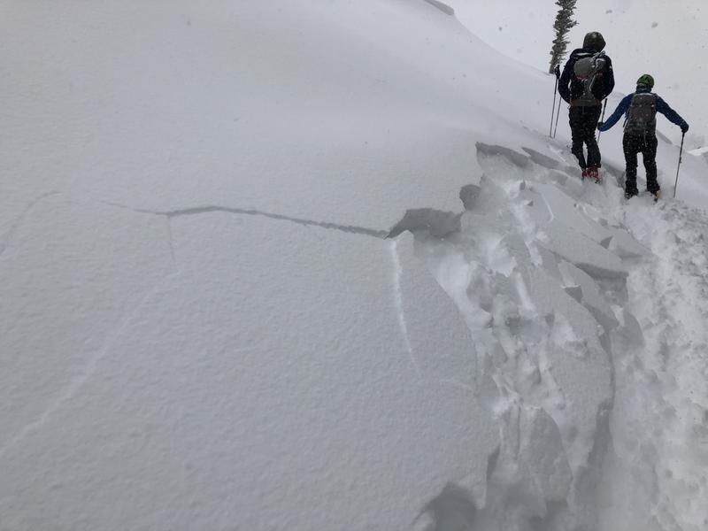
THE DANGER IS ON THE RISE. THE AVALANCHE DANGER STARTS AT CONSIDERABLE THIS MORNING BUT WILL REACH HIGH BY THE AFTERNOON. Natural and human triggered avalanches are expected on many aspects and elevations, particularly in areas that see the most snow and wind. Wet avalanche activity is likely in the low elevations. Those without excellent avalanche and route finding skills should avoid the backcountry through the Monday/MLK weekend.

While the backcountry will be dangerous over the next several days, enjoy the Greatest Snow on Earth at some of the Greatest Ski Resorts on Earth where they employ teams to help mitigate the risk. REMEMBER that if you're going out of bounds, you're entering into Considerable to High avalanche danger.
Low
Moderate
Considerable
High
Extreme
Learn how to read the forecast here
Avalanche Warning
AN AVALANCHE WARNING HAS BEEN ISSUED FOR THE MOUNTAINS OF NORTHERN AND CENTRAL UTAH, TO INCLUDE THE BEAR RIVER RANGE, THE WESTERN UINTAS, THE WASATCH RANGE, AND THE MANTI-SKYLINE PLATEAU. STRONG WINDS AND HEAVY SNOWFALL WILL PUSH THE AVALANCHE DANGER TO HIGH. NATURAL AND HUMAN TRIGGERED AVALANCHES ARE LIKELY. AVOID BEING ON OR BENEATH STEEP MOUNTAIN TERRAIN. AN ELEVATED AVALANCHE DANGER WILL PERSIST THROUGH THE MLK HOLIDAY WEEKEND.
Special Announcements
BACKCOUNTRY CLOSURES IN EFFECT THIS MORNING on the north side of the road in Little Cottonwood Canyon. INFO
Listen to the first full length episode of the UAC Podcast. Breaking the Stigma with Traumatic Stress - Another Conversation with Dave Richards. Download it on iTunes, Stitcher or from the UAC Blog.
Join our own Chad Brackelsberg 6pm tonight at Snowbird for the Utah Adventure Journal series. Free, open to the public. "Skiing your way from the corporate world to leading the non-profit side of the Utah Avalanche Center. INFO

Check out the improved weather links, road conditions, and weather links for each forecast region on the new UAC IOS App. Do you use the NOAA point forecast? If so, now you can bookmark your favorite weather locations in "My Weather" in the App. INFO
Weather and Snow
It appears that yesterday's 6-12" (0.94-1.22" SWE) of new snow yesterday was just the teaser. The next potent storm is on the doorstep and we'll see upwards of another 1-2'+ of new snow through tomorrow midday/afternoon.
Currently, skies are overcast with mountain temperatures in the upper 20s to low 30s. The winds are already the main player, having ramped up overnight from the southwest. They're blowing 35-45mph with gusts to 70. In this warm, pre-frontal environement, the rain-snow line may reach toward 7500' today. The cold front arrives tonight.
Recent Avalanches
Yesterday's storm snow was quite sensitive in the morning to midday hours with many natural and skier triggered avalanches 4-8" deep and 75' wide on all aspects generally above 9000'. Some of these storm snow avalanches were triggered at a distance. The largest avalanche was on Sunset peak at the head of Big Cottonwood Canyon at 10,400' on a north facing aspect at 12" deep and 250' wide. All of these storm instabilities failed at either the new snow/old snow interface or just within the new snow. By the afternoon, most of the morning's instability had settled out. (pc: Gagne)
Ad
Avalanche Problem #1
Wind Drifted Snow
Type
Location
Likelihood
Size
Description
Overnight and newly developing soft and hard wind drifts are expected on many aspects and elevations today and may be triggered at a distance. Avoid steep cross-loaded gullies and note that drifts may be well down off the ridgelines. Natural activity is expected today with the new snow and strong winds. Cracking and collaspsing are immediate signs of instability.
Avalanche Problem #2
Persistent Weak Layer
Type
Location
Likelihood
Size
Description
The snowpack has many new and old generally strengthening weak layers from early season and during the Christmas/New Year's holiday season. Forecasted snow and wind will be a good test for these weaknesses, particularly in thinner snowpack areas of generally less than 3' in depth. Note that any new storm and wind slab avalanches may step down to these old instabilities 2-4' deep, particularly on northwest to east facing slopes.
Avalanche Problem #3
Wet Snow
Type
Location
Likelihood
Size
Description
The warm early start to the storm may allow the rain/snow line to reach 7000-7500' today. Wet avalanches will be possible at these elevations and may run naturally at and after the onset of rain. Gullies and terrain traps may fill with wet loose debris. This hazard may be of particular interest to otherwise "low risk" groups such as trail runners, snow shoers, and people walking their dogs.
Additional Information
General Announcements
This information does not apply to developed ski areas or highways where avalanche control is normally done. This forecast is from the U.S.D.A. Forest Service, which is solely responsible for its content. This forecast describes general avalanche conditions and local variations always occur.