Forecast for the Provo Area Mountains

Nikki Champion
Issued by Nikki Champion for
Thursday, March 30, 2023
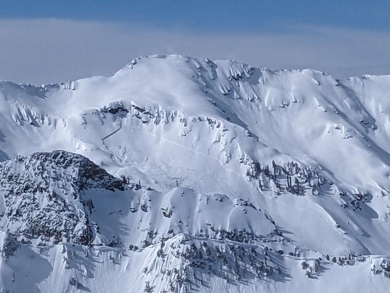
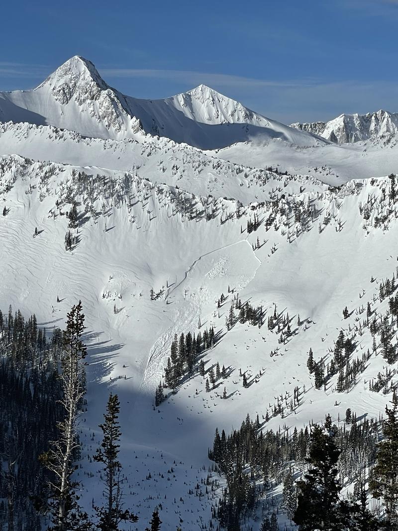
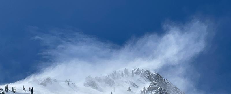
The avalanche danger is CONSIDERABLE on mid and upper-elevation slopes where new snowfall and days of high winds have created dangerous avalanche conditions. The elevated winds will continue to create unstable slabs of wind-drifted snow at all mid and upper elevations. Both loose snow and slab avalanches may be possible within layers of new snow at all elevations.
Both wind-drifted and new snow avalanches will likely fail 1-2’ deep, but have the potential to fail deeper at the new/old snow interface that is now down 2-5’ in places. For that reason, cautious route-finding, and conservative decision-making will be essential today.

Avalanche danger will be on the rise into the evening, and any periods of heavy snowfall throughout the day have the potential to increase the avalanche hazard to HIGH if peak snowfall intensities pan out or the weather moves in earlier than forecast.
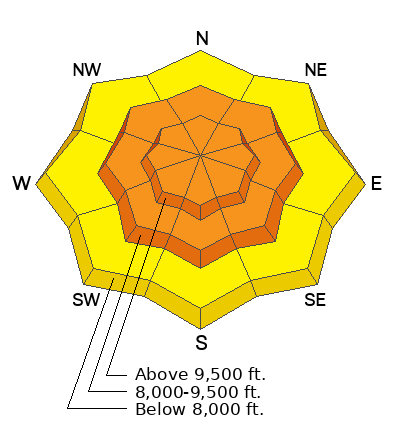
Low
Moderate
Considerable
High
Extreme
Learn how to read the forecast here
Special Announcements
On Monday, March 27, two snowmobilers were riding in the Oquirrh Mountains. One was caught, carried, and fully buried in a very large avalanche. His partner, friends and family, Utah County Search and Rescue, Utah Department of Public Safety, and LifeFlight participated in the rescue, but he sadly did not survive. The preliminary avalanche report can be found HERE.
Our sincerest condolences go out to everyone affected by this tragic avalanche.
We are in the process of finalizing a report about the March 9th avalanche fatality in the Uintas. Thank you for your patience, and we will publish the final report in coming days.
Thank you to everyone who donated to our Spring Campaign. We appreciate your support and look forward to creating new tools to help you stay safe in the backcountry.
Weather and Snow
This morning, the skies are overcast. Mountain temperatures are sitting in the mid-20s F. Winds have decreased a bit since yesterday, and are blowing from the southwest at speeds of 5-15 mph, with gusts up to 30 mph. At the highest ridgelines, winds are gusting into the upper 40s mph. Overnight snowfall totals range from 1.5 - 5".
Today, snow showers will continue primarily late morning through the afternoon ahead of a strong northwest flow this evening. Temperatures will climb into the mid 30s F. Winds will become more westerly and average 5-15 mph, with gusts up to 40 mph. The mountains could get an additional 2-4" of new snow before 5 PM, with the potential for periods of snowfall up to 1"/hr.
This evening, this Northwest flow takes off. Snowfall will become heavy overnight, with peak snowfall rates up to 2"/hr and winds will transition more west-northwesterly with gusts up to 40 mph. The mountains could receive an additional 9-16" overnight. Periods of heavy snow will continue through Friday morning before tapering into showers, and a temporary break before the next potent system makes it's way through the area late Sunday.
Recent Avalanches
Yesterday, was generally quiet in the backcountry but reports of avalanches continue to roll in. Over 23 avalanches have been reported from the Northern, Central and Southern Wasatch backcountry since Monday. These have been primarily soft slabs of both new snow, and wind-drifted snow at the mid and upper elevations. With the good visibility, a few impressive naturals were reported that likely occurred between the 26th and 27th, including notable large avalanche from Mill B and Rainbow Peak.
  • Mill B South - Northeast Aspect - 9500' - 5' deep - 1500' wide (photo 1 below - Chester)
  • Rainbow Peak - East Aspect - 9700' - 4' deep - 500' wide (photo 2 below - Sean R)
Find all recent observations HERE.
Ad
Avalanche Problem #1
Wind Drifted Snow
Type
Location
Likelihood
Size
Description
With soft snow available for transport and elevated winds accompanying this front, you'll likely find new and developing slabs of wind-drifted snow at all mid and upper elevations. The slabs will be most pronounced on lee-ward facing slopes, but elevated can load any aspect as winds swirl and change direction as they pass through the mountains, this is known as cross-loading
As the winds continue to blow, these slabs will become firmer and more cohesive. This can allow you to travel out farther onto the slope before it breaks, and can fail larger and wider than expected.
Look for blowing and drifting snow and avoid any slopes with fresh deposits of wind-drifted snow. Today is not the day to mess with any steep slope, greater than 30°, that the wind has loaded.
Photo of wind-drifting snow at the highest ridgetops above American Fork. D. Kelly

Cornices: We have gotten a few reports of natural cornice fall. Cornices are currently large and only continue to grow in the backcountry. With today's new snow and high winds, we will continue to see more cornices breaking naturally. Give cornices, and the edges of cornices a wide berth as they often break farther back than expected. Limit your exposure to slopes below cornices. A cornice fall could trigger a larger slab of wind-drifted snow below.
Avalanche Problem #2
New Snow
Type
Location
Likelihood
Size
Description
As the snowfall increases, the avalanche danger is going to increase as well. As of sunrise, roughly 5" inches of new snow has fallen throughout the Provo area mountains and the incoming front is predicted to have multiple periods of high snowfall rates this morning and overnight. Out of the wind zone, both slab and loose snow avalanches may break within different the layering of new snow from the last week.
When the snowfall rates are higher, generally greater than 1" per hour, avalanches will be easier to trigger, and more likely to act as a cohesive slab. Pay attention to changing weather and increased snowfall rates.
These avalanches may fail within the new snow (1-2' deep) or at the new snow/old snow interface (which is now 2-5' down) as we saw near the Ant Knolls, Rainbow Peak, and Mill B. It has also been reported that some new snow avalanches have then stepped down to this older interface from last week. These could be large and deadly avalanches, as Drew said earlier this week "the snowpack is more rich, complex, and interesting than I want it to be right now." We have just received so much snow with very few breaks, and the snowpack has not had time to adjust to these large stressors.
Until the snowpack stabilizes, or we get more time between storms, I plan on sticking to lower-angle slopes.
General Announcements
This information does not apply to developed ski areas or highways where avalanche control is normally done. This forecast is from the U.S.D.A. Forest Service, which is solely responsible for its content. This forecast describes general avalanche conditions and local variations always occur.