Forecast for the Provo Area Mountains

Greg Gagne
Issued by Greg Gagne for
Friday, March 31, 2023
The avalanche danger is HIGH at the mid and upper elevations due to heavy snowfall and strong winds. Natural avalanches are likely and human-triggered avalanches are very likely. Avalanches may break down several feet deep and hundreds of feet wide. The avalanche danger is CONSIDERABLE at low elevations.
Travel in avalanche terrain is not recommended.
Avalanches may run down into valley bottoms as avalanche paths are filled in and smooth.
Low
Moderate
Considerable
High
Extreme
Learn how to read the forecast here
Special Announcements
On Monday, March 27, two snowmobilers were riding in the Oquirrh Mountains. One was caught, carried, and fully buried in a very large avalanche. His partner, friends and family, Utah County Search and Rescue, Utah Department of Public Safety, and LifeFlight participated in the rescue, but he sadly did not survive. The preliminary avalanche report can be found HERE.
Our sincerest condolences go out to everyone affected by this tragic avalanche.
We are in the process of finalizing a report about the March 9th avalanche fatality in the Uintas. Thank you for your patience and we will publish the final report in coming days.
Thank you to everyone who donated to our Spring Campaign. We appreciate your support and look forward to creating new tools to help you stay safe in the backcountry.
Weather and Snow
This morning: It is snowing with overnight snow totals of 12". Temperatures are in the lower 20's F and winds are from the west/northwest. At 11,000', winds are gusting over 70 mph while gusting into the mid 30's mph at mid elevations.
Today: The National Weather Service has issued a Winter Storm Warning through 9 pm this evening. Snow - heaviest through the morning hours - with an additional 3-6" possible by the end of the day. The west/northwest winds will slowly decrease through the day, but remain elevated, averaging in the teens with gusts near 30 mph at mid-elevations. At the upper elevations, winds will average in the 30's mph with gusts up to 60 mph.
This Weekend: Sunny and breezy on Saturday with warming temperatures. Another significant winter storm late Sunday into early this coming week.
Recent Avalanches
Resorts are reporting sensitive avalanche conditions this morning with natural avalanches that are propagating widely.
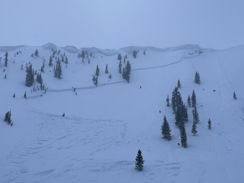
We received few observations from the backcountry on Thursday. The avalanche that should get everyone's attention was a natural avalanche in Two Dogs on a northeast-facing slope at 10,200' in upper Days Fork in the Salt Lake mountains. The avalanche was triggered by a natural cornice fall and broke an estimated 6' deep and several hundred feet wide. (Photo below from Calvin Hawley).
Find all recent observations HERE.
Ad
Avalanche Problem #1
New Snow
Type
Location
Likelihood
Size
Description
Heavy snowfall overnight and into today has created sensitive soft slabs of storm snow. Avalanches may fail within today's storm snow or into one of many deeply-buried interfaces from the 8' of snow we have received over this past week. Thursday's natural avalanche in Two Dogs provides a perfect example of how deep and wide avalanches may fail. Similar avalanches this week have failed down into these deeply-buried layers, including Ant Knolls, Rainbow Peak, and Mill B South.
UAC director Mark Staples discusses this complex layering from his field day in Farmington Canyon on Thursday:
It's just too complex a situation with an unforgiving penalty if you were to be involved in an avalanche failing this large.
Avalanche Problem #2
Wind Drifted Snow
Type
Location
Likelihood
Size
Description
Moderate to strong west/northwest winds have an abundance of soft snow to transport and you will find sensitive slabs of wind-drifted snow at the upper elevations as well as some mid elevation slopes. Triggering an avalanche involving a recent or fresh wind drift may step down into one of the deeply-buried interfaces.

The cornices are immense and recent winds have only added to their size and sensitivity. Cornices may break off naturally, triggering an avalanche onto the slope, as we saw on Thursday in Two Dogs. Travel well-back from corniced ridgelines and do not travel below a slope with cornices above.
General Announcements
This information does not apply to developed ski areas or highways where avalanche control is normally done. This forecast is from the U.S.D.A. Forest Service, which is solely responsible for its content. This forecast describes general avalanche conditions and local variations always occur.