Forecast for the Provo Area Mountains

Dave Kelly
Issued by Dave Kelly for
Saturday, April 1, 2023
The avalanche danger is HIGH due to recent heavy snowfall, wind transported snow, and today's forecasted sun and clear skies. Avalanches may break 2-3' feet deep and 100-200' feet wide.

Give yesterday's storm time to settle out and stick to terrain under 30 degrees. Travel in and below avalanche terrain is not recommended.
Low
Moderate
Considerable
High
Extreme
Learn how to read the forecast here
Avalanche Warning
An avalanche warning is in effect from now until 6am on Sunday April 2, 2023 for the Mountains of Northern Utah.
Recent heavy snowfall and strong winds have created dangerous avalanche conditions in the backcountry. Human triggered and avalanches are likely. Travel in avalanche terrain is not recommended. Stay off of and out from under slopes steeper than 30 degrees.
Weather and Snow
Yesterday, ski areas at the top of the Cottonwood Canyons broke the 800" mark and many ski area and mountain operations reported record breaking March snow totals. This snowfall is similar to what you will find in the northern part of the Provo Area Forecast Region.
This morning under partly cloudy skies, temperatures are in the mid 20's ˚F. Winds are blowing south-southeast in the teen's gusting to the 30's MPH at the lower elevations and south-southwest 30 gusting to 45 MPH at the 8,000' ridgelines. Some mountain locations reported a trace of additional snow overnight.
For today, skies will be clear with clouds building later this afternoon. Temperatures will be spring like, rising to 42-46˚F, and winds will gradually increase from a southwest direction 25 gusting to 50 at the 9,000' ridgelines and 35 gusting to 60 MPH at the 11,000' ridgelines. No precipitation is expected today.

Storm Totals/Snow Water Equivalent since Wednesday and Snow Depths
  • Provo Area Mountains 18-19.5" snow/ 1.25-1.5" water with snow depths from 101-168"
  • Upper Cottonwoods 33-47" snow/1.92-2.73" water with snow depths from 109-229"

The National Weather Service has issued a Winter Storm Watch from Sunday April 2- Tuesday April 4th with another 20 to 30" of snow with locally higher amounts.
Recent Avalanches
Yesterday backcountry riders and mountain operations reported sensitive avalanche conditions. There were delays and closures due to avalanches on highways throughout the Wasatch.

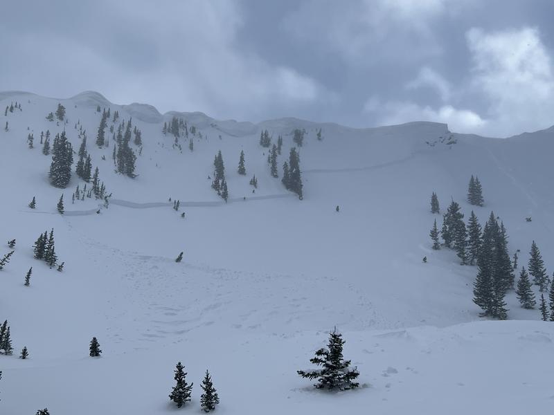
A natural avalanche in West Porter got my attention because of how much exposure there is to overhead avalanche terrain in Porter Fork which is similar to overhead hazard in the Aspen Grove area. There was a report of a large natural in Aspen Grove yesterday morning and a close call in Rock Canyon where a skier was carried downslope in a pocket of wind-drifted snow.

Recent snowpits showed us a handful of weak layers now buried 3-5' deep, and today is not a day I would want to play the "am I good or am I lucky game".
Check out all observations HERE.
Ad
Avalanche Problem #1
New Snow
Type
Location
Likelihood
Size
Description
Heavy snowfall over the last week has created sensitive soft slabs of storm snow. Avalanches may fail within today's storm snow or on one of many deeply-buried interfaces within the storm snow.

Storms have been and continue to be stacked and brief breaks of sun have created a crust/facet sandwich in isolated areas that could cause deep and wide avalanches. The Upper Cottonwoods smashed through the 800" snowfall mark yesterday. This is a lot of snow and this makes for complex layering in the top layers of the snowpack. UAC director Mark Staples discusses snowpack layering HERE.
Photo (J. Gonzalez-Perez) of skier triggered avalanche in Aspen Grove from prior to the storm. These lingering instabilities were present before the last burst of snow. I would give them more time to settle out before traveling in or under steep terrain.
Avalanche Problem #2
Wind Drifted Snow
Type
Location
Likelihood
Size
Description
Moderate to strong south/southwest winds have an abundance of soft snow to transport and you will find sensitive slabs of wind-drifted snow at the upper elevations as well as some mid elevation slopes. Triggering an avalanche involving a recent or fresh wind drift may step down into one of the deeply-buried interfaces.

The cornices are immense and recent winds have only added to their size and sensitivity. Cornices may break off naturally, triggering an avalanche onto the slope below. Travel well-back from corniced ridgelines and do not travel below a slope with cornices above.
On Thursday this avalanche in Two Dogs was triggered by a natural cornice fall and broke an estimated 6' deep and several hundred feet wide. (Photo C. Hawley).
Avalanche Problem #3
Wet Snow
Type
Location
Likelihood
Size
Description
Today's heating will INCREASE the avalanche danger on solar aspects. Steep rocky gully features on the sunny side are of concern. Expect to see wet loose avalanches with an off chance of seeing wet slab avalanches that may run into lower elevation terrain. Snow doesn't like rapid change and today is the first day that this new snow will see direct sun and increased temperatures. This wet snow hazard can be avoided by staying off of sun-heated slopes during the warmest hours of the day. Roller-balls and pinwheels are signs that it is time to find another slope.

Any mountain homes with snow on the roof will be suspect as the sun warms things up. Stay away from roof lines and check to make sure children playing and adults shoveling are clear of roof lines once the sun heats up.
General Announcements
This information does not apply to developed ski areas or highways where avalanche control is normally done. This forecast is from the U.S.D.A. Forest Service, which is solely responsible for its content. This forecast describes general avalanche conditions and local variations always occur.