UDOT PLANNED AVALANCHE CLOSURES!!

Observation: Dry Fork

Observation Date
3/28/2023
Observer Name
Kelly
Region
Provo » American Fork » Dry Fork
Location Name or Route
Dry Fork-American Fork
Weather
Sky
Clear
Wind Direction
West
Wind Speed
Strong
Weather Comments
Clear skies. Cold temperatures ( 0-13 ˚F) to start the day and warmed up to above freezing (39-42 ˚F). Winds were strong from the west and southwest along the ridgetops and from the northeast starting at 9,000' in American Fork. Winds below 9,000' were calm-light. Flagging along the highest ridgelines and snow being transported and loaded onto leeward aspects (north-northeast-east)
Snow Characteristics
New Snow Depth
8"
New Snow Density
Medium
Snow Surface Conditions
Powder
Damp
Snow Characteristics Comments
North-east facing slopes above 9,500' had dry powder. Lower than than 9,500' on the solars was a damp snow surface with signs of rollerballing on south-west facing aspects as the day went on.
Tree bombs started to drop around 1215 and today felt like the first spring weather day.
Red Flags
Red Flags
Wind Loading
Rapid Warming
Avalanche Problem #1
Problem
Wind Drifted Snow
Trend
Increasing Danger
Problem #1 Comments
Photo of wind-drifting snow at the highest ridgetops above American Fork. As winds continue to pick up there is a lot of snow available for transport.
Avalanche Problem #2
Problem
Wet Snow
Trend
Decreasing Danger
Problem #2 Comments
Sun on new snow will create roller-balls and wet loose avalanches. These can be timed to release when the sun is on steep slopes and avoidance can be used during times of increased hazard. This trend will ebb and flow as we get snow/sun patterns. I noted more wet loose activity on steeper due south slopes that had rock visible.
Photo of small roller balls on a south-east facing aspect at 8,900'.
Snow Profile
Aspect
East
Elevation
10,000'
Slope Angle
28°
Comments
Extended column tests without propagation results in the top 2' of the snowpack. These will settle out over time.
Overall ECTX with failure on faceted graupel layer above a pencil hard rounded grains with propagation x2 after ECTX with a hard shovel pry.
I would be surprised if this layer was the culprit in further avalanches. The snowpack in this location was over 430cm as I could not hit the bottom with a 300cm probe in the floor of the snowpit.
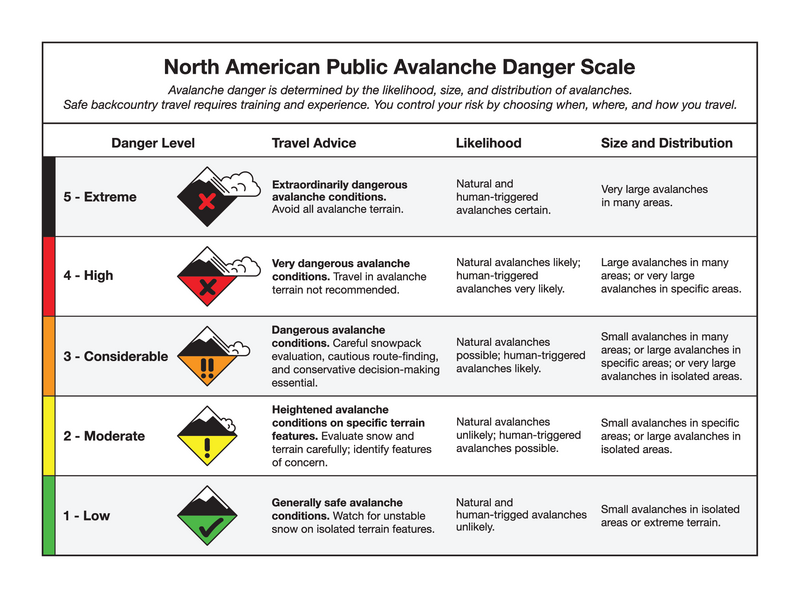
Today the snowpack felt like Moderate danger as in natural avalanches were not likely and human triggered avalanches were possible. I chose to travel like it was a Considerable day and used cautious route finding as I traveled.
Although Moderate puts it at Level 2 on the scale I don't think that every day is as black/white as the scale strives for. I think there are varying degrees of Moderate and today was a higher danger Moderate than other days have been. There are too many unknowns within the storm instabilities and I was looking for areas like this and this and the risk of finding those locations led me to stick to travel on slopes at and below 30 degrees.
Today was also the first real day of sun in quite some time and I was giving the snowpack another day to settle out.
Video of faceted graupel 115cm from the surface.
Video
Today's Observed Danger Rating
Moderate
Tomorrows Estimated Danger Rating
None
Coordinates