Forecast for the Provo Area Mountains

Brooke Maushund
Issued by Brooke Maushund on
Saturday morning, March 28, 2026

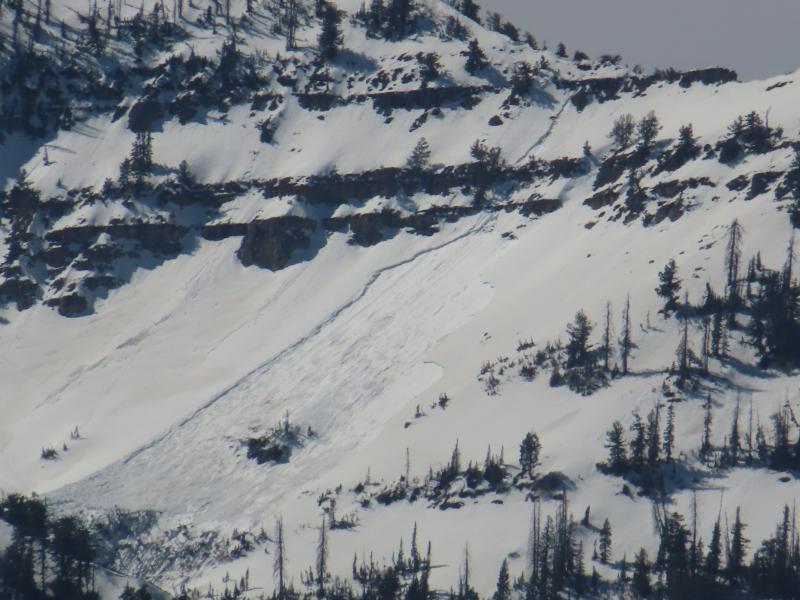
The avalanche danger is MODERATE. Without a refreeze last night, danger will increase throughout the day as rising temperatures make wet snow avalanches more likely. Start early, end early, and stay off and out from under steep slopes with unsupportable snow as the day goes on.

Wet snow avalanches increase our uncertainty—increase your travel margins accordingly.

(Gray on the danger rose indicates little to no snow.
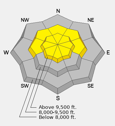
Low
Moderate
Considerable
High
Extreme
Learn how to read the forecast here
Special Announcements

A new version the UAC's mobile app has been released with new features and improvements. Learn more and download the app HERE.

Weather and Snow

Yesterday, riders enjoyed improved sliding conditions with the first refreeze in 10 days the night prior. However, temperatures climbed into the 60s F during the day (a balmy 62°F at Aspen Grove) under clear skies. Last night, lows were mostly in the 40s F. Yikes.

This morning, the snowpack remains mostly wet and unconsolidated, with temps in the mid 40 to 50s F. Light variable winds may have helped cool surfaces and will continue, but won't do much for the snowpack as a whole. High clouds move in today, but high-pressure remains with temps set to climb into the 60s F.

Looking ahead, calm weather continues through the weekend. There are two small systems slated to arrive next week, but they'll remain duds until proven otherwise for me—as they've been trending drier and drier in model runs.

Recent Avalanches

There were no recent avalanches reported yesterday from the Southern Wasatch. Access is becoming increasingly challenging as low and mid-elevation snow melts. I was able to spy some slides from the past week along the Provo skyline yesterday:

Over the last week, many wet snow avalanches have occurred and have been documented from Mill Canyon Peak, Box Elder Peak and along the Cascade Ridge. Big thanks to UDOT Provo for getting out and recording the avalanche activity.

Avalanche Problem #1
Wet Snow
Type
Location
Likelihood
Size
Description

In the last 11 days, the snowpack has only seen one refreeze, two nights ago. After temperatures warmed past 60°F yesterday, overnight lows only reached the 40s F. The snowpack remains mostly wet and unconsolidated.

  • Wet Loose: This will be the most common concern, with the possibility for natural and human-triggered avalanches involving wet snow near the surface. These may be long-running and gouge down into the snowpack. These avalanches are especially dangerous in steep terrain or above terrain traps such as steep-sided gullies, where escaping the flow is difficult.
  • Cornices: As temperatures rise, large cornices built earlier in the season become more and more fragile. Steer clear of traveling directly under these or through runouts where a falling cornice may trigger a larger wet slide once it impacts the slope above. Be sure to give them a wide berth when traveling on ridgelines, as they can break back further than expected.
  • Wet Slabs & Glide Avalanches: As meltwater moves deeper into the snowpack, it can pool on buried crusts or weak layers, weakening the structure and allowing avalanches to break deeper and wider. These are larger and more destructive slides and may occur naturally. Glide avalanches happen when this water pools at the ground, causing the whole snowpack to slide—typically over smooth rock slabs or grassy slopes. Avoid traveling on or beneath slopes with visible glide cracks.

Photo taken by UDOT avalanche forecasters showing recent wet slab activity in the Provo mountains.

Additional Information

A note about wind, crusts, and refreezes: You may find very thin surface refreezes/crusts caused by light winds cooling surfaces overnight, but don’t mistake that crunch under your feet for a refreeze of the snowpack. Think about overheating on a hot summer day on a blistering hike, under the strong sun, with no breeze. Then, a small, light rush of wind cools off your brow, but is over before you realize what’s happened. Your body remains at an absurd temperature as you carry on in your sweltering hike. That’s what this wind is doing for the snowpack: it might cool surfaces for a moment, but it’s not doing much to refreeze down the snowpack as a whole.

General Announcements

This information does not apply to developed ski areas or highways where avalanche control is normally done. This forecast is from the U.S.D.A. Forest Service, which is solely responsible for its content. This forecast describes general avalanche conditions and local variations always occur.