Forecast for the Provo Area Mountains

Greg Gagne
Issued by Greg Gagne for
Monday, March 18, 2019
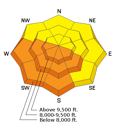
The avalanche danger is MODERATE early this morning, but will increase to CONSIDERABLE for Wet Snow avalanches on sunlit slopes.

On mid and upper elevation slopes facing northwest through southeast, there is still a chance of triggering a deeper, wider avalanche failing on old, faceted snow layers, and the avalanche danger is a solid MODERATE. Careful route finding and snowpack evaluation is necessary for travel in this terrain.
Low
Moderate
Considerable
High
Extreme
Learn how to read the forecast here
Special Announcements
The latest podcast is out! The Wise Ones - A Conversation About Mentorship with Eeva Latosuo and Aleph Johnston-Bloom. LINK
Weather and Snow
Temperatures this morning in the Provo mountains are in the upper 20's and low 30's F and winds are westerly and light, less than 10 mph, with high thin clouds overhead.
For mountain weather, expect high thin clouds and temperatures rising into the low 40’s at lower elevations and 30’s F at mid elevations. Temperatures will rise to just about freezing at 11,000’. Winds will be westerly and light, averaging less than 10 mph with a few gusts in the teens.
For those sharing my boredom with the current weather, there is a glimmer of hope for a somewhat more active weather pattern beginning later this week. Although no significant storms are in sight, there are chances for moisture, and although the track currently seems to favor southern and central Utah, enough moisture may make its way north.
Recent Avalanches
After a significant wet avalanche cycle on Saturday in the Provo mountains (link), additional large, wet activity was reported from the Provo mountains again on Sunday. This includes a large slide that ran nearly 3000' vertical, burying Squaw Peak road under 15' of debris. [Photo UDOT Provo] More details from Sunday's wet activity can be found by clicking here.
If you're getting out in the Provo mountains please send us an observation. It helps us be more accurate with forecasting. You can easily fill one out by clicking HERE.
Ad
Avalanche Problem #1
Wet Snow
Type
Location
Likelihood
Size
Description
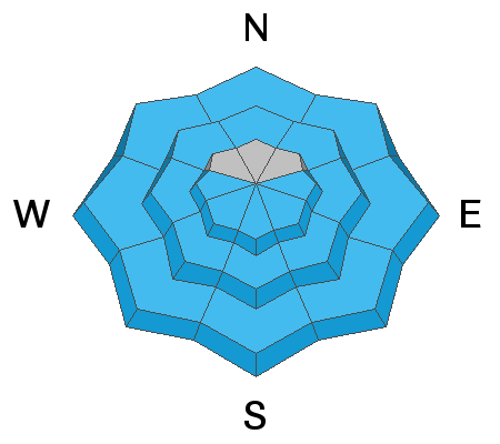
The snow surface has had another night with a solid refreeze, but wet avalanches are likely as the snow heats up from the sun. This hazard should be taken seriously! Not only are wet, loose sluffs likely, but natural wet slab avalanches are as well, and they may run a few thousand feet to valley bottoms. Plan your exits so you're not coming out of steep canyon bottoms during the heat of the day.
Avalanche Problem #2
Persistent Weak Layer
Type
Location
Likelihood
Size
Description
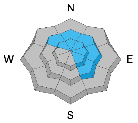
The Provo snowpack remains dangerous on some mid and upper elevation aspects, with a complexity that makes it difficult to identify patterns. Field reports indicate persistent weak layers are still reactive to stability tests, and this is enough for very experienced people to continue to provide a wide buffer of margin in this terrain. These are difficult and dangerous conditions to assess because to get into the upper elevation bowls, one must walk in/underneath many large slide paths. With warming from the sun, avalanching down in these persistent weak layers can produce very large avalanches, breaking several feet deep and hundreds of feet wide, possibly larger.
Additional Information
Thinking about a trip south to the La Sals? It is a much different avalanche situation to our south with significantly more dangerous avalanche conditions. Be sure to check the forecasts for the La Sals (link) as you plan your trip.
General Announcements
This information does not apply to developed ski areas or highways where avalanche control is normally done. This forecast is from the U.S.D.A. Forest Service, which is solely responsible for its content. This forecast describes general avalanche conditions and local variations always occur.