Fall Auction is now live! Check it out now

Forecast for the Provo Area Mountains

Greg Gagne
Issued by Greg Gagne on
Sunday morning, December 25, 2022
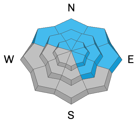
The avalanche danger is MODERATE on all slopes facing northwest through north and east and mid and upper elevation slopes facing southeast. Human-triggered avalanches are possible and avalanches may break down 1-4' deep.
The avalanche danger is LOW on all other slopes, although isolated pockets of reactive wind-drifted snow may be found on all aspects at the upper elevations.
Low
Moderate
Considerable
High
Extreme
Learn how to read the forecast here
Weather and Snow
A trace to around an inch of dense snow fell yesterday, with a thin rime crust on many slopes.
Temperatures this morning are in the 20's F. Winds are from the northwest and have increased slightly overnight. Along exposed, mid-elevation ridges, wind speeds are averaging in the low teens with gusts in the 20's mph, while averaging in the 20's mph with gusts around 40 mph at the upper-most elevations. Skies are overcast with a layer of low-level clouds.
For today, mostly-cloudy skies with temperatures rising into the low 30's F. The northwest winds will average in the teens with gusts in the 20's at the mid elevations and average in the 20's with gusts around 40 mph at the highest elevations. We may get an inch or so of damp snow with possible riming.
Monday will bring warmer temperatures ]ahead of a potentially potent atmospheric river event beginning Tuesday. Weather looks to remain active through the end of the year.
(Photo below from Dave Kelly on Timpanogos)
Recent Avalanches
No avalanche activity was reported from Saturday.
Ad
Avalanche Problem #1
Persistent Weak Layer
Type
Location
Likelihood
Size
Description
Our persistent weak layer (PWL) of faceted snow that formed during the mid-November drought is buried underneath 2-4' of snowfall and wind-drifted snow and avalanches failing on this buried PWL were last reported over a week ago. On my field day yesterday, my partner and I were focusing at the mid-elevations and were finding the PWL continues to slowly gain strength (video discussion below). Dave Kelly was on Timpanogos yesterday and was finding similar results.
Although we are moving in the right direction, spatial variability exists and human-triggered avalanches are possible, especially on slopes that were wind-loaded during the strong wind event from this past Wednesday and Thursday.
General Announcements
As the end of the year approaches, please consider a donation to the UAC to support avalanche forecasting.

This information does not apply to developed ski areas or highways where avalanche control is normally done. This forecast is from the U.S.D.A. Forest Service, which is solely responsible for its content. This forecast describes general avalanche conditions and local variations always occur.