Fall Auction is now live! Check it out now

Forecast for the Provo Area Mountains

Trent Meisenheimer
Issued by Trent Meisenheimer on
Saturday morning, December 24, 2022
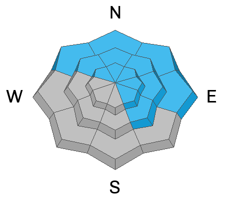
The avalanche danger is MODERATE on all mid and upper-elevation steep slopes for wind-drifted snow. These avalanches could be 1-2 feet deep and up to 100 feet wide. Human-triggered avalanches are possible.
Give extra caution to northerly (shady) facing terrain because of a buried persistent weak layer of faceted snow 1-4 feet deep. An avalanche here would likely be a season-ender or worse.
Low
Moderate
Considerable
High
Extreme
Learn how to read the forecast here
Special Announcements
Announcement: As the end of the year approaches, please consider a donation to the UAC to support avalanche forecasting.
Weather and Snow
This morning, light snow is falling in some areas with mountain temperatures in the low 20s °F. Winds are from the northwest blowing 5-15 mph across upper elevation 10,000' ridges and peaks. Higher up, the northwest wind blows 20-30 mph.
Today, we will see cloudy skies with light snowfall and or rime for the morning hours. Accumulations will be lean, with a trace to maybe a couple of inches of new snow in favored locations. Temperatures will rise into the upper 20s °F this afternoon. Winds will remain from the northwest at speeds of 5-15 mph.
Recent Avalanches
No new avalanches were reported from the backcountry. Be sure to check out all the observations HERE.
Ad
Avalanche Problem #1
Wind Drifted Snow
Type
Location
Likelihood
Size
Description
Over the past few days, strong winds have wreaked havoc throughout the mountains. Winds swirled and drifted snow on many terrain features like mid-slope break overs and cross-loaded ridges or gullies. Be on the lookout and avoid slopes where the wind has loaded and where it's possible to trigger a shallow soft or hard wind slab.

Any wind slab avalanche that you trigger has the potential to step down into deeper weak layers within the snowpack, creating a more dangerous avalanche.
Trend: Decreasing danger
Avalanche Problem #2
Persistent Weak Layer
Type
Location
Likelihood
Size
Description
Weak, sugary faceted snow (persistent weak layer) is now buried 1-4 feet deep on almost all aspects and elevations throughout the Wasatch Range. Avalanches failing on a persistent weak layer will likely be 1-4 feet deep and a few hundred feet wide. The most suspect slopes will be northerly facing terrain where it's been recently loaded by the wind.
It's been several days since we've seen an avalanche triggered on this persistent weak layer. However, even the slightest possibility of such an avalanche should lead you to tone down your terrain selection. I will continue to avoid steep north-facing terrain for the time being.
General Announcements
As the end of the year approaches, please consider a donation to the UAC to support avalanche forecasting.

This information does not apply to developed ski areas or highways where avalanche control is normally done. This forecast is from the U.S.D.A. Forest Service, which is solely responsible for its content. This forecast describes general avalanche conditions and local variations always occur.