Forecast for the Provo Area Mountains

Drew Hardesty
Issued by Drew Hardesty for
Saturday, December 2, 2023
Dangerous avalanche conditions exist and they will only become more dangerous overnight and into tomorrow.
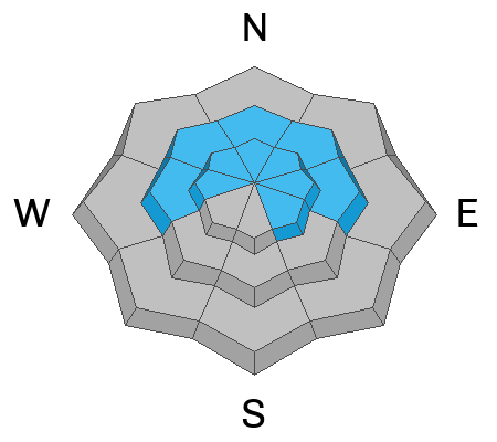
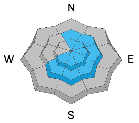
A CONSIDERABLE avalanche danger exists primarily on steep wind drifted northerly to easterly facing aspects at the upper elevations. Human triggered avalanches 1-3' deep are likely and may be triggered at a distance (remotely). Some natural avalanches are possible due to the wind. A MODERATE avalanche danger exists on all other mid-elevation slopes. Remember that traumatic injury is likely with any avalanche involvement this early season.
Low
Moderate
Considerable
High
Extreme
Learn how to read the forecast here
Special Announcements
The 5th Annual Avalanche Awareness Week is December 3-10. The week's goal is to save lives through activities that promote avalanche awareness, education, and safety. We have a variety of events around the state. Find an event near you.
Weather and Snow
The National Weather Service has issued a Winter Storm Warning for the mountains of northern and central Utah through Monday morning as a series of storms move through the region this weekend.

Welcome back, Winter.
As of 5am, storm totals are 6-10" of low density snow Mountain temperatures are in the teens at most locations and have dropped into the single digits up high. That's the end of the good news. Stop reading if you can't bear the bad.
The winds played the spoiler, picking up out of the west-northwest overnight, blowing 25-30mph with gusts to 50mph. The highest elevations have wind speeds of 50mph with gusts to 75. Adding insult to injury, the winds are blowing and drifting the low density snow at the mid-elevations as well. (The bad news is only getting started.)
For today, we'll see a bit of a lull in the snowfall though we could squeeze an additional 1-4" of new during the day. Temps will be in the teens. Winds will blow 25-30mph from the west-northwest.
For tonight, we transition to a strong wet, warm, and windy style of storm that will last through early Monday. Heavy snowfall (particularly in the Ogden area mountains) can be expected with the rain-snowline rising from the valleys to perhaps 6500'+, west-northwest winds averaging 45-50mph and temps warming to the mid-20s. Yuk. 15-25" of storm totals can be expected.
Clearing and diminishing winds are expected later Monday. A grazing storm rides to the north Thursday with another storm possible over the weekend.
Remember that snow coverage is still thin, with 1-3' of snow on the ground...and prior to this storm, many southerly aspects were bare.

The Salt Lake National Weather Service has an excellent collection of mountain weather forecasts and current conditions.
Recent Avalanches
No recent avalanches have been reported from the backcountry.

Two valuable observations from this past week give you an idea of the current snowpack structure:

Submit your snow and avalanche observation HERE.
Ad
Avalanche Problem #1
Persistent Weak Layer
Type
Location
Likelihood
Size
Description
You will be able to trigger 1-3' deep soft slab avalanches today that fracture within the old pre-existing snow. This old snow, consisting of a stacked mess of weak sugary facets, crusts and patches of feathery surface hoar (frost) has all the strength of a house of cards. In steep wind drifted terrain, you are likely to see shooting cracks, hear audible collapses and possibly trigger soft slab avalanches, even at a distance. It will be tricky and dangerous today.
The most dangerous slopes face northwest to east at the mid and upper elevations. West and southeast facing slopes are suspect as well. Treat any freshly wind loaded slope as dangerous.
Avalanche Problem #2
Wind Drifted Snow
Type
Location
Likelihood
Size
Description
Owing to the moderate to strong west-northwest winds, soft slab avalanches of fresh wind deposits may be found on a variety of aspects and elevations, but primarily on north to east to southerly facing slopes. Sensitive soft slabs be also be cross-loaded on other aspects, with loading patterns possible well down the slope. Look for and avoid thicker, stiffer, and chalky feeling drifts.
General Announcements
This information does not apply to developed ski areas or highways where avalanche control is normally done. This forecast is from the U.S.D.A. Forest Service, which is solely responsible for its content. This forecast describes general avalanche conditions and local variations always occur.