Forecast for the Provo Area Mountains

Greg Gagne
Issued by Greg Gagne for
Friday, December 1, 2023
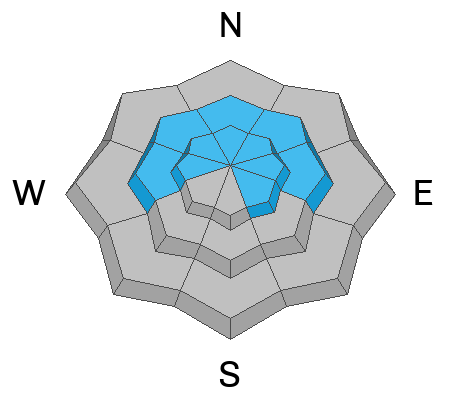
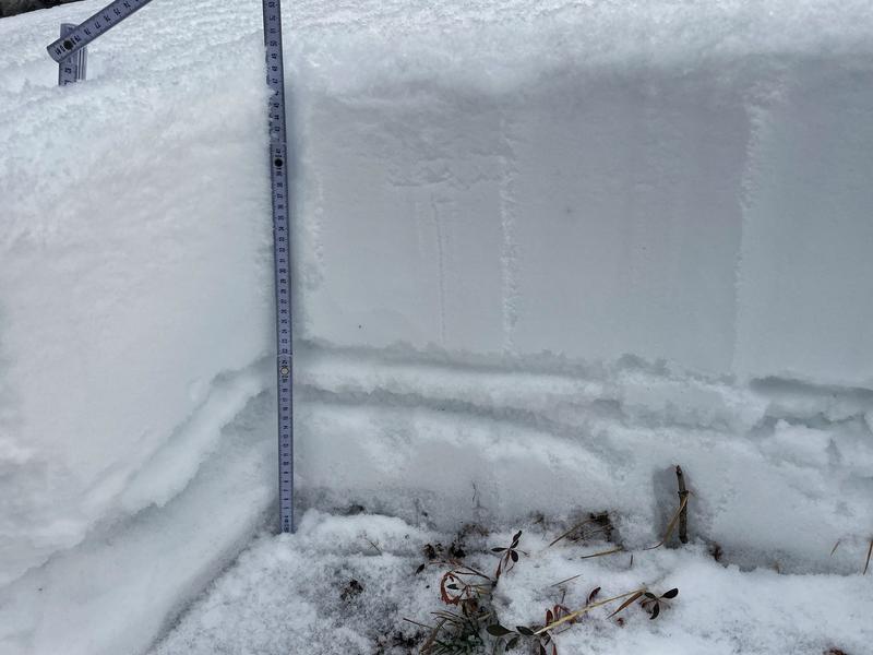
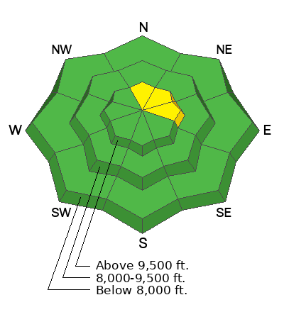
The avalanche danger will rise to MODERATE this afternoon on upper elevation slopes facing north and east with increasing snowfall and wind. Watch for rapidly changing conditions, especially during any period of heavier snowfall or increased winds.
The safest riding options will be on southerly-facing slopes where there are no buried weak layers.

Expect an increasing avalanche danger this weekend.
Low
Moderate
Considerable
High
Extreme
Learn how to read the forecast here
Special Announcements
As local skis areas open, or work towards opening, please be aware of uphill travel policies and respect their closures to keep you and their workers safe.
The 5th Annual Avalanche Awareness Week is December 3-10. The week's goal is to save lives through activities that promote avalanche awareness, education, and safety. We have a variety of events around the state. Find an event near you.
Weather and Snow
The National Weather Service has issued a Winter Storm Warning for the Provo mountains through Monday morning as a series of storms move through the region this weekend with two to three feet of snow expected by Monday.

6 AM: Light snowfall with temperatures in the mid-teens F. Winds are from the west and light at the low and mid elevations, with gusts in the 20's mph along the 11,000' ridges.
Today: Snowfall will increase mid-day with 2-4" of snow by nightfall. Winds will be from the west with mid-elevation speeds averaging in the low teens with gusts in the 20's mph with upper elevations averaging in the 20's with gusts in the 30's mph. Temperatures will be 15° - 20° F.
Tonight: Winds will become much stronger with gusts exceeding 50 mph and heavy snowfall.
Snow will continue through the weekend as a series of waves move through the region, with rising temperatures (and heavier and denser snow) on Sunday.

The Salt Lake National Weather Service has an excellent collection of mountain weather forecasts and current conditions.
Recent Avalanches
No recent avalanches have been reported from the backcountry.

Two valuable observations from this past week give you an idea of the current snowpack structure:

Submit your snow and avalanche observation HERE.
Ad
Avalanche Problem #1
Persistent Weak Layer
Type
Location
Likelihood
Size
Description
There is 2-3' of snow on mid and upper elevation shady aspects, with layers of crusts and weak faceted snow down near the ground as shown in the photo below. Over the past few weeks, there has been collapsing and cracking on this weak layer, and a large avalanche in the Birthday Chutes in White Pine Canyon in the Salt Lake mountains on November 25th failed on this layer of weak snow.
With heavy snowfall and strong winds expected through this weekend, avalanches are likely to fail on this weak layer.
  • This weak layer can be found on mid and upper-elevation aspects facing west, north, and east, including some upper-elevation aspects facing southeast.
  • Avalanches will be 2-3' deep and possibly over 100' wide.
  • Avalanches may triggered remotely or from lower-angled slopes.
General Announcements
Additional Information
  • It’s never too early to start thinking about avalanches. Here are a few things to consider doing:
  • Learn online. We have over 5 hours of free online learning at the Know Before You Go Website
  • Check out the upcoming in-person Know Before You Go events HERE
  • Sign up for an on-snow class
  • Check out the UAC's education progression HERE
  • Get your avalanche rescue gear ready for winter. Put fresh batteries in your transceiver and update the firmware. Inspect your shovel and probe. Get your airbag backpack ready by possibly doing a test deployment and updating the firmware if it is an electric version or getting your canister refilled if it's not electronic
This information does not apply to developed ski areas or highways where avalanche control is normally done. This forecast is from the U.S.D.A. Forest Service, which is solely responsible for its content. This forecast describes general avalanche conditions and local variations always occur.