UDOT PLANNED AVALANCHE CLOSURES!!

Forecast for the Provo Area Mountains

Evelyn Lees
Issued by Evelyn Lees for
Saturday, December 15, 2018
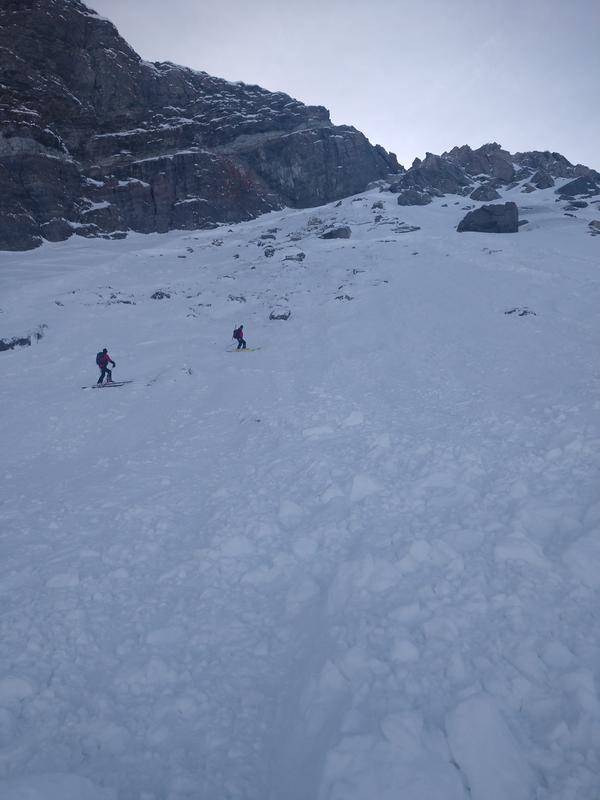
The avalanche danger is MODERATE for triggering a slab avalanche 2 to 4 feet deep, on mid and upper elevation slopes facing northwest through easterly, and on upper elevation west and southeasterly facing slopes. It is an isolated chance of triggering one of these monsters, but deadly if you do.
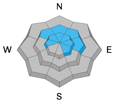
There is also a MODERATE danger for triggering a wind slab or wind drift, which are most widespread on upper elevation, northerly facing slopes.
Low
Moderate
Considerable
High
Extreme
Learn how to read the forecast here
Special Announcements
Empire at Deer Valley is closed to uphill traffic for the rest of the season due to explosive work and opening.
The new UAC IOS mobile app is now available on the app store. Check out the new "My Weather" feature.

Check out the new free online avalanche course series developed by the Utah Avalanche Center. This is a great way to refresh your skills or prepare you for a Backcountry 101 or Level 1 class.
Weather and Snow
Skies are clear, and it’s downright balmy this morning, with temperatures in the Provo area mountains in the 30s. The southerly winds got going late afternoon and peaked overnight, with the Provo mid elevation stations averaging 2 to 30 mph, gusting to 40. I would add 10 to 15 mph to the speeds for the upper elevations in the Provo area mountains. With speeds now on a downward trend, lots of sun and temperatures warming into the low to mid 30s, it’s going to be a very pleasant day in the mountains.
Snow depths are about 2 to 3 feet in the Provo area mountains, making packed roads and trails and grassy meadow the places to go. Sunny slopes will be very crusty early, softening later, and there is dense, creamy powder on the shady slopes.
Check out the Weekly Review by Greg Gagne for a round up of weather and avalanche activity.
Recent Avalanches
No new observations from the Provo area mountains. However, the snow pack is similar to that in the Salt Lake area mountains. Avalanches – in the upper Cottonwoods, small explosives triggered 2 large avalanches, both breaking near the ground in facets above the October rain crust. Deep and wide, they were on northeast facing slopes, at about 10,600’, and one was a “repeater” – on a slope that avalanched in late November. No avalanches were reported from the backcountry.
Note the people in the photo for scale and the rocky bed surface – these were big, deep slides.
Ad
Avalanche Problem #1
Persistent Weak Layer
Type
Location
Likelihood
Size
Description
The persistent weak layer is NOT totally dormant - upper elevation slopes facing northwest through northeast remain the bull-eye terrain where in isolated places a person could trigger a slab avalanche 2 to 4 feet deep. While the chance of triggering one of these deep slides has decreased with time, the size has not. A slide would likely be triggered from a shallower spot in the snow pack, and tracks on a slope do not indicate total stability of that slope. The overnight southerly winds added a little more weight to some of these slopes in the form of wind drifts. Steep, rocky northerly facing terrain with fresh wind drifts are particularly suspect, and even slopes that have already slid this season can slide again.
Avalanche Problem #2
Wind Drifted Snow
Type
Location
Likelihood
Size
Description
Overnight, the southerly winds drifted snow, especially along the high ridge lines and in open bowls. Look for clues you’re in the wind zone, such as an eroded patterned snow surface or new cornices and rounded, smooth drifts. These new wind slabs, or drifts, will be on the lee sides of ridge crests and around terrain features, like gully walls and sub ridges, especially at the upper elevations.
Clues recent wind erosion pattern (Kory Davis photo) and a cornice (Mark White photo)
General Announcements
This information does not apply to developed ski areas or highways where avalanche control is normally done. This forecast is from the U.S.D.A. Forest Service, which is solely responsible for its content. This forecast describes general avalanche conditions and local variations always occur.