Forecast for the Provo Area Mountains

Trent Meisenheimer
Issued by Trent Meisenheimer for
Sunday, December 16, 2018
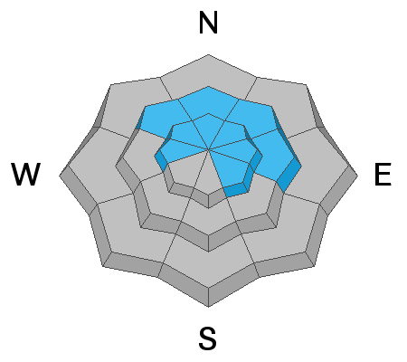
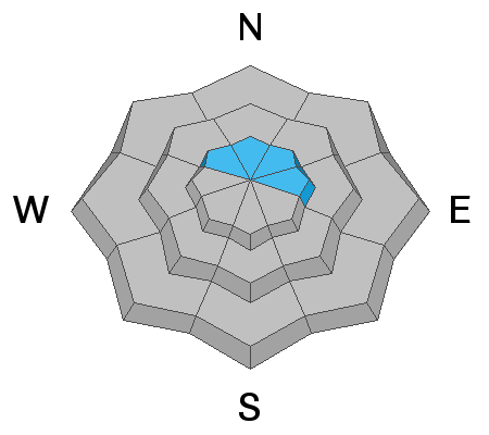
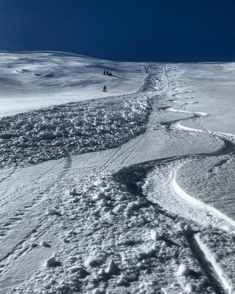
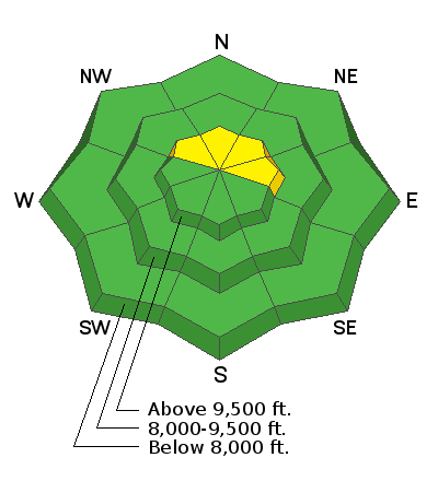
The avalanche danger is MODERATE for triggering a slab avalanche 2 to 4 feet deep, on upper elevation slopes facing northwest through easterly. It's an isolated chance of triggering one of these monsters, but deadly if you do. There is also a MODERATE danger for triggering a wind slab, which are most widespread on upper elevation, northerly facing slopes.
Low
Moderate
Considerable
High
Extreme
Learn how to read the forecast here
Special Announcements
Snowbird will be firing upon the Gad Valley/White Pine ridge this morning from 8:00am to 9:30am. Please stay clear of the avalanche workers and far off the ridgeline and any surrounding terrain until they are finished.
The new UAC IOS mobile app is now available on the app store. Check out the new "My Weather" feature.
Check out the new free online avalanche course series developed by the Utah Avalanche Center. This is a great way to refresh your skills or prepare you for a Backcountry 101 or Level 1 class.
Weather and Snow
Today, we will see a few high clouds along with warm and breezy conditions in the mountains as a storm approaches the west coast. Unfortunately, this storm splits as it moves overhead Utah on Monday. The storm may deliver a few inches of new snow on Monday if the northern piece sags far enough south. Southerly winds once again picked up last night around 11:00 pm and are currently blowing 15-20 mph gusting into the 30's across the high elevation terrain. If the valley haze and pollution isn't enough to convince you we are under a strong inversion the Temperatures should - 10,000' current temps are 30°F while here at the SLC office it's 26°F. Usually, temperatures cool with height, but in this case we have warmer (more buoyant) air over colder (more dense) air that gets trapped in the valleys.
Riding and turning conditions really took a hit by the southerly overnight winds on Friday. Most of the terrain has been wind damaged and only the most sheltered, shady, slopes have soft settled powder. Sunny slopes will support a melt freeze crust this morning that may or may not soften with today's heating. Snow depths are about 2 to 3 feet in the Provo area mountains, making packed roads and trails and grassy meadow the places to go.
Check out the Weekly Review by Greg Gagne for a round up of weather and avalanche activity.
Recent Avalanches
In the Provo area mountains a skier and a dog took a small ride in a wind slab while walking uphill. This wind slab was 70' wide and around a foot deep. The group decided not to head up any higher due to more consequential terrain above. All observations can be found HERE.
It's only been 36 hrs since the last report of 2 large avalanches, that were triggered with small explosives in the upper cottonwoods. Both of these avalanches could easily bury or kill a person. They were on northeast facing terrain, at about 10,600’ in elevation, failing on our persistent (faceted) weak layer, close to the ground. However, the snow pack is similar to that in the Salt Lake area mountains so these avalanches should apply to your terrain selection.
Ad
Avalanche Problem #1
Persistent Weak Layer
Type
Location
Likelihood
Size
Description
The persistent weak layer is NOT totally dormant - upper elevation slopes facing northwest through northeast remain the bull's-eye terrain. Where in isolated places a person could trigger a slab avalanche 2 to 4 feet deep. While the chance of triggering one of these deep slides has decreased with time, the size has not. A slide would likely be triggered from a shallower spot in the snow pack, and tracks on a slope do not indicate total stability of that slope. Steep, rocky, northerly facing terrain with fresh wind drifts are particularly suspect, and even slopes that have already slid this season can slide again.
Yesterday, my group dug four different snow-pits in upper Little Cottonwood Canyon (LCC) and all of our extended column test results we negative. To me this doesn't matter, I look more at the structure of the snowpack rather than the test results. If you dig on any shady mid-to-upper elevation slope you'll see what I am talking about. This poor snowpack structure as well as the avalanches triggered in upper LCC are enough to keep me off upper elevation steep, rocky, northerly facing terrain for now.
Photo: Heat map of all the avalanche activity from November 21st through December 16th. Notice how the bull's-eye terrain is upper elevation north and north east.
Avalanche Problem #2
Wind Drifted Snow
Type
Location
Likelihood
Size
Description
Overnight, the southerly winds picked up again and I am always shocked how the wind can find snow to drift, especially along the high ridge lines. Look for clues you’re in the wind zone, such as an eroded patterned snow surface or new cornices and rounded, smooth drifts. These new wind slabs, or drifts, will be on the lee sides of ridge crests and around terrain features, like gully walls and sub ridges, especially at the upper elevations.
Photo: Mark White, Park City ridge line. Small wind slab that was triggered naturally by a small cornice that fell.
General Announcements
This information does not apply to developed ski areas or highways where avalanche control is normally done. This forecast is from the U.S.D.A. Forest Service, which is solely responsible for its content. This forecast describes general avalanche conditions and local variations always occur.