Forecast for the Provo Area Mountains

Evelyn Lees
Issued by Evelyn Lees for
Friday, December 14, 2018
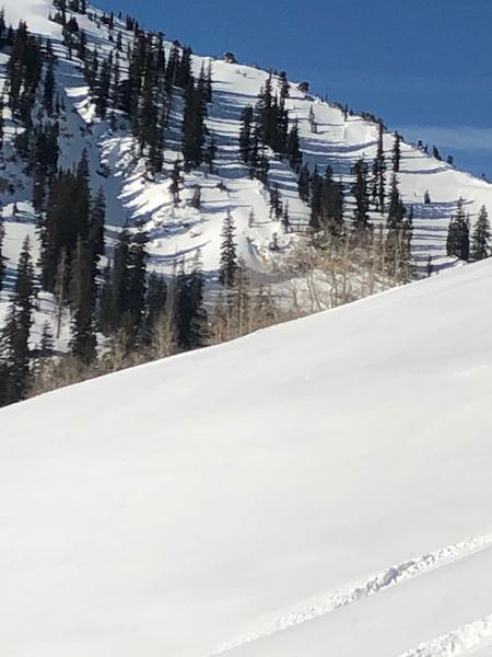
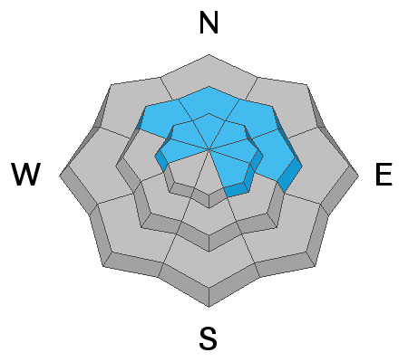
The avalanche danger is MODERATE on mid and upper elevation slopes facing northwest through easterly, and on upper elevation west and southeasterly facing slopes. Slab avalanches could break 2 to 4 feet deep, failing near the ground on weak, sugary facets.
  • Old wind drifts can still be triggered on steep slopes, and any new soft drifts from the afternoon winds will be easy to trigger.
  • Wet loose sluffs can be triggered on steep, sunny slopes if the snow becomes damp, serious if they push you over a rock band or into a gully.
  • Good news – Wednesday’s storm did a good job covering the old, tracked and worn out snow surface, and once again there’s plenty of excellent – and safer – riding on southerly and lower angle slopes.
Low
Moderate
Considerable
High
Extreme
Learn how to read the forecast here
Special Announcements
Deer Valley is closing Empire for uphill traffic for the rest of the season due to explosive work and opening.
The new UAC IOS mobile app is now available on the app store. Check out the new "My Weather" feature.

Check out the new free online avalanche course series developed by the Utah Avalanche Center. This is a great way to refresh your skills or prepare you for a Backcountry 101 or Level 1 class.
Weather and Snow
Under clear skies, mountain temperatures are a remarkable 10 to 15 degrees warmer than yesterday morning, mostly in the mid 20s, with a 10 degrees reading at Aspen Grove where the cold air is pooled. Westerly winds are light, averaging 10 to 15 mph at the mid elevations, closer to 20 mph across the highest peaks to the north. Temperatures, winds and clouds will all increase this afternoon, with highs near 40°F at 8,000’ and 30°F at 10,000’, and southwesterly winds averaging 15 to 25 mph, with gusts to 40 mph at the high elevations.
Recent Avalanches
Half a dozen smaller natural avalanches were noted in the backcountry, occurring during Wednesday’s windy storm. These were new snow slides on wind-drifted slopes, mostly along ridgelines. Several were reported from upper Snake Creek.
Below: you can just see a few small pockets, up to 100' wide. Upper Snake Creek
Ad
Avalanche Problem #1
Persistent Weak Layer
Type
Location
Likelihood
Size
Description
Upper elevation slopes facing northwest through northeast remain the bull-eye terrain for triggering a slab avalanche 2 to 4 feet deep. These slides are failing near the ground on the persistent weak layer of loose, sugary faceted snow. Wednesday’s new snow and wind added some extra weight to these slopes, especially those with an easterly component. Steep, rocky terrain in areas that received the most snow and wind (such as upper Little Cottonwood) are slopes more likely to slide. Even slopes that have already slid this season retained the weak faceted snow, and can slide again.
Avalanche Problem #2
Wind Drifted Snow
Type
Location
Likelihood
Size
Description
A few of Wednesday’s wind drifts and cornices can still be triggered. Smooth and rounded, the drifts are mostly along ridges and sub ridges. This afternoon’s increasing wind speeds could drift snow into new shallow, soft slabs on the lee sides of ridge crests and terrain features, especially at the upper elevations.
Photo below: Carey Pierce. Yesterday's wind drifting snow on Tempanogoos
Additional Information
As the day heats up, watch for the snow becoming damp on the steep sunny slopes. First clue will be swarms of roller balls, then small wet loose sluffs that can be pushed, fanning out below. Increasing clouds and winds should help cool the snow later this afternoon.
General Announcements
This information does not apply to developed ski areas or highways where avalanche control is normally done. This forecast is from the U.S.D.A. Forest Service, which is solely responsible for its content. This forecast describes general avalanche conditions and local variations always occur.