Forecast for the Provo Area Mountains

Greg Gagne
Issued by Greg Gagne for
Thursday, December 13, 2018
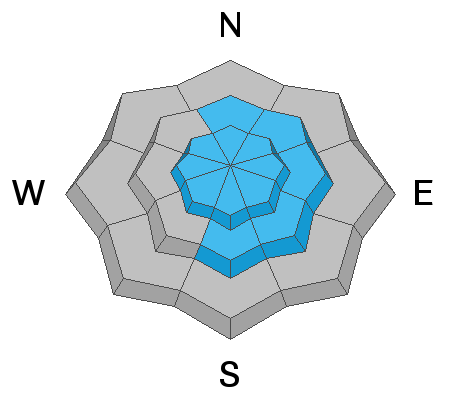
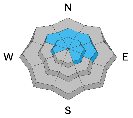
The avalanche hazard is Moderate for fresh wind drifts at the upper elevations, as well as mid elevations facing north, through east, and south. Also watch for large, sensitive cornices along upper elevation ridgelines. A pockety but severe Moderate danger exists for human triggered avalanches 2-4' deep into the old snow on westerly to northerly to easterly facing slopes at the mid and upper elevations. Continue to travel with extra caution. Otherwise the hazard is Low.
Low
Moderate
Considerable
High
Extreme
Learn how to read the forecast here
Special Announcements
The new UAC IOS mobile app is now available on the app store. Check out the new "My Weather" feature.

Check out the new free online avalanche course series developed by the Utah Avalanche Center. This is a great way to refresh your skills or prepare you for a Backcountry 101 or Level 1 class.
Weather and Snow
6" of snow were reported from the Provo mountains from Wednesday's storm, but it was the winds which were the highlight, with gusts in the 40's and 50's. Anemometer​​​s at 11,000' were gusting in the 90's mph. Winds have since subsided and are now generally light, blowing out of the south and southwest and gusting in the teens at the mid and upper elevations.
For today you can expect mostly sunny skies and light winds. Enjoy the fresh snow while you can as it does not appear there are any significant weather events for at least the next 7 days.
Recent Avalanches
No avalanche activity was reported from the Provo mountains. In the Salt Lake mountains (which received roughly twice the amount of the Provo mountains) there were reports of sensitive wind drifts and storm slabs, with natural avalanches reported during the mid-afternoon hours during the period of highest precipitation intensity. With clearing skies today, I wouldn't be surprised to see some evidence of small natural activity along steep, upper elevation ridges in the Provo mountains.
Ad
Avalanche Problem #1
Wind Drifted Snow
Type
Location
Likelihood
Size
Description
Wednesday's strong winds which persisted through roughly 6 pm have created fresh wind drifts on all aspects at the upper elevations, and at the mid elevations facing north through east through south. Although these should be less sensitive today, you may find reactive wind slabs up to 1' thick.
Avalanche Problem #2
Persistent Weak Layer
Type
Location
Likelihood
Size
Description
I don't think Wednesday's winds and small storm amounts were enough to reactivate what has become a mostly dormant avalanche problem except for perhaps some of the slopes that avalanched during and just after the Thanksgiving storms. Repeater slopes, as we call them, are avalanches that fail to remove all the weak layers when they run and can be problematic with additional loading.
Additional Information
Help us verify our forecasts and let us know what you see out and about in the backcountry. Trigger an avalanche? Hear a whumph? Submitting observations is easy. Click on Observations and Avalanches in the menu bar at the top or from the convenience of your smartphone. I'll run you through the smartphone observation in the video below.
General Announcements
This information does not apply to developed ski areas or highways where avalanche control is normally done. This forecast is from the U.S.D.A. Forest Service, which is solely responsible for its content. This forecast describes general avalanche conditions and local variations always occur.