UDOT PLANNED AVALANCHE CLOSURES!!

Forecast for the Provo Area Mountains

Drew Hardesty
Issued by Drew Hardesty for
Wednesday, December 12, 2018
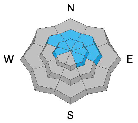
It'll be a day of rising avalanche danger. Many areas will start off with a LOW danger this morning. By late morning, the danger will trend toward MODERATE for new and developing wind drifts and new snow avalanches. Wind drifts will be more prominent on steep north to east to southeast facing slopes but also cross-loaded into gullies and couloirs...as well as other aspects. A pockety but severe MODERATE danger exists for human triggered avalanches 2-4' deep into the old snow on westerly to northerly to easterly facing slopes at the mid and upper elevations. Continue to travel with extra caution.
Low
Moderate
Considerable
High
Extreme
Learn how to read the forecast here
Special Announcements
The new UAC IOS mobile app is now available on the app store. Check out the new "My Weather" feature.

Check out the new free online avalanche course series developed by the Utah Avalanche Center. This is a great way to refresh your skills or prepare you for a Backcountry 101 or Level 1 class.
Weather and Snow
A sharp cold front is on the doorstep. I'll get right to the point. We can expect to see 2-5"+ in the mountains and finally get rid of the junk in the valleys. It's too much.
This morning, skies are overcast, temps are in the mid to upper 20s, and pre-frontal southwest winds are blowing 15-20mph with gusts to 30. The most exposed anemometers have wind speeds in the 30s, gusting to near 50.
Post-frontal, however, the winds veer back to the northwest and remain moderate to strong for much of the day...finally losing steam by late afternoon. It'll be a day of rising hazard.
Recent Avalanches
There were no reports of avalanche activity or other obvious signs of instability from the backcountry yesterday. Only along the Ogden skyline were avalanche control teams able to pry out some stiff and stubborn hard slabs with explosives.
I suspect there'll be more in this department for tomorrow's forecast.
Ad
Avalanche Problem #1
Wind Drifted Snow
Type
Location
Likelihood
Size
Description
Shallow but sensitive wind drifts may be found by the afternoon as the gusty northwest winds prevail upon the new low density snow. These will be sensitive to human weight and found to the lee of terrain features.
Avalanche Problem #2
Persistent Weak Layer
Type
Location
Likelihood
Size
Description
I don't expect there to be enough of a load to reactivate what has become a mostly dormant avalanche problem except for perhaps some of the slopes that avalanched during and just after the Thanksgiving storms. Repeater slopes, as we call them, are avalanches that fail to remove all the weak layers when they run and can be problematic with additional loading.
Additional Information
Help us verify our forecasts and let us know what you see out and about in the backcountry. Trigger an avalanche? Hear a whumph? Submitting observations is easy. Click on Observations and Avalanches in the menu bar at the top or from the convenience of your smartphone. I'll run you through the smartphone observation in the video below.
General Announcements
This information does not apply to developed ski areas or highways where avalanche control is normally done. This forecast is from the U.S.D.A. Forest Service, which is solely responsible for its content. This forecast describes general avalanche conditions and local variations always occur.