Forecast for the Provo Area Mountains

Dave Kelly
Issued by Dave Kelly for
Thursday, December 14, 2023
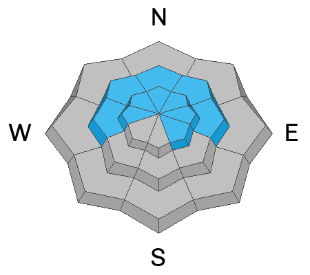
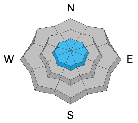
The avalanche danger is MODERATE on slopes over 30° in mid and upper west-north-east elevation and upper elevation southeast facing terrain. Areas with a thinner snowpack are where it would be possible to trigger an avalanche 1-3' deep failing into the older faceted snow. The avalanche danger is LOW at lower elevations and in mid-elevation southerly facing terrain.
Yesterday's strong winds transported loose surface snow into stiff wind-slabs. This problem will be easy to see; look for and avoid smooth, pillowy, or rounded piles of snow. Today, I will be staying away from steeper terrain (over 30°) with wind loading as an avalanche involving wind slabs on top of a PWL would be dangerous.
Low
Moderate
Considerable
High
Extreme
Learn how to read the forecast here
Weather and Snow
Under clear skies mountain temperatures are in the mid 20's °F. Winds have calmed down and are blowing lightly at most locations. There was no new snow reported overnight and snow heights range from 1-3' with isolated areas holding closer to 4' of snow. For today, winds will blow lightly from a westerly direction 5 gusting to 10 MPH at the 9,000' ridgelines and 15 gusting to 20 MPH at the 11,000' ridgelines. Skies will be clear with temperatures 32-35°F. No new snow is expected today or through the week as high-pressure builds, with the next shot of snow looking to be at least a week out. Read the weather forecast discussion HERE.
These weather conditions have and will continue to facet the surface snow (recycled powder) and you can expect to see loose dry avalanches in the steepest terrain on shady aspects. These small avalanches may not be enough to bury you, but could rake you through trees or over a cliff band. The good news is that this layer of faceted surface snow makes for soft turns.
Recent Avalanches
Yesterday ski areas reported wind-drifted snow avalanches with explosives on steep north-west facing aspects and on mid-pack facets on east and southeast aspects all above treeline. These pencil hard slab avalanches were failing 1-3' deep and up to 200' wide and are similar to what you might find in the higher elevation terrain in the Provo area mountains.
There were no new reports of avalanches from the backcountry yesterday. Read all the backcountry observations HERE.
Ad
Avalanche Problem #1
Persistent Weak Layer
Type
Location
Likelihood
Size
Description
Triggering an avalanche 1-3' deep down into our old PWL persistent weak layer of facets and crusts is becoming less likely.
Snow pits continue to show poor structure; cracking and collapsing have become much less common and not seeing these signs does not mean a slope is stable. Extended Column Tests from recent observations show stubborn propagation in snowpits throughout the range.
UAC forecaster Eric Trenbeath wrote a blog about his experience with PWL in the Wasatch Mountains that's worth reading about HERE.
Avalanche Problem #2
Wind Drifted Snow
Type
Location
Likelihood
Size
Description
Yesterday's winds transported snow onto leeward slopes in the upper elevations. I would look for this problem at all aspects above treeline as yesterday's strong winds swirled and loaded snow in strange patterns.
The stubborn nature of this problem could allow you to travel out into the middle of a slope before it breaks above you.
General Announcements
This information does not apply to developed ski areas or highways where avalanche control is normally done. This forecast is from the U.S.D.A. Forest Service, which is solely responsible for its content. This forecast describes general avalanche conditions and local variations always occur.