Forecast for the Provo Area Mountains

Dave Kelly
Issued by Dave Kelly for
Wednesday, December 13, 2023
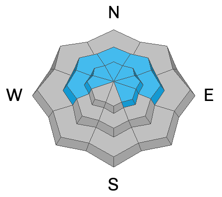
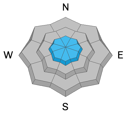
The avalanche danger is MODERATE on steep slopes in the mid and upper west-north-east elevation and upper elevation southeast facing terrain where it will be possible to trigger an avalanche 1-3' deep stepping into the old faceted snow from early season or trigger a wind-drifted snow avalanche in the highest elevation terrain.
Last night's easterly winds will have transported loose surface snow into stiff wind-slabs. Avoid smooth, pillowy, or rounded piles of snow in steep terrain as any wind-drifted avalanche could be the extra weight needed to trigger a deeper avalanche failing into old faceted snow.
The avalanche danger is LOW at lower elevations and in mid-elevation southerly facing terrain.
Low
Moderate
Considerable
High
Extreme
Learn how to read the forecast here
Weather and Snow
Under partly cloudy skies mountain temperatures are in the low 20's °F. Winds are blowing from an easterly direction 20 gusting to 25 MPH at the 8,000' ridgelines. There was no new snow reported overnight and snow heights range from 1-3' at most locations. For today, winds will blow from the east at the highest ridgelines before decreasing in speed by this afternoon. Skies will be clear with temperatures 33-37°F. No new snow is expected today or through the week as high-pressure builds, with the next shot of snow looking to be a week out.
These weather conditions will allow the surface snow to facet (recycled powder) and you can expect to see loose dry avalanches in the steepest terrain. These small avalanches may not be enough to bury you, but could rake you through trees or over a cliff band. The good news is that this layer of faceted surface snow will make for great travel conditions and fun sliding on lower angle slopes out of the wind zone.
Recent Avalanches
There were no reports of avalanche activity from the Provo mountains yesterday. Read all the observations HERE.
Ad
Avalanche Problem #1
Persistent Weak Layer
Type
Location
Likelihood
Size
Description
Triggering an avalanche 1-3' deep down into our old PWL persistent weak layer of facets and crusts is becoming less likely in most terrain.
While snow pits continue to show poor structure; cracking and collapsing have become much less common. I suspect that in the days ahead it will become harder to trigger this layer as reports come in of rounding facets in deeper snowpack areas.
I do think you would be more likely to trigger one of these avalanches in thinner snowpack areas (read more about avalanches that involve PWL's HERE).
Cracking and collapsing may or may not accompany unstable slopes.
Avalanche Problem #2
Wind Drifted Snow
Type
Location
Likelihood
Size
Description
Last night the winds blew from the east throughout the range and may have transported snow onto leeward slopes in the upper elevations. Keep an eye out for wind-drifted snow drifts that may look pillowy and round as these are areas where a small wind-drifted avalanche may step down to the deeper persistent weak layer triggering an avalanche 1-3' deep.
Additional Information
This is an excellent time to sharpen your avalanche rescue skills. Practice with your partners or take a companion rescue clinic.
General Announcements
This information does not apply to developed ski areas or highways where avalanche control is normally done. This forecast is from the U.S.D.A. Forest Service, which is solely responsible for its content. This forecast describes general avalanche conditions and local variations always occur.