Forecast for the Provo Area Mountains

Dave Kelly
Issued by Dave Kelly for
Sunday, January 28, 2024
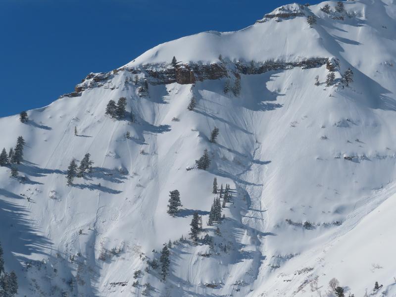
The avalanche danger is MODERATE today. Evaluate snow and terrain carefully to identify thin, rocky, steep areas where slab avalanches may fail in a persistent weak layer buried 2-5' deep.
Temperature affected slopes will start off with a LOW danger that will rise to MODERATE throughout the day with warming temperatures. If you start to see wet snow falling off of rocks or trees or are sinking up to your boot tops it's time to get off the slope.
Low
Moderate
Considerable
High
Extreme
Learn how to read the forecast here
Special Announcements
Join us for a Motorized Backcountry 101: Introduction to Avalanches class on February 2-3 down on the Skyline. Click HERE for more information.
Weather and Snow
This morning, under mostly clear skies temperatures are in the low to mid 30's °F. Winds are blowing from north in the single digits gusting to the teens MPH at the 8,000' ridgelines and from the east down canyon at the lower elevations. There was no new snow overnight.
For today, we should see mostly sunny skies with temperatures from 40°-45°F at 8,500'. Winds will blow from the north-northwest 5 gusting to 10 MPH at the 9,000' ridgelines and 20 gusting to 25 MPH at the 11,000' ridgelines. Winds are forecast to decrease throughout the day. This morning you may found a crusted surface on solar aspects and lower elevation terrain. These will be the first slopes to warm up and show signs of wet snow avalanche activity throughout the day.

Looking forward into the rest of the week we can expect to see above normal temperatures with clear skies. The next storm is on the horizon for the end of the week. Read more from our partners at the National Weather Service HERE.
Recent Avalanches
Yesterday, we had reports of wet loose avalanches in Upper Little Cottonwood Canyon, a rider triggered wind-drifted snow avalanche in Upper Big Cottonwood Canyon, dry-loose avalanches in Aspen Grove, and wet loose sloughs triggering soft slab avalanches on east facing Timpanogos. These reports are all consistent with a Moderate avalanche danger.
Photo of wet loose sloughs triggering soft slabs on east facing Timpanogos. These avalanches ran between 1,000' and 2,500' vertical (Photo: Woody)
Click here for all recent observations and avalanches.
Ad
Avalanche Problem #1
Persistent Weak Layer
Type
Location
Likelihood
Size
Description
These avalanches involving buried persistent weak layers are not to be fooled with; if it's a thin snowpack over steep rocky terrain then you're taking a gamble. While the danger may have dropped from Considerable to Moderate the mountains don't care what the avalanche forecast is. For today, I will still be assessing terrain and avoiding zones that are steep and rocky with dry facets now buried close to the ground as these are the areas where you are more likely to trigger an avalanche.
Avalanche Problem #2
Wet Snow
Type
Location
Likelihood
Size
Description
Yesterday's wet loose activity was a precursor to today's warming. With light winds, less cloud cover and a freezing level forecast to hover at 9,000' the snow surface will heat up rapidly. If you start to see wet snow falling off of rocks, roofs, or trees, or start to sink to your boot tops then it's time to get off of and avoid steep slopes in the sun. The snow doesn't like rapid change and there is a chance that melting water could percolate down and cause some funny business with the facets near the ground at mid and lower elevations. For this reason, steep areas with a poor snowpack structure (PWL) are places I would avoid as the surface snow starts to break down throughout the day. The good thing about this particular problem is that your travel plans and choices make this an easy problem to avoid.
Additional Information
Nikki and Greg discuss the forecaster mindset when moving to a Moderate Danger with a buried Persistent Weak Layer (PWL)
Eric Trenbeath (Moab Avalanche Forecaster) put together a great blog discussing Moderate Danger with a buried Persistent Weak Layer. Read it HERE.
General Announcements
This information does not apply to developed ski areas or highways where avalanche control is normally done. This forecast is from the U.S.D.A. Forest Service, which is solely responsible for its content. This forecast describes general avalanche conditions and local variations always occur.