Forecast for the Provo Area Mountains

Trent Meisenheimer
Issued by Trent Meisenheimer for
Thursday, January 10, 2019
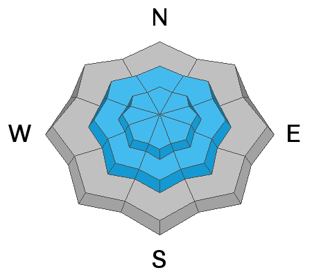
Today the avalanche danger is CONSIDERABLE on steep mid and upper elevation slopes for triggering new drifts of wind blown snow, which will be most widespread on the north 1/2 of the compass and for triggering new snow slides breaking on the old snow surface. In isolated locations with a thin snowpack avalanches could break near the ground, mostly likely where they have a new load of wind drifted snow. Keep it simple and avoid all avalanche terrain. Stick to terrain less than 30° degrees in steepness and have nothing steep above or adjacent to you.
Low
Moderate
Considerable
High
Extreme
Learn how to read the forecast here
Special Announcements
Drew Hardesty just released the first UAC podcast of the 2018/2019 season about "Guilt". As always Drew's insights are inspiring and thought provoking. Check it out HERE. Can't wait to see what else he has up his sleeve for this season.
Weather and Snow
This morning, we will see increasing clouds ahead of a very weak storm system that will cross Northern Utah this afternoon. Southerly winds are currently blowing 20-25 mph gusting into the 40's across the high elevation ridge lines. Lose some elevation and winds are more reasonable and in the 10-15 mph range. Current mountain top temperatures hover in the mid 20's °F. Temperatures will be dropping throughout the day as the weak cold front slices overhead early afternoon. Winds are expected to die down later in the afternoon and switch to the northwest and we can cross our fingers for a trace to 2" of snow by tomorrow morning. Sigh.
In Mark White's observation yesterday from SLC he used the words " windjacked, inverted, slabby and sustrugi all come to mind" to described the snow surface. Some riders found soft settled powder in between the wind board and stiffer snow on the wind protected shady slopes. The sunny slopes will have a crust this morning that will likely not soften with today's winds and cooling temperatures.
Recent Avalanches
No new avalanche activity was reported from the backcountry yesterday. However, photos from the impressive natural avalanche cycle from the weekend continue to stream in. Widespread natural avalanches occurred in the Provo area mountains the past few days, on many aspects and elevations, including mid and low elevations.
Wilson and Covington have a great observation from their outing yesterday found HERE.
Photo: Natural avalanche cycle from the January 5-7th storm. Impressive!
Ad
Avalanche Problem #1
Wind Drifted Snow
Type
Location
Likelihood
Size
Description
The southerly winds has been relentless over the past 24 hrs. Average wind speeds across the high elevations have been in the 20-25 mph range gusting into the 30's and 40's. This has created fresh drifts of wind blown snow off the ridge lines and well down into the mountain valleys. Winds in the mountains often swirl around in the terrain and can cross load gullies, adjacent sub ridges and mid-slope break overs. Watch for and avoid being on any hard drifts of wind blown snow in any steep terrain today. These wind slabs have the potential to bury a human.
Avalanche Problem #2
Persistent Weak Layer
Type
Location
Likelihood
Size
Description
It's very complicated in the Provo mountains - there is weak, sugary faceted snow found in the mid snowpack and near the ground that was buried over the weekend by dense, heavy, wind driven snow. In places there was over 40" inches of new snow containing 5" inches of water weight that was added to the snowpack with the recent storm. THAT'S A HUGE LOAD. Even without a weak layer in the snowpack, it would take days for the snowpack to adjust to this much weight.
For now it's best to avoid any steep terrain in the Provo mountains at all elevations and aspects. Human triggered avalanches are likely and dangerous avalanche conditions exist, careful snowpack evaluation and cautious route-finding and conservative decision making is essential. Keep it simple and avoid all avalanche terrain. Stick to terrain less than 30° degrees in steepness and have nothing steep above or adjacent to you.
General Announcements
This information does not apply to developed ski areas or highways where avalanche control is normally done. This forecast is from the U.S.D.A. Forest Service, which is solely responsible for its content. This forecast describes general avalanche conditions and local variations always occur.