Forecast for the Ogden Area Mountains

Greg Gagne
Issued by Greg Gagne for
Friday, February 15, 2019
The avalanche hazard is CONSIDERABLE at mid and upper elevations where heavy snowfall and strong winds have created dense storm and wind slabs. At low elevations the hazard is MODERATE, where human-triggered loose wet avalanches are possible. Additionally, many homes and building in the Ogden Valley have deep snowpacks on their roofs. Avoid being underneath any steep roof with a load of snow.
The best - and safest - terrain today will be wind-sheltered, lower-angled slopes above about 7500' where the dense snow will be soft and supportable.
Expecting a rising avalanche hazard by later in the day with increasing winds and snowfall, with the hazard possibly reaching HIGH by later in the day or early evening.
Low
Moderate
Considerable
High
Extreme
Learn how to read the forecast here
Special Announcements
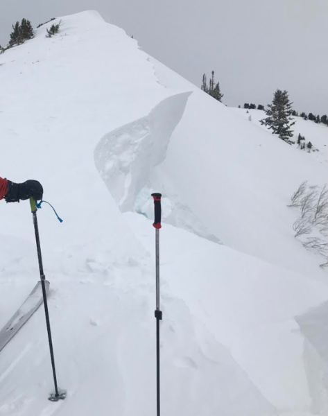
The accident reports for the four avalanche fatalities are all finalized and worth reading. We all have something to learn so that we can get home safely to our loved ones.
Jan 18 Electric Lake Report (Skyline area)
Jan 25 Laurel Peak Report (Moab area)
Feb 7 Circleville Mtn Report (Southwest area near Beaver)
Feb 9 Chalk Creek Report (Western Uintas)
The latest UAC Podcast was just released: The Message and the Messengers - A Conversation with Alex Hamlin. In this podcast, we sit down with Alex Hamlin. For over fifteen years, Alex Hamlin has worked at the intersection of storytelling and outdoor sport, with experience at magazines, global retail brands and creative agencies..
Weather and Snow
Currently: An additional 4-6" of snow fell overnight, containing about an inch of water. Storm totals since Wednesday are 20-24" with 3-4.5" of water. Yesterday's rain/snow line was about 7500'. Fortunately temperatures have begun to decrease after the very mild day on Thursday, and most mountain temperatures are in the 20's F, with a few low elevation stations still in the low 30's F. Many anemometers have rimed, so gauging winds is difficult, but winds are out of the south/southwest and have diminished overnight, with averages in the teens at the few stations still reporting wind speeds.
Today/Tonight: South/southwest winds should continue to remain light this morning, but increase in speed this afternoon ahead of a strong cold front this evening when they switch to the northwest. Temperatures will be in the 20's and low 30's. Snowfall should begin later this afternoon, with 6-10" possible by Saturday morning.
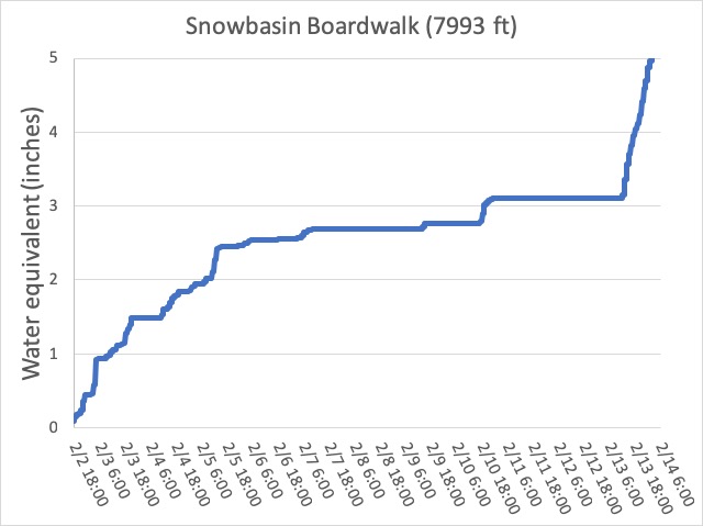
It has been a wet February so far! The graph below from 8000' at Snowbasin shows 5" of accumulated water since the beginning of the month (although add an inch to those numbers fro overnight). It has also been quite windy, with several long-duration wind events from the south/southwest. This combination of wind and water weight has put a significant load on the snowpack.
Recent Avalanches
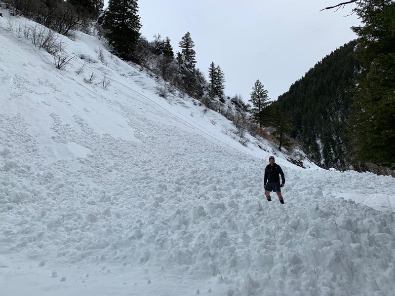
9 am update - wet loose slab avalanche from yesterday. Photo below. Perhaps below 6,000'. Mitigation at Ogden-area resorts reported widespread sensitive storm snow and wind slabs during the day on Thursday, with patrollers taking short rides. The rain and warm temperatures produced a natural cycle of loose wet avalanches at lower elevations yesterday morning.
Wheeler Canyon, Don Mueller photo
Ad
Avalanche Problem #1
Wind Drifted Snow
Type
Location
Likelihood
Size
Description
Strong winds out of the south/southwest created sensitive wind drifts on Thursday and overnight. Although these drifts are likely to be less sensitive today, they should still be avoided and given time to settle. Cornices are also very large and may break back much further than expected. A party in the Salt Lake mountains was surprised by how large and far back these cornices can break (observation).
Avalanche Problem #2
New Snow
Type
Location
Likelihood
Size
Description
The touchy storm snow from yesterday should have mostly settled out, but the 3-4"+ of water weight in the past two days is a very rapid load, and I would give the snowpack further time to adjust. Although I think sensitivities will occur within the storm and wind-blown snow, on my field day in the Ogden mountains on Tuesday I was finding isolated areas above 8000' with a thinner snowpack where there were weak facets down near the ground. I do think this issue is isolated, but any slide breaking down to the ground would be 3-4' deep.
Avalanche Problem #3
Wet Snow
Type
Location
Likelihood
Size
Description
With cooling temperatures beginning today the saturated snowpack at lower elevations should begin to freeze and lock up, but human-triggered loose wet avalanches are still possible below about 7000'. Also avoid low elevation terrain traps.
There were reports of "roofalanches" from Thursday where rain and warm weather caused some roofs to shed their entire snowpack, with large debris piles. Avoid being underneath any steep roofs that have a load of snow. Parents - please make note of this and make sure your kids do not play in the snow underneath any steep roofs.
General Announcements
This information does not apply to developed ski areas or highways where avalanche control is normally done. This forecast is from the U.S.D.A. Forest Service, which is solely responsible for its content. This forecast describes general avalanche conditions and local variations always occur.