Forecast for the Ogden Area Mountains

Greg Gagne
Issued by Greg Gagne for
Thursday, February 14, 2019
Heavy snowfall and strong winds has elevated the avalanche hazard, and the danger is HIGH at upper elevations, and CONSIDERABLE at mid and lower elevations. There are many different avalanche concerns for today, including fresh wind-drifted snow at the mid and upper elevations, storm snow at all elevations, and wet snow at low and mid elevations. Cautious terrain selection is crucial today - avoid being on or underneath slopes steeper than about 30 degrees. Additionally, many homes and building in the Ogden Valley have deep snowpacks on their roofs. Today's warming weather may cause these roofs to shed their entire snowpack, so avoid being underneath any steep roofs that have a load of snow.
The best - and safest - terrain today will be wind-sheltered, lower-angled slopes above about 7500'
Low
Moderate
Considerable
High
Extreme
Learn how to read the forecast here
Avalanche Warning
THE FOREST SERVICE UTAH AVALANCHE CENTER IN SALT LAKE CITY HAS ISSUED A BACKCOUNTRY AVALANCHE WARNING.
* TIMING...IN EFFECT THROUGH FRIDAY MORNING
* AFFECTED AREA...ALL THE MOUNTAINS OF NORTHERN AND CENTRAL UTAH, TO INCLUDE THE BEAR RIVER AND WASATCH RANGE, THE WESTERN UINTAS, AND THE MANTI-SKYLINE PLATEAU.
* AVALANCHE DANGER...STRONG WINDS ALONG WITH HEAVY DENSE SNOW ALONG WITH RAIN-ON-SNOW AT THE LOWER ELEVATIONS WILL CREATE DANGEROUS AVALANCHE CONDITIONS AND A HIGH AVALANCHE DANGER
* REASON/IMPACTS...NATURAL AND HUMAN TRIGGERED AVALANCHES WILL BE LIKELY ON MANY ASPECTS AND ELEVATIONS
Special Announcements
The accident reports for the four avalanche fatalities are all finalized and worth reading. We all have something to learn so that we can get home safely to our loved ones.
Jan 18 Electric Lake Report (Skyline area)
Jan 25 Laurel Peak Report (Moab area)
Feb 7 Circleville Mtn Report (Southwest area near Beaver)
Feb 9 Chalk Creek Report (Western Uintas)
The latest UAC Podcast was just released: The Message and the Messengers - A Conversation with Alex Hamlin. In this podcast, we sit down with Alex Hamlin. For over fifteen years, Alex Hamlin has worked at the intersection of storytelling and outdoor sport, with experience at magazines, global retail brands and creative agencies..
Weather and Snow
Since yesterday the Ogden mountains have picked up 12-18" of heavy dense snow, containing about 2" of water. Ben Lomond has the highest water totals, with 3.5" of water at 8000'. Overnight there were periods of strong winds out of the south/southwest, gusting into the 40's and 50's mph, and although winds have subsided somewhat this morning, some upper elevation stations are averaging in the teens with gusts in the 30's mph out of the south/southwest.
Temperatures have been rising overnight, and are now in the mid to upper 20's F at most mountain locations, with some stations just around freezing.
Any snowfall for today should be light, and temperatures will warm well into the 30's at lower elevations, and just around freezing along upper elevation ridgelines. Upper elevations could see and additional 1-4" of dense snow today. The rain/snow line will be rising, with low and mid elevation light rain possible today. Winds will be moderate and out of the south/southwest.
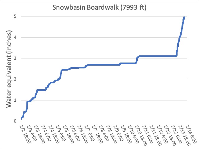
It has been a wet February so far! The graph below from 8000' at Snowbasin shows 5" of accumulated water since the beginning of the month. It has also been quite windy, with several long-duration wind events from the south/southwest. This combination of wind and water weight has put a significant load on the snowpack.
Recent Avalanches
Ongoing mitigation work at Ogden resorts yesterday reported touchy storm snow, especially during periods of heavier precipitation and wind. We received no reports from the backcountry, but I wouldn't be surprised if some small pockets of storm snow on steep slopes naturally avalanched.
UPDATE 0800: Check out this observation that we received this morning of wet snow avalanches at 7500 feet in Mill Creek Canyon (West Porter Fk). This is relevant for many areas in the Ogden area.
Ad
Avalanche Problem #1
Wind Drifted Snow
Type
Location
Likelihood
Size
Description
Strong winds yesterday and overnight have created fresh, dense drifts on many mid and upper elevation slopes. These drifts will primarily be found on aspects facing northwest through east, but cross-loading may drift snow on any aspect. Although these drifts may be less sensitive today, I would still avoid any steep, wind-drifted slope.
Avalanche Problem #2
New Snow
Type
Location
Likelihood
Size
Description
The touchy storm snow from yesterday should have mostly settled out, but the 2"+ of water weight since yesterday is a very rapid load, and I would give the snowpack time to adjust. Although I think sensitivities will occur within the storm and wind-blown snow, on my field day in the Ogden mountains on Tuesday I was finding isolated areas above 8000' with a thinner snowpack where there were weak facets down near the ground. I do think this issue is isolated, but any slide breaking down to the ground would be 3-4' deep.
Avalanche Problem #3
Wet Snow
Type
Location
Likelihood
Size
Description
The heavy dense snow since yesterday will warm today, and rain is possible up to about 7000', although possibly higher. Loose, avalanching from wet snow sluffs and denser slabs of heavy snow may be possible, including possible natural avalanching. Avoid being underneath any steep slopes, especially at low and mid elevations.
General Announcements
This information does not apply to developed ski areas or highways where avalanche control is normally done. This forecast is from the U.S.D.A. Forest Service, which is solely responsible for its content. This forecast describes general avalanche conditions and local variations always occur.