Join us for the 33rd Backcountry Benefit - Get Your Tickets Now!

Forecast for the Ogden Area Mountains

Nikki Champion
Issued by Nikki Champion on
Saturday morning, February 14, 2026

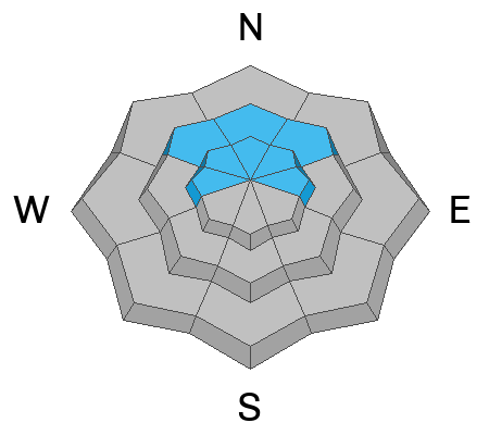
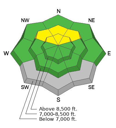
A MODERATE avalanche danger exists at upper elevations and on some mid-elevation slopes. Soft slabs in these areas are 6 to 14 inches thick, up to 100 feet wide, and may be triggered from a distance. While isolated slabs exist on a range of aspects, they are most likely on northwest through northeast facing slopes, where new or wind-drifted snow sits atop weak January facets.

Northern portions of the Ogden zone that received higher snow and water totals may hold slightly thicker, more reactive slabs, creating a higher danger than surrounding terrain.

Watch for signs of wet avalanche activity as temperatures rise and the sun becomes more direct through the day.
Low
Moderate
Considerable
High
Extreme
Learn how to read the forecast here
Special Announcements

Join the UAC for the first "Stay and Play Avalanche Course" at Bear River Lodge in the Uintas, March 19th-22nd. This course is designed for snowmobilers by snowmobilers, where you will learn avalanche rescue, riding skills, and how to survive in the backcountry. Come enjoy all the luxury offerings at Bear River Lodge and improve your skills along the way. Find more info HERE.

Weather and Snow

This morning, skies are mostly clear and temperatures are in the upper teens to low 20s °F. Winds are generally light and have shifted to a more southwesterly direction across much of the Ogden area mountains.

Today, skies will be mostly sunny this morning, with a chance of building high clouds this afternoon, especially in the northern Ogden region. Temperatures will climb into the mid 30s °F. Winds will remain light from the west. Generally clear weather is expected through the weekend, though clouds will gradually increase ahead of the next series of storms arriving late Sunday into Monday.

The storm arrived warm and intense on a southwest flow, and the dense new snow significantly improved riding conditions in upper elevation polar terrain. That is where the best conditions remain. On solar aspects and at mid elevations, conditions are still firm and variable, so lower angle terrain is the better choice.

Recent Avalanches

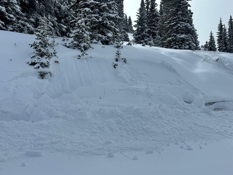
Yesterday, after the Northern Ogden zone was favored, multiple parties traveled in the Monte Cristo zone, myself included. We all observed a similar setup, with slightly less reactive snow than the previous day, but still noted a weak interface with easy cracking and propagation at the faceted new snow–old snow boundary. See the photo below from Monte Cristo, showing 10–12" of new snow sitting atop weak faceted snow. (M. Davis)

From North Ogden Divide to Chilly Peak between 6,500 and 8,500 feet, primarily on southeast through northeast aspects, several natural avalanches (SS N R1 D1) were observed on steep east through north-facing slopes, mostly below cliff bands. These likely occurred during the previous day’s warming event and in some cases stepped down to a mid storm density change or the new snow old snow interface.

Ski resort patrol work produced avalanches up to D2 that failed on January facets near the new-snow-old-snow interface. Remote triggers and additional natural activity were also reported.

You can view all recent observations here.

Avalanche Problem #1
Persistent Weak Layer
Type
Location
Likelihood
Size
Description

The most suspect terrain remains true north and northeast aspects, where soft slabs are breaking at the new snow old snow interface, especially in areas of the Northern Ogden Range that received higher water totals, such as Powder Mountain or the Monte Cristo Zone.

A cohesive soft slab 6 to 14 inches thick sits over weak, sugary facets that formed during the January drought. Hand pits, test slopes, and recent avalanche activity continue to show the same structure: dense new or wind-drifted snow resting on weak facets. It is a straightforward setup and remains unstable. Human triggered avalanches are still possible on steep northerly-facing terrain at upper elevations and down into some mid-elevations in favored areas.

While the problem is primarily on northerly aspects, the underlying weak structure exists across the northern half of the compass, west through east. With additional loading expected next week, the problem could expand onto a broader range of terrain.

Cracking and collapsing may be less common today, and that limited feedback can create a false sense of security. These slabs can still fail on the persistent weak layer and may be triggered from a distance. Treat steep north half terrain with caution, especially slopes that have seen recent wind loading.

Additional Information
General Announcements

This information does not apply to developed ski areas or highways where avalanche control is normally done. This forecast is from the U.S.D.A. Forest Service, which is solely responsible for its content. This forecast describes general avalanche conditions and local variations always occur.