Forecast for the Ogden Area Mountains

Nikki Champion
Issued by Nikki Champion on
Friday morning, February 13, 2026

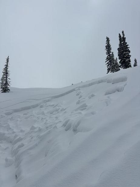
A MODERATE avalanche danger exists at mid and upper elevations, primarily on slopes with recent wind-drifted snow. Soft slabs in these areas are 6 to 12 inches thick, up to 100 feet wide, and can be triggered from a distance. While isolated slabs exist on a variety of aspects, the most likely slopes are northwest through east-facing, where new or wind-drifted snow sits on weak January facets.

Northern parts of the Ogden zone that received heavier snow and water totals yesterday may have slightly thicker, more reactive slabs, creating a bit higher danger than surrounding terrain.

Keep an eye on the sun and warming temperatures for signs of wet avalanche activity as the day heats up.

Low
Moderate
Considerable
High
Extreme
Learn how to read the forecast here
Weather and Snow

This morning, skies are broken and temperatures are in the upper 20s to low 30s °F. Winds are generally light and have shifted more east and southerly across much of the Ogden area mountains. The northern Wasatch picked up an additional 2 to 6 inches of snow yesterday, favoring the Powder Mountain area, bringing final storm totals to 4 to 13 inches.

Today, skies will become mostly sunny, with temperatures lingering in the low to mid 30s °F. Winds will remain generally light from the west. We should see some clearing through the early part of the weekend before the next series of storms arrives later Sunday into Monday.

The storm came in hot and heavy on a southwest flow, and that dense new snow brought skiing back to life in the upper elevation polar terrain. That is where you will find the best conditions right now. On the solar aspects and at the mid elevations, you are still scraping around on coral, so sticking to lower-angle terrain is the better move.

Recent Avalanches

No new reports came in from the backcountry, but ski resort control work and local guide services gave us a good look at how the snowpack is behaving.

Teams triggered multiple D1 to D1.5 avalanches with ski cuts and a few remote triggers on north and northeast aspects between 7500 and 8500 feet. These were generally 20 to 40 cm deep. Cracking and collapsing were widespread while skinning, showing the upper snowpack remains reactive. Explosives produced limited results overall, though a few small avalanches pulled out near rock bands where graupel had pooled.

Snowpit results continue to reflect this structure. A north-facing pit at 8200 feet produced an ECTP 6, failing 30 cm down and propagating on a weak layer within the upper snowpack. At 8880 feet on a north aspect, test slopes were reactive, breaking as soft slabs failing on top of the January facets.

You can view all recent observations here.

Avalanche Problem #1
Persistent Weak Layer
Type
Location
Likelihood
Size
Description

The most suspect terrain this morning is isolated to true north and northeast aspects, where soft slabs are breaking at the new snow old snow interface. Especially in areas that received higher water numbers, such as Powder Mountain.

A cohesive soft slab 6 to 12 inches thick sits over the weak, sugary facets that formed during the January drought. Hand pits and test slopes make the structure obvious: dense new or wind-drifted snow resting on top of weak facets. It is not a complicated setup, and it remains unstable. Human-triggered avalanches are still possible today on steep northerly-facing terrain at the upper elevations and on northwest through northeast aspects at the mid elevations.

That said, the underlying weak structure still exists on all north half aspects. With additional loading expected next week, this problem could easily expand back onto a broader range of terrain.

Cracking and collapsing will likely be less common today, and that limited feedback can create a false sense of security. These slabs can still fail on the persistent weak layer and may be triggered from a distance. Treat all steep north half terrain with suspicion, especially slopes that have seen recent wind loading.

Additional Information
General Announcements

This information does not apply to developed ski areas or highways where avalanche control is normally done. This forecast is from the U.S.D.A. Forest Service, which is solely responsible for its content. This forecast describes general avalanche conditions and local variations always occur.