Forecast for the Ogden Area Mountains

Mark Staples
Issued by Mark Staples for
Monday, December 12, 2022
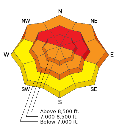
Strong south winds followed by a heavy snowfall have overloaded northerly facing and east-facing slopes at mid and upper elevations where avalanches are likely today, and the avalanche danger is HIGH. Low elevations at these same aspects have a CONSIDERABLE danger.
Mid and upper elevations facing southerly and west also have a CONSIDERABLE danger.
The danger is MODERATE at low elevation, southerly facing and west-facing slopes where there are no buried weak layers in the snowpack.

Travel advice is really simple today - stay off of any slope steeper than 30 degrees. Also, don't be under slopes steeper than 30 degrees. Even small slopes at low elevations can produce an avalanche if they are steeper than 30 degrees.
Low
Moderate
Considerable
High
Extreme
Learn how to read the forecast here
Avalanche Warning
What: Very dangerous avalanche conditions exist and the avalanche danger is HIGH
When: From 6am MST Monday morning to 6am MST Tuesday
Where: For the Wasatch Mountains north of I-80 and the Bear River Range.
Impacts: Very strong south winds and heavy snowfall have overloaded the snowpack creating unstable conditions. Avalanches are likely even at low elevations and on small slopes. Stay off of and out from under slopes steeper than 30 degrees.
Weather and Snow
Snowfall started late yesterday afternoon. As of 6 a.m. 15 inches of snow (1.5 - 1.7 inches of water) has fallen in the Ogden area mountains, and it's still snowing. Prior to this snowfall, very strong winds were blowing from the south. On Ogden Peak yesterday, winds were averaging 40-50 mph gusting to 60 mph. Other places had south winds averaging 15-30 mph gusting to 40 mph.
This morning, winds have shifted and are blowing from the southwest 10-15 mph gusting to 20 mph. Temperatures dropped into the mid-teens F around 9000 ft.
Today, snowfall should continue but become much lighter with less water content. Another 3-6 inches of snow should fall today and tonight. Temperatures may only warm a few degrees and winds will mostly be light and come from the west.
Recent Avalanches
No new avalanche activity was reported from the Ogden area, but I expect that to change today.
Ad
Avalanche Problem #1
Persistent Weak Layer
Type
Location
Likelihood
Size
Description
There is a buried persistent weak layer of faceted snow (and some surface hoar) throughout the Ogden area mountains. This layer is now buried 2-5 feet deep, and it is stressed by last night's snowfall making avalanches likely. Avalanches can be triggered being on, under, or just near a slope.
Yesterday's strong winds from the south starting loading northerly facing slopes before snowfall even started adding a lot of weight and stress to this buried layer. Avalanches in these areas will be large hard slabs. On sheltered slopes not loaded these winds, avalanches on this weak layer will be easily triggered soft slabs. On southerly and west facing slopes, this layer exist, but avalanches are slightly less likely because there is a hard ice crust above the weak layer.
The bad news - this layer will be dangerous and unstable for the near future. The good news - as this layer is buried deeper, it can slowly start to heal, but that won't happen this week.
Avalanche Problem #2
New Snow
Type
Location
Likelihood
Size
Description
There is simply a lot of new snow which can produce soft slab avalanches or loose avalanches (aka sluffs) on it's own. This avalanche problem will be short lived and can begin stabilizing as soon as snowfall ends. This avalanche problem exists on all slopes but is overshadowed by the persistent weak layer problem that will produce much larger and more dangerous avalanches.
Additional Information
For a detailed history of the snow and weather as of Dec 4th, visit our blog page HERE.
Check out this forecast discussion. If it's confusing, that's the point. The snowpack is dangerous, tricky and not to be trusted.
General Announcements

This information does not apply to developed ski areas or highways where avalanche control is normally done. This forecast is from the U.S.D.A. Forest Service, which is solely responsible for its content. This forecast describes general avalanche conditions and local variations always occur.