Many ski areas are now closed to uphill travel in order to prepare for winter operations. Resort uphill travel policies can be found
HERE. As of 5am, skies are clear with mountain temps in the low 20s up high, the upper teens down low. Overnight, the winds backed to the south and are blowing in the teens with gusts into the 20s.
A weak and diving storm system will bring high and then mid-level clouds to the Wasatch range today, along with warm temperatures and increasing southerly winds along the higher elevations. Mountain temperatures will rise to the upper 20s up high, the low 30s down low. Winds will blow 25-35mph with occasional gusts to 40. The weather looks "non-eventful' through the rest of the weekend and into next week.
The GOOD NEWS is that coverage is excellent for this time of year and riding conditions on the northerly aspects are almost as good as it gets. Solar aspects suffered some damage yesterday and will be crusted over this morning.
Storm totals since Monday of 20-30" of snow containing over 2" of water. Coverage is excellent with 2-3' on the ground in the mid and upper elevations.
The
Week in Review is centric to the Salt Lake mountains and will appear regularly by early to mid-December, but given the impressive storm cycle over this past week, we have
published a special early November edition.
We received no observations from the last two days. On Wednesday, I joined Powder Mountain's avalanche director Nichole Dye and our observation is
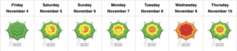
HERE. With clearing, more folks in the SLC mountains are finding evidence of many natural avalanches from the Wednesday HIGH avalanche danger.