Mountain temperatures are in the 20’s and winds are from the south and southwest and strong, averaging in the 20's and 30's mph, with gusts upwards of 70 mph above as low as 8500'
Overnight snowfall totals are 4-8” in the Ogden mountains.
For today’s weather, you can expect mountain temperatures in the 20’s with 4-6” additional snowfall. Winds will be from the southwest and west, gusting in the 20’s and 30’s above 8500’, with even stronger gusts along upper elevation ridgelines.
There were no reports of avalanches in the Ogden backcountry on Saturday, but to the south in the Salt Lake mountains there were
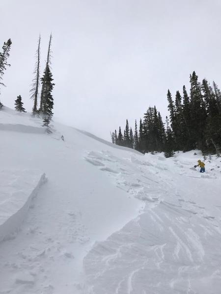
8 human-triggered avalanches reported from the backcountry on Saturday. These were all hard wind slabs, 6” to 24” thick and 25’ to 200’ wide. Some ran up to 350’ vertical. In 4 of the slides, at least one member of the party went for a ride, with injuries involved in 2 of the occurrences. These hard wind slabs were on slopes facing north, northeast, and east, aspects what we refer to as
leeward as they were drifted from the
windward south, southwest, and westerly winds. However, one slide was on a west aspect, indicating how terrain can channel winds and deposit fresh drifts on almost any aspect. These slides were all in large, open, exposed terrain, and generally above 9500', although one very close call on Blue Ice in Broads Fork (
observation) was at 9000'.
Below is a photo from a slide in Maybird Gulch (pic Reed Sullivan)
You can read about all of the reported avalanche activity by clicking
here. Thanks to everyone for their field reports from Saturday.