Forecast for the Moab Area Mountains

Dave Garcia
Issued by Dave Garcia for
Tuesday, March 8, 2022
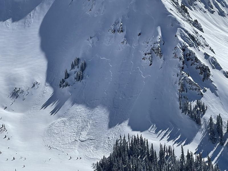
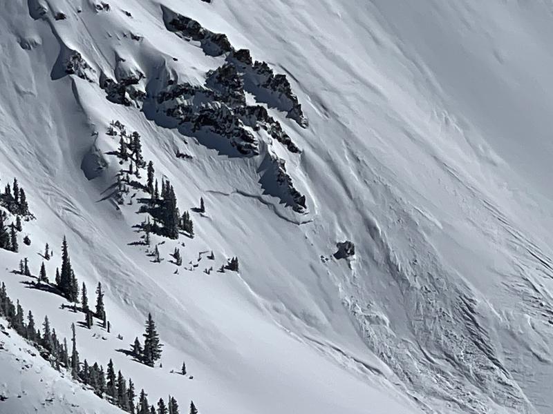
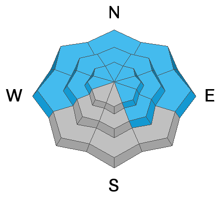
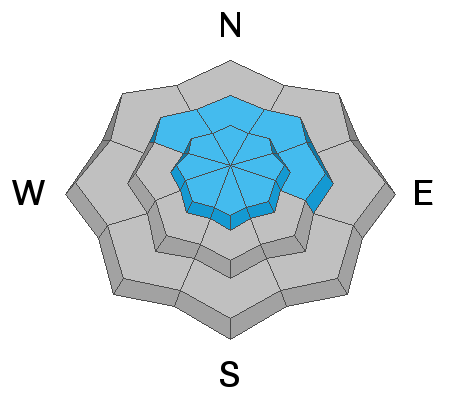
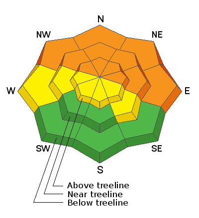
The avalanche danger remains CONSIDERABLE on slopes facing NW-N-NE-E. Human triggered avalanches are likely failing on a buried persistent weak layer 2-3 feet below the surface. This weak layer can also be found on slopes facing W and SE but sun and warm temperature last week have made avalanches on this weak layer less likely. A MODERATE avalanche danger exists on these slopes.
You will find a MODERATE danger for triggering an avalanche in wind drifted snow on all aspects above treeline.
South facing terrain at and below treeline offers a LOW danger.
Low
Moderate
Considerable
High
Extreme
Learn how to read the forecast here
Special Announcements
Road Conditions: Grand County plowed the road Monday morning and driving conditions are good. All wheel drive and good tires are still recommended.
Grooming: Trails were packed into Gold Basin on Sunday and are now covered in 4"-6" of new snow.
Weather and Snow
6:00 a.m. weather data:
24 Hour Snow 0" 72 Hour Snow 18" Base Depth at Gold Basin 72" Wind NW 10-20 Temp -5F
The latest round of snow is over leaving the mountains coated in a fresh blanket of white. Skies are clear this morning and temperatures are cold. Cold temperatures will remain today as the last trough takes its time to push out. Today should be a beautiful day with clear skies, sunshine, and 10,000' temps around 16 degrees. Winds will blow 10 to 15 mph out of the West.
Gold Basin SNOTEL site (10,000')
Storm Totals in Gold Basin
Wind Station on Pre Laurel Peak (11,700')
Snowpack
The weekend storm delivered impressive snow totals up to 27" with the last six inches falling late Sunday night. The top foot or so of snow came in cold and light with very little wind. Classic cold smoke. Skiing and riding conditions remain five star in sheltered terrain. The snow pack is still adjusting to this load and remains unstable, particularly on the north half of the compass. Above treeline, the distribution of the weak layer is much more variable however, recent and wind drifted snow have created their own problems up there, and the bottom line is that all steep, northerly facing terrain should be avoided.
Recent Avalanches
In our travels on Sunday, we noticed several natural avalanches in Gold basin. Above treeline, avalanche types ran the full spectrum from dry loose, to soft storm and wind slab, to avalanches failing on the buried persistent weak layer. Some of the slides that failed on the buried PWL were D2 in size, large enough to fully bury a person. Go here for a list of all recent avalanche activity.
Avalanches failing on a persistent weak layer above treeline in Gold Basin. Tim Mathews photos.
Ad
Avalanche Problem #1
Persistent Weak Layer
Type
Location
Likelihood
Size
Description
20"-27" of new snow at around 2.0" SWE has been added to our buried persistent weak layer and conditions remain dangerous. This buried weak layer of loose, sugary faceted snow is present on W-N-SE aspects and is now buried by 2' -3' of snow. This problem is most pronounced on slopes facing NW-N-NE-E near treeline and below. The most recent loading event was enough to produce natural avalanches 2-3' feet deep. Slopes that did not avalanche are left right at their breaking point. The additional weight of a skier or rider may be all it takes to overburden these sensitive weak layers and produce an avalanche. The snow pack needs more time to stabilize and for now steep northerly slopes should be avoided. Above treeline the weak layer distribution is much more variable but it is hard to track and riding low angle or South facing slopes is your best bet right now. If you are looking to travel to South facing slopes today, keep in mind what slopes are above and adjacent to you. Even the slightest aspect change can change the snow pack under your feet. When in doubt, get out your shovel and look for buried facets. They will be 2-3 feet down and will feel loose, sugary, and less cohesive than the snow on top.
On Sunday my party covered a variety of aspects. Tim Matthews did an excellent write up of our travels, go here for his thoughts on our snow pack.
Avalanche Problem #2
Wind Drifted Snow
Type
Location
Likelihood
Size
Description
Winds shifted to the NW and N around 5 PM yesterday. For about a 7 hour period they blew in the 10-25 mph range mainly out of the N. There is plenty of light density snow available for transport after the storm. This will have left fresh drifts in places we don't normally expect to find wind loading. Expect to find fresh, sensitive wind drifted snow on all aspects above treeline.
Additional Information
General Announcements
Who's up for some free avalanche training? Get a refresher, become better prepared for an upcoming avalanche class, or just boost your skills. Go to https://learn.kbyg.org/ and scroll down to Step 2 for a series of interactive online avalanche courses produced by the UAC.
This forecast is from the U.S.D.A. Forest Service, which is solely responsible for its content. This forecast describes general avalanche conditions and local variations always occur.