UDOT PLANNED AVALANCHE CLOSURES!!

Forecast for the Moab Area Mountains

Dave Garcia
Issued by Dave Garcia for
Wednesday, March 9, 2022
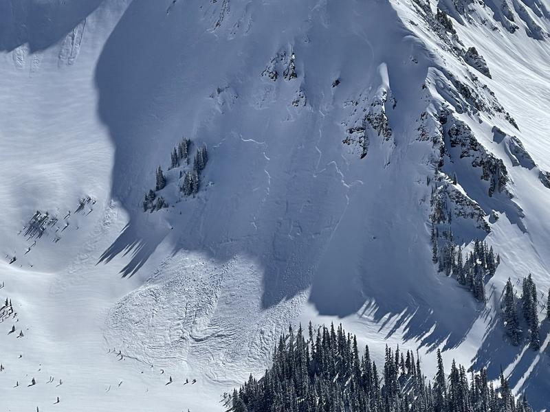
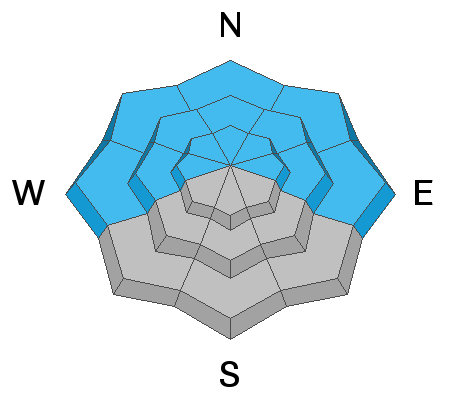
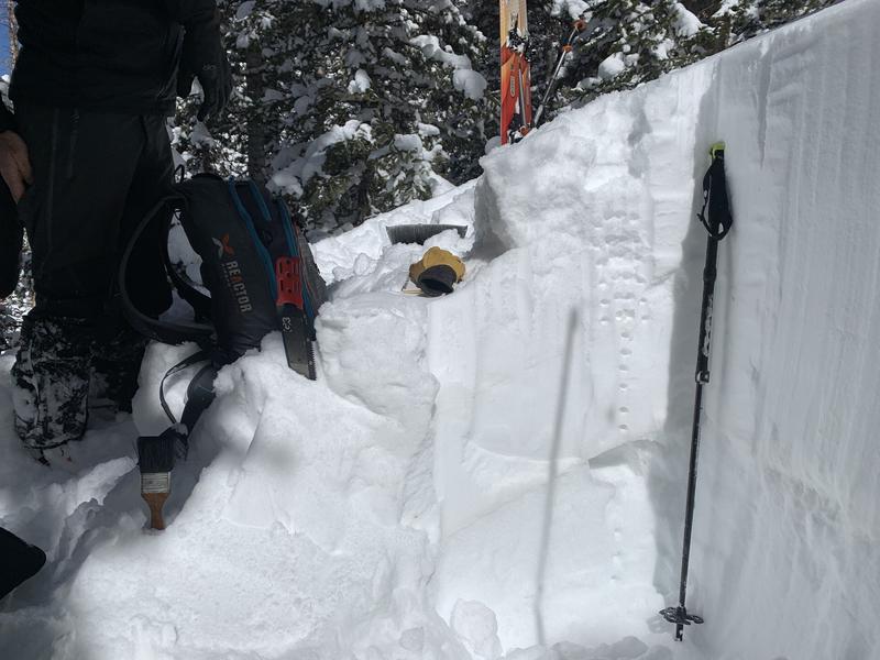
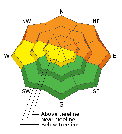
The avalanche danger remains CONSIDERABLE on slopes facing NW-N-NE-E. Human triggered avalanches are likely failing on a buried persistent weak layer 2-3 feet below the surface. This weak layer can also be found on slopes facing W, but sun and warm temperature last week have made avalanches on this weak layer less likely. A MODERATE avalanche danger exists on W facing slopes.
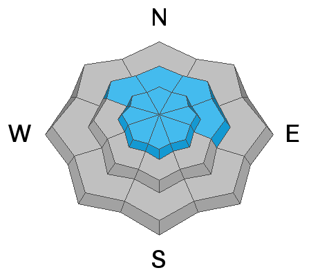
You will find a MODERATE danger for triggering an avalanche in wind drifted snow on all aspects above treeline.
SW-S-SE facing terrain at and below treeline offers a LOW danger.
Low
Moderate
Considerable
High
Extreme
Learn how to read the forecast here
Special Announcements
Road Conditions: Grand County plowed the road Monday morning and driving conditions are good. All wheel drive and good tires are still recommended.
Grooming: Trails were packed into Gold Basin by Eric on Tuesday.
Weather and Snow
6:00 a.m. weather data:
24 Hour Snow 0" 72 Hour Snow 6" Base Depth at Gold Basin 72" Wind WSW 10-15 Temp 9F
There's another storm on our door step, but this one looks to mainly affect points north. We will see scattered snow showers today with maybe 2-4 inches by tomorrow. WSW winds will ramp up today and by the afternoon will be blowing 20-25 mph with gusts close to 40 mph. A SW flow will feed into the area on Thursday keeping skies cloudy with lingering snow showers. This system will keep mountain temperatures relatively cold through Friday. Friday and Saturday will see a return to sunny skies.
Gold Basin SNOTEL site (10,000')
Storm Totals in Gold Basin
Wind Station on Pre Laurel Peak (11,700')
Snowpack
South faces saw a lot of sun yesterday and there was moisture in the snow. I would expect to find a thin crust on SW and S this morning. Other aspects offer great skiing with light density powder. The snow pack is still adjusting to recent loading and remains unstable, particularly on the north half of the compass. The buried weak layer was still reactive yesterday and we are continuing to avoid avalanche terrain on Polar aspects. Above treeline, the distribution of the weak layer is much more variable however, recent and wind drifted snow have created their own problems up there.
Recent Avalanches
Go here for a list of all recent avalanche activity.
This avalanche in Gold Basin happened over the weekend during the storm. This avalanche is large enough to bury a person. A human triggered avalanche today could be the same size. (Photo Tim Matthews).
Ad
Avalanche Problem #1
Persistent Weak Layer
Type
Location
Likelihood
Size
Description
The weekend storm added just over 2" of water to our buried persistent weak layer and conditions remain dangerous. This weak layer of loose, sugary faceted snow is present on W-N-SE aspects and is now buried by 2' -3' of snow. This problem is most pronounced on slopes facing NW-N-NE-E near treeline and below. We continued to find unstable conditions in our travels yesterday. We experienced collapsing as we traveled near tree line and below on shady slopes. Collapsing has been consistent all week in terrain features like steep, shaded areas in the trees. I would expect backcountry travelers to encounter more collapsing today in these places. Our stability tests continue to produce failures in snow pits. Yesterday we got an ECTP21 on a NNW slope around 10,500 ft. All of this is an indication that avalanche terrain is not to be trusted on the North side of the compass. Above treeline the weak layer distribution is much more variable but it is hard to track and riding low angle or Solar aspects is your best bet right now.
Avalanche Problem #2
Wind Drifted Snow
Type
Location
Likelihood
Size
Description
Monday night and Tuesday morning saw moderate winds out of the North. These North winds drifted snow onto Southerly aspects. While skiing yesterday we noticed cross loading in gullies and sub ridges on just about all aspects above treeline. With the next storm on our doorstep the winds will ramp up once again blowing 20-25 out of the WSW today. There is still plenty of light density snow out there available for transport and fresh drifts will be deposited once again above tree line. Avoid rounded, pillowy looking areas. Cracking and hollow sounds are a good indication that you have stepped onto a wind slab.
Additional Information
A pit profile on a NW facing slope around 10,700 ft. The weak layer of facets is seen between 70-95 cm.
I've included this picture of the pit wall so you can better understand the snow profile graphic.
General Announcements
Who's up for some free avalanche training? Get a refresher, become better prepared for an upcoming avalanche class, or just boost your skills. Go to https://learn.kbyg.org/ and scroll down to Step 2 for a series of interactive online avalanche courses produced by the UAC.
This forecast is from the U.S.D.A. Forest Service, which is solely responsible for its content. This forecast describes general avalanche conditions and local variations always occur.